Area Overview for SG2 7DE
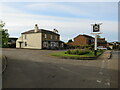
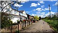
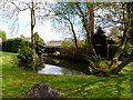
Photos of SG2 7DE


Area Information
Living in SG2 7DE offers a quiet life within a small residential cluster in Hertfordshire. This specific postcode covers 8.5 hectares, creating a compact community where residents know their neighbours. The area holds a population of 1,439 people, resulting in a low density of 48 people per square kilometre. You will find spacious surroundings rather than the crowded streets found in larger towns. Daily life here moves at a slower pace, with ample green space and a lack of heavy traffic congestion typical of postcodes in bigger cities. The setting is ideal for those seeking a tranquil environment away from the post-city commutes of Stevenage road networks. While the area is small, it provides a solid foundation for building a stable community home. You gain immediate access to the wider region while maintaining a secluded feel. This balance makes SG2 7DE a practical choice for individuals prioritising space and peace over urban bustle. The low population density ensures that the local environment remains manageable for residents regardless of family size.
- Area Type
- Postcode
- Area Size
- 8.5 hectares
- Population
- 1439
- Population Density
- 48 people/km²
The property market in SG2 7DE is defined by its strong owner-occupier stance, with 71% of homes sold privately rather than rented. Almost all available housing consists of houses, meaning you will find detached, semi-detached, or terraced family homes rather than flats or apartments. This stock profile caters to families and mature buyers who require single-storey access or garden space. The low population density of 48 people per square kilometre correlates with ample space between properties. Buyers looking for rental schemes or high-density apartment living will find few matches in this postcode. Instead, the market rewards those seeking traditional British suburban housing near Watton and Ardeley. The mix of accommodation types supports a quiet, established neighbourhood feel. You will not find the rapid turnover often seen in student cities or investor-heavy zones. The market reflects a desire for permanence, with most transactions involving long-term residents moving within the area or relocating from outside. Homes here command value based on their proximity to local schools and peace of the region.
House Prices in SG2 7DE
Showing 7 properties
| Address | Type | Beds | Baths | Last Sale Price | Last Sale Date | |
|---|---|---|---|---|---|---|
| 90 Whempstead Road, Benington, SG2 7DE | Bungalow | - | - | £850,000 | Aug 2024 | |
| 72 Whempstead Road, Benington, SG2 7DE | Detached | 4 | 3 | £825,000 | Oct 2012 | |
| 70 Whempstead Road, Benington, SG2 7DE | Detached | - | - | £1,175,000 | Aug 2011 | |
| 74 Whempstead Road, Benington, SG2 7DE | Detached | 5 | 4 | £710,000 | Sep 2008 | |
| 88 Whempstead Road, Benington, SG2 7DE | Detached | 5 | 4 | £480,000 | Jun 2003 | |
| 68 Whempstead Road, Benington, SG2 7DE | Bungalow | 3 | 1 | - | - | |
| Elstow House, Whempstead Road, Benington, SG2 7DE | Detached | 6 | - | - | - |
Energy Efficiency in SG2 7DE
Residents of SG2 7DE enjoy practical access to essential retail and rail transport within a short drive. Five major retail outlets are nearby, including Budgens Watton at, Sainsburys Stevenage, and Budgens Walkern, covering most grocery and household shopping needs. Transport links are equally accessible, with five rail stations offering reasonable commuting options. Watton, Knebworth Railway Station, and Stevenage Railway Station connect you to wider Hertfordshire and London. These amenities are within practical reach of the 8.5-hectare resident population. You can handle weekly shop runs without long drives while keeping travel times to work manageable. The presence of Sainsburys and multiple Budgens locations suggests a convenience-focused shopping experience close to the homes. Rail options provide flexibility for those wishing to avoid road traffic or reduce carbon emissions. This combination of local shops and national rail stations creates a balanced lifestyle where daily errands are straightforward.
Amenities
Schools
Families in SG2 7DE have access to two specific primary schools within close reach. Benington Church of England Primary School operates in the vicinity and holds a good Ofsted rating. Ardeley St Lawrence Church of England Voluntary Aided Primary School also serves the local catchment and similarly receives a good Ofsted rating. The presence of two highly rated primary options provides flexibility for parents depending on their specific address within the postcode. Both institutions focus on foundational education with a religious character element embedded in their names. This concentration of quality primary education means secondary school choices may depend on catchment boundaries outside this immediate cluster. You do not need to travel far for early year enrolments as both schools serve the SG2 7DE demographic well. The good ratings from Ofsted suggest consistent standards in teaching and student pastoral care. Neighbours can rely on these facilities for their children's early education before transitioning to older schools further away.
| Rank | School | Type | Entry gender | Ages |
|---|
Explore more schools in this area
Go to Schools tabDemographics
The community in SG2 7DE skews towards mature households, with a median age of 47 years. Most residents fall into the 30 to 64 years age range, reflecting a settled lifestyle rather than a student-heavy area. You are likely to encounter families and empty nesters rather than young professionals moving in for temporary leases. Home ownership is the norm, with 71% of homes held by owners rather than tenants. This high rate indicates a stable neighbourhood where residents have long-term roots in the local property market. The predominant population is White, aligning with the broader demographic makeup of the region. Accommodation consists primarily of houses, providing the detached or semi-detached dwellings sought after by families and retirees. The absence of social housing data suggests a market-driven purchase environment. This profile means you will find a diverse group of families, couples, and singles managing their own properties. The stability of the demographic makes SG2 7DE a reliable location for priority schooling and consistent community engagement.
Household Size
Accommodation Type
Tenure
Ethnic Group
Religion
Household Composition
Age
Household Deprivation
NS-SEC
Explore more demographic insights in this area
Go to Demographics tabPlanning
Planning Constraints
- Flood RiskPremium
- Ramsar Wetland SitesPremium
- Area of Outstanding Natural BeautyPremium
- Protected Nature ReservePremium
- Protected WoodlandPremium