Area Overview for SG18 8UQ
Photos of SG18 8UQ


Area Information
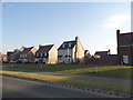
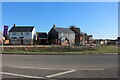
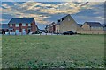
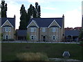
Living in SG18 8UQ offers a distinctly residential experience within a small, tightly defined cluster. This specific postcode covers an area of just 2.3 hectares, creating a compact environment where neighbours are within immediate sight. With a population of 1,444, the area maintains a sense of intimacy while remaining part of the broader local network. High population density, recorded at 62,434 people per square kilometre, reflects the concentrated nature of this residential pocket. The community feels established, anchored by a steady demographic profile rather than constant flux. Daily life here moves at a measured pace, far removed from the rush of larger urban centres. You will find a setting that prioritises quiet living close to essential services. The geography supports a high degree of connection between homes and local infrastructure without the sprawl of larger developments. This makes SG18 8UQ a practical choice for those seeking a home near the action but without the associated chaos. The area functions as a stable residential hub, seamlessly integrating into the surrounding towns of Biggleswade, Sandy, and Arlesey.
- Area Type
- Postcode
- Area Size
- 2.3 hectares
- Population
- 1444
- Population Density
- 7072 people/km²
The property market in SG18 8UQ is characterised by a strong housing stock and a distinct lack of rental dependency. A substantial majority of residents, accounting for 76% of the population, own their homes outright or with a mortgage. This high home ownership rate signifies that the area functions as a stable, owner-occupied community rather than a transient rental sector. Houses remain the predominant form of accommodation, meaning buyers can expect to find detached, semi-detached, or terraced family properties throughout the postcode. The small footprint of the area, measuring only 2.3 hectares, limits the volume of listings but ensures that each property holds significant value due to scarcity. You will find that competition for available homes in SG18 8UQ can be fierce, given the compact size and high demand. This specific postcode is not a stepping stone for investors looking for quick flips; it is a destination for those building equity. The market reflects a area where people intend to stay for the long term, fostering a stable neighbourhood with consistent property values.
House Prices in SG18 8UQ
No properties found in this postcode.
Energy Efficiency in SG18 8UQ
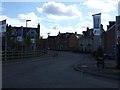
Your daily life in SG18 8UQ is enriched by immediate access to high-quality retail and transport links in nearby Biggleswade. You can shop at Sainsburys Biggleswade, Co-op Biggleswade, or Iceland Biggleswade, all within practical travelling distance. These supermarkets provide everything from fresh produce to household essentials, eliminating the need for weekly supermarket runs to distant towns. Grocery shopping fits easily into your schedule thanks to this close proximity. Beyond shopping, connectivity is supported by a network of three railway stations: Biggleswade Railway Station, Sandy Railway Station, and Arlesey Railway Station. These hubs link the area to wider regional networks, making commuting straightforward. The combination of immediate retail options and rapid rail access defines the lifestyle convenience of SG18 8UQ. Residents enjoy a balance of suburban quiet and urban accessibility. You do not need a car for every task, yet you maintain the ability to travel quickly when required.
Amenities
Schools
| Rank | School | Type | Entry gender | Ages |
|---|
Explore more schools in this area
Go to Schools tabDemographics
The community in SG18 8UQ is defined by a mature and settled population. The median age stands at 47 years, indicating that adults between the ages of 30 and 64 make up the most common age range. This demographic skew suggests families and professionals with established careers rather than young students or retirees. Home ownership is a cornerstone of the neighbourhood, with 76% of residents owning their homes. This high figure points to long-term stability and reduced turnover within the local streets. Houses constitute the primary accommodation type, reinforcing the family-oriented character of the district. The ethnic composition is predominantly White, which aligns with the broader historical makeup of many established suburban areas in England. The absence of significant deprivation markers means the quality of life remains consistent across the postcode. Residents benefit from a environment where financial struggles do not disrupt the fabric of everyday neighbourhood life. The demographic profile supports local businesses that cater to a wide demographic, from young professionals to older homeowners. This stability creates a predictable and supportive social environment for anyone considering moving into SG18 8UQ.
Household Size
Accommodation Type
Tenure
Ethnic Group
Religion
Household Composition
Age
Household Deprivation
NS-SEC
Explore more demographic insights in this area
Go to Demographics tabPlanning
Planning Constraints
- Flood RiskPremium
- Ramsar Wetland SitesPremium
- Area of Outstanding Natural BeautyPremium
- Protected Nature ReservePremium
- Protected WoodlandPremium