Area Overview for SG18 0PW
Photos of SG18 0PW

Area Information
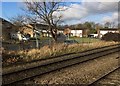
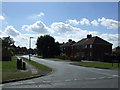
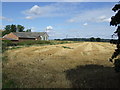
Living in SG18 0PW means residing within a specific postcode area covering a small residential cluster in England. This compact neighbourhood forms a distinct part of the local landscape, offering a settled environment for its inhabitants. The community comprises a population of 1,551 people, creating a close-knit atmosphere where residents know one another. This residential cluster is characterised by a focus on housing rather than commercial or industrial development. Daily life here revolves around the immediate surroundings of this small demographic group. You will find a setting that supports a stable, family-oriented way of living within a defined geographic boundary. The area maintains a clear residential identity, avoiding the sprawl of larger towns while still providing access to nearby services. Prospective buyers can expect a quiet existence defined by the presence of houses and a steady community rhythm. This postcode represents a practical choice for those seeking a home in a concentrated, manageable locality with established features.
- Area Type
- Postcode
- Area Size
- Not available
- Population
- 1551
- Population Density
- 4682 people/km²
The property market in SG18 0PW is heavily characterised by private ownership and traditional housing stock. With 72% of the population listed as homeowners, this area is overwhelmingly owner-occupied rather than a rental hotspot. This statistic means you are more likely to find sellers passing on a family home than tenants looking for short-term leases. The accommodation type is exclusively houses, which dictates the nature of the housing available. You will encounter detached, semi-detached, or terraced houses suitable for various family sizes, but no flats exist in this specific section. This uniformity creates a consistent street landscape where every house shares the same fundamental footprint and character. Buyers investigating homes in SG18 0PW should expect to join an existing community of invested residents. The lack of rental properties suggests a market driven by long-term commitment and local knowledge. This environment is stable for purchasers who prioritise a house in a quiet setting over the convenience of a leasehold flat. The market reflects a community that has chosen to build equity rather than accommodate transient populations.
House Prices in SG18 0PW
No properties found in this postcode.
Energy Efficiency in SG18 0PW
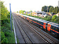
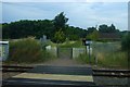
Residents of SG18 0PW enjoy convenient access to key amenities within practical reach of their homes. For Retail, there are five notable shopping options available, including Sainsburys Biggleswade, Asda Biggleswade, and Iceland Biggleswade. These supermarkets provide your essentials, fresh produce, and weekly grocery needs without requiring a long journey. Transport links are equally well supported with three railway stations nearby: Biggleswade Railway Station, Sandy Railway Station, and Arlesey Railway Station. These stations offer regular train services that connect you to larger regional centres and cities. The presence of multiple retail outlets and rail links ensures that daily errands and commuting are manageable. You can walk to small shops or drive to the supermarkets for larger purchases. The railway connections mean that if work or leisure takes you away from this quiet postcode, departure is straightforward. This arrangement balances the tranquility of village life with the accessibility of major facilities. Living in SG18 0PW gives you the best of both worlds regarding location and convenience.
Amenities
Schools
Families living in SG18 0PW have access to specific educational institutions nearby, providing options for schooling from early years onwards. One option is Edward Peake CofE VC School, which operates as a primary school and holds a Good rating from Ofsted. This designation confirms the school meets high standards of education and conduct for younger children. Additionally, Hitchmead School is located near the area and functions as a special school, catering to specific educational needs. This mix of provision means that mainstream primary education is readily available with high quality assessment results. While no secondary schools are listed in the immediate vicinity, the presence of Edward Peake ensures adequate cover for primary education. The proximity of these institutions means parents can easily navigate their children's schooling without needing to travel far. The combination of a rated primary and a special provision school indicates a consideration for diverse educational requirements within the local catchment. Living in SG18 0PW allows families to take advantage of these established educational facilities which serve the immediate residential community.
| Rank | School | Type | Entry gender | Ages |
|---|
Explore more schools in this area
Go to Schools tabDemographics
The community in SG18 0PW is defined by a mature and established population structure. The median age in this area is 47 years, indicating a demographic skewed towards middle-aged residents. Most commonly, the population consists of adults aged between 30 and 64 years, forming the backbone of the local neighbourhood. Home ownership is a dominant feature, with 72% of households owning their homes outright or with a mortgage. This high level of equity reflects long-term residents who have put down roots in the area. The accommodation type is exclusively houses, meaning you will not find flats or apartments within this specific postcode. The predominant ethnic group is White, which aligns with the traditional character of many established English villages. There is no significant deprivation data provided to suggest financial hardship exists here. Instead, the demographics point towards a stable, self-funded community where residents likely value stability and ownership over renting. This profile suggests a neighbourhood geared towards families and empty nesters rather than young professionals or students.
Household Size
Accommodation Type
Tenure
Ethnic Group
Religion
Household Composition
Age
Household Deprivation
NS-SEC
Explore more demographic insights in this area
Go to Demographics tabPlanning
Planning Constraints
- Flood RiskPremium
- Ramsar Wetland SitesPremium
- Area of Outstanding Natural BeautyPremium
- Protected Nature ReservePremium
- Protected WoodlandPremium