Area Overview for SG13 8EE
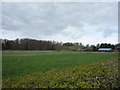
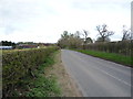
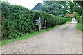
Photos of SG13 8EE


Area Information
Living in SG13 8EE offers a quiet residential experience within a defined postcode cluster. This specific location hosts 2643 residents across a spread of 29.4 square kilometres, resulting in a population density of 89 people per square kilometre. The area functions primarily as a housing zone rather than a commercial hub, meaning your daily routine will centre on domestic life with essential services located a short distance away. The low density creates a more secluded environment compared to the denser urban sprawls of Greater London. Residents here enjoy a neighbourhood character defined by its scale and layout. You are part of a community where space is abundant, yet local amenities remain accessible. The area covers a small cluster of homes that allows for a distinct independence from the busier pressures of Hertfordshire's main towns. Your view from the property is likely to be of suburban greenery or other homes, rather than high-rise developments. This layout suits those who value a calm atmosphere but still require practical access to national rail networks and retail centres like those in nearby Hertford. The postcode serves as a specific address for a slice of Hertfordshire that balances suburban detachment with functional connectivity. You live in an area where the estate feels spacious and characterful, avoiding the congestion found in more populated districts. Daily life revolves around the home, with travel to work or leisure handled efficiently via the available transport links. This setting provides a stable foundation for families and individuals seeking a home free from the intensity of larger urban centres.
- Area Type
- Postcode
- Area Size
- Not available
- Population
- 2643
- Population Density
- 89 people/km²
The property market in SG13 8EE is characterised by a strong owner-occupier presence. With 77% of the population owning their homes, the area is not dominated by short-term rentals or student housing. This statistic confirms that the demand here is driven by people seeking to settle down rather than lookers who move frequently. The accommodation type confirms that the housing stock consists of houses. This means buyers can expect semi-detached, detached, or terraced properties, but you will not find purpose-built flats or mansion blocks as the main offering. This focus on house ownership creates a market where property values are generally stable and tied to improvement works and local amenities. Buyers looking at this small area will find a consistent product: residential properties designed for families and individuals seeking privacy. The high owner-occupancy rate also suggests that the area undergoes slower turnover, which can mean stronger local ties and perhaps slightly higher competition when a property does come onto the market. For those considering homes in SG13 8EE, the absence of rental pressure is a significant factor. You are purchasing a home in a district where the neighbours are likely to be long-term residents. This setup avoids the tenant turnover common in high-yield investment zones. The market reflects a preference for established housing over new builds or conversions, as the current stock already meets the needs of the local demographic. If you value a traditional suburban environment, this data supports moving to a house in this specific postcode rather than an apartment complex.
House Prices in SG13 8EE
No properties found in this postcode.
Energy Efficiency in SG13 8EE
Your lifestyle in SG13 8EE revolves around a quiet home base with convenient access to key retail and transport hubs. Five notable retailers operate within easy reach, providing daily necessities without the need to travel far into town. You can shop at Aldi Hertford, M&S Hertford SF, and a Co-op Fleming to cover groceries and household items. These outlets form the core of the local high street experience, offering practical solutions to weekly shopping demands. Transport is facilitated by five railway stations nearby, with Bayford, Hertford North, and Hertford East being the primary options. This concentration of rail access ensures that commuting is straightforward. The proximity of these stations means you can manage daily travel to work without relying solely on private vehicles for some journeys. This balance allows for car-free commutes for certain trips while maintaining the flexibility of car ownership for local errands. The area lacks large shopping centres or entertainment complexes immediately adjacent to the residential pods, but the identified amenities provide sufficient scope for routine living. You spend your days in a calm environment, with all essential services located minutes away by car or train. This setup suits those who prefer a slower pace of life where the local shops and stations handle most social and practical interactions. Living in SG13 8EE means prioritising a settled routine supported by reliable, nearby facilities.
Amenities
Schools
Families in SG13 8EE are well positioned regarding educational options within a practical commute. The area has access to several primary schools, most notably Bayford Church of England Voluntary Controlled Primary School, which holds an Ofsted rating of good. Another key option is Hertingfordbury Cowper Primary School, also rated good, providing a reliable standard of education. Tewin Cowper Church of England Voluntary Aided Primary School is a local alternative with a satisfactory Ofsted rating. Special education needs are supported by Epping House School, a specialised institution nearby. This mix of mainstream and special provisions ensures that families have diverse choices depending on their children's requirements. The presence of multiple primary schools allows parents to select based on specific educational philosophies or catchment areas without needing to travel excessively far. The school landscape reflects the maturity of the neighbourhood, with a focus on primary education which aligns with the median age of residents. You will find schools that are integrated into the local community structure. The Ofsted ratings provide clear indicators of performance; two schools are rated good, while one is rated satisfactory. This variance offers choice without forcing families to seek education facilities far outside the immediate vicinity. For anyone asking what schools near SG13 8EE offer, the answer includes established Christian schools and a dedicated special needs provision, all within easy reach of the residential cluster.
| Rank | School | Type | Entry gender | Ages |
|---|
Explore more schools in this area
Go to Schools tabDemographics
The community in SG13 8EE is distinctly mature, anchored by a median age of 47 years. The most common age range for residents falls between 30 and 64 years, indicating that the area attracts families and those approaching retirement. With 77% of homes owned outright or with a mortgage, the district functions overwhelmingly as an owner-occupied market. This high level of home ownership suggests long-term stability, as residents are likely to stay in their properties for extended periods rather than circulating rapidly through the rental sector. Accommodation in the area consists almost exclusively of houses. You will not find apartments or flats as the primary dwelling type in this postcode, reinforcing the suburban and family-oriented nature of the location. This structure supports a lifestyle that typically includes gardens and stable neighbourhoods. The predominant ethnic group is White, which aligns with the broader demographic patterns of the surrounding Hertfordshire region. These figures paint a picture of a settled, family-focused community. The high ownership rate means neighbours are likely to have established social networks and a shared interest in maintaining local standards. For those considering homes in SG13 8EE, the resident profile indicates a district suited for parents, retirees, and established adults. You are joining a community where the majority of households are permanent residents invested in their local environment. The age profile ensures that local facilities cater to a wide demographic, from young children in families to older adults in retirement.
Household Size
Accommodation Type
Tenure
Ethnic Group
Religion
Household Composition
Age
Household Deprivation
NS-SEC
Explore more demographic insights in this area
Go to Demographics tabPlanning
Planning Constraints
- Flood RiskPremium
- Ramsar Wetland SitesPremium
- Area of Outstanding Natural BeautyPremium
- Protected Nature ReservePremium
- Protected WoodlandPremium