Area Overview for SG12 9EJ
Photos of SG12 9EJ
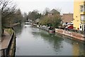

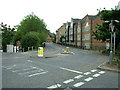
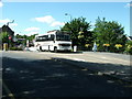


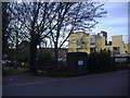
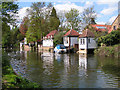

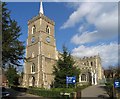
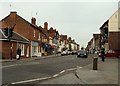
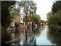
100 photos from this area
Area Information
Key information about the SG12 9EJ including its size, population, and administrative classification.
- Area Type
- Postcode
- Area Size
- 7903 m²
- Population
- 1621
- Population Density
- 944 people/km²
House Prices in SG12 9EJ
90
Properties
£231,606
Average Sold Price
£85,500
Lowest Price
£480,000
Highest Price
Showing 90 properties
| Address | Type | Beds | Baths | Last Sale Price | Last Sale Date | |
|---|---|---|---|---|---|---|
| 16, Fusion Court, Broadmeads, Ware, SG12 9EJ | Flat | - | - | £315,000 | Feb 2025 | |
| 56, Fusion Court, Broadmeads, Ware, SG12 9EJ | Flat | 2 | 2 | £310,000 | Dec 2024 | |
| 39, Fusion Court, Broadmeads, Ware, SG12 9EJ | Flat | 2 | 2 | £300,000 | Nov 2024 | |
| 18, Fusion Court, Broadmeads, Ware, SG12 9EJ | Flat | 2 | - | £290,000 | Nov 2024 | |
| 88, Fusion Court, Broadmeads, Ware, SG12 9EJ | Flat | - | - | £96,000 | Aug 2024 | |
| 24, Fusion Court, Broadmeads, Ware, SG12 9EJ | Flat | - | - | £280,000 | Jul 2024 | |
| 79, Fusion Court, Broadmeads, Ware, SG12 9EJ | Flat | - | - | £97,550 | Jun 2024 | |
| 31, Fusion Court, Broadmeads, Ware, SG12 9EJ | Flat | 2 | 2 | £150,000 | Feb 2024 | |
| 17, Fusion Court, Broadmeads, Ware, SG12 9EJ | Flat | - | - | £285,000 | Dec 2023 | |
| 46, Fusion Court, Broadmeads, Ware, SG12 9EJ | Flat | - | - | £227,000 | Nov 2023 |
Page 1 of 9
Energy Efficiency in SG12 9EJ
Amenities
Schools
| Rank | School | Type | Entry gender | Ages |
|---|
Explore more schools in this area
Go to Schools tabDemographics
Household Size
Two person
most common
Accommodation Type
Houses
most common
Tenure
79
majority
Ethnic Group
White
most common
Religion
N/A
most common
Household Composition
N/A
most common
Age
47
median
Adults (30-64 years)
most common
Household Deprivation
N/A
with no deprivation
NS-SEC
49
in Lower managerial occupations
Explore more demographic insights in this area
Go to Demographics tabPlanning
Planning Constraints
- Flood RiskPremium
- Ramsar Wetland SitesPremium
- Area of Outstanding Natural BeautyPremium
- Protected Nature ReservePremium
- Protected WoodlandPremium