Area Overview for SG1 3FD
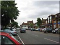
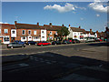
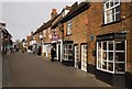
Photos of SG1 3FD


Area Information
Living in SG1 3FD means residing in a tightly clustered residential zone defined by its compact footprint and established character. This specific postcode covers a small geographical area of 8237 square metres, creating an intimate neighbourhood rather than a sprawling district. You are looking at a community where the population stands at 2680 people, resulting in a very high population density of 325359 people per square kilometre. Such density suggests that properties are situated close together, forming a residential cluster where daily interactions with neighbours may be frequent. The location sits within England, positioned to serve as a practical home for those who prioritise community over expansive open spaces. For potential buyers, understanding this compact nature is essential for visualising your future home life. This area offers a concentrated experience of local living where every street is potentially within minutes of another. The sheer volume of residents in such a small space indicates a vibrant, active environment where local amenities serve a concentrated demand. Your daily routine here would be shaped by this proximity, with neighbours effectively becoming part of your immediate social circle. ### The community within SG1 3FD is overwhelmingly composed of adults, with the median age sitting at 47 years. The most common age range for residents falls between 30 and 64 years, indicating a stable population of working-age families or empty-nesters. Home ownership is strong across the area, with 61% of households owning their property outright or with a mortgage. This statistic signals a settled community where long-term residents have taken root. Houses dominate the accommodation type landscape here, meaning you will find detached or semi-detached structures rather than high-rise flats or apartment blocks. The predominant ethnic group is White, reflecting a demographic profile consistent with many established British suburbs. There are no indicators of significant deprivation or extreme wealth segregation mentioned for this cluster. Instead, the numbers paint a picture of a mature, middle-to-upper-income demographic focused on stability. Families and individuals in this age bracket likely value quiet streets and established gardens over the amenities of a younger student quarter or a transient tourist hub. The high rate of house ownership suggests that invest in these homes is viewed as a secure lifetime purchase rather than a short-term rental investment. ### The housing market in SG1 3FD is distinctly characterised by a predominance of houses rather than flats or apartments. With 61% home ownership, the area functions primarily as an owner-occupied community rather than a high-rise rental estate. This high level of tenure implies that the prevailing housing stock consists of family homes where occupants have settled for the long term. Buyers looking for a house in this specific postcode area will find an environment designed for permanent residence rather than transient living. The low density of the cluster, covering just 8237 square metres, reinforces the idea of a residential lane or cul-de-sac rather than a commercial or mixed-use high street. You are unlikely to encounter large blocks of social housing or student accommodation here. Instead, the market reflects a desire for traditional gardens and private outdoor space. This makes SG1 3FD an attractive option for those seeking a conventional British suburban lifestyle. The combination of housefocus and high ownership rates suggests that property values are likely driven by the quality of the individual brick and mortar structures. Potential buyers should expect a market where competition centres on the specific attributes of individual houses. This is a place where you buy a home for generations, not a flat for a few years. ### Digital connectivity in SG1 3FD ranks highly, ensuring that working from home or heavy streaming poses no barrier to daily life. The fixed broadband score reaches 93 out of 100, marking the connection as excellent for all standard internet activities. This level of speed and reliability supports multiple devices, large file downloads, and video conferencing without interruption. Your mobile coverage also scores well at 85 out of 100, providing good signal strength throughout the residential cluster. You can expect reliable calls and data usage whether you are in the garden or driving between local stops. For professionals relying on consistent internet access, this connectivity is a significant advantage. The area does not suffer from the digital voids that plague some rural or outlying suburbs. Commuters can rely on stable connections when logging into remote work portals or accessing cloud storage. The strong infrastructure supports modern living standards where home and office blends increasingly overlap. Residents do not need to rely on spotty Wi-Fi for essential tasks like schoolwork, banking, or entertainment. You move into this postcode knowing your digital life will run smoothly. This excellent tech foundation removes a common anxiety for remote workers choosing their location. ### Your daily life in SG1 3FD is supported by a ring of practical amenities within easy reach. Five retail outlets serve as your shopping destinations, including notable options such as Tesco Old, Morrisons Daily, and Asda Lytton. These supermarkets allow for quick grocery runs and household errands without the need for long journeys. Transport links are equally convenient, with five rail stations in practical proximity. You can reach Stevenage Railway Station, Knebworth Railway Station, or Hitchin Railway Station depending on your destination needs. These stations provide fast links to London and other parts of the country, making commutes efficient. The combination of local shops and major train hubs creates a balanced lifestyle where you do not have to commute far for basics or work. Dining and grocery shopping become quick tasks rather than weekend excursions. The proximity of Asda Lytton and Tesco Old means fresh food is available around the corner. You value the convenience of having Morrisons Daily close by for lighter shopping trips. The presence of five railway stations nearby ensures that your travel options are flexible. This accessibility supports a dynamic life where you can work from home when desired yet travel quickly for leisure or business. Amenities are not distant luxuries but integrated parts of your routine. ### Safety and environmental factors in SG1 3FD present a mixed picture that requires realistic consideration. The flood risk assessment passes with a score of 0, indicating low flood risk coverage. You can move here without concern regarding water damage from rising tides or heavy rainfall. There are no Ramsar wetland sites, areas of outstanding natural beauty, protected nature reserves, or protected woodland covering this territory. These planning constraints are effectively absent, meaning developers face fewer restrictions on local land use. However, the crime risk assessment registers a level of WARNING with a score of 59. This score indicates a medium crime risk where rates are around the national average. Safety score stands at 59 out of 100, suggesting that standard security precautions remain advisable for all residents. You should not assume this is a crime-free zone, but the data does not point to an extreme danger either. The environment contains no major planning constraints that would hinder future development. The passing flood and nature tests are positive for those concerned about environmental liabilities. Residents must simply remain vigilant against typical urban or suburban crime issues. The overall safety profile is average, reflecting a typical residential suburb rather than a high-security estate or a high-risk urban district. ### Who typically lives in SG1 3FD?Residents are predominantly adults aged between 30 and 64 years, with a median age of 47. The predominant ethnic group is White, and 61% of households own their homes. How safe is the area compared to the rest of the country?The area carries a WARNING level for crime risk with a score of 59. This indicates a medium crime risk where crime rates are around average. What amenities are within walking or short driving distance?You have access to five retail venues including Tesco Old, Morrisons Daily, and Asda Lytton. Additionally, five railway stations including Stevenage and Knebworth are nearby. Will I have reliable internet for working from home?Yes, the area scores 93 out of 100 for fixed broadband and 85 out of 100 for mobile coverage. This level of connectivity is classified as excellent.
- Area Type
- Postcode
- Area Size
- 8237 m²
- Population
- 2680
- Population Density
- 4255 people/km²
The housing market in SG1 3FD is distinctly characterised by a predominance of houses rather than flats or apartments. With 61% home ownership, the area functions primarily as an owner-occupied community rather than a high-rise rental estate. This high level of tenure implies that the prevailing housing stock consists of family homes where occupants have settled for the long term. Buyers looking for a house in this specific postcode area will find an environment designed for permanent residence rather than transient living. The low density of the cluster, covering just 8237 square metres, reinforces the idea of a residential lane or cul-de-sac rather than a commercial or mixed-use high street. You are unlikely to encounter large blocks of social housing or student accommodation here. Instead, the market reflects a desire for traditional gardens and private outdoor space. This makes SG1 3FD an attractive option for those seeking a conventional British suburban lifestyle. The combination of housefocus and high ownership rates suggests that property values are likely driven by the quality of the individual brick and mortar structures. Potential buyers should expect a market where competition centres on the specific attributes of individual houses. This is a place where you buy a home for generations, not a flat for a few years. ### Digital connectivity in SG1 3FD ranks highly, ensuring that working from home or heavy streaming poses no barrier to daily life. The fixed broadband score reaches 93 out of 100, marking the connection as excellent for all standard internet activities. This level of speed and reliability supports multiple devices, large file downloads, and video conferencing without interruption. Your mobile coverage also scores well at 85 out of 100, providing good signal strength throughout the residential cluster. You can expect reliable calls and data usage whether you are in the garden or driving between local stops. For professionals relying on consistent internet access, this connectivity is a significant advantage. The area does not suffer from the digital voids that plague some rural or outlying suburbs. Commuters can rely on stable connections when logging into remote work portals or accessing cloud storage. The strong infrastructure supports modern living standards where home and office blends increasingly overlap. Residents do not need to rely on spotty Wi-Fi for essential tasks like schoolwork, banking, or entertainment. You move into this postcode knowing your digital life will run smoothly. This excellent tech foundation removes a common anxiety for remote workers choosing their location. ### Your daily life in SG1 3FD is supported by a ring of practical amenities within easy reach. Five retail outlets serve as your shopping destinations, including notable options such as Tesco Old, Morrisons Daily, and Asda Lytton. These supermarkets allow for quick grocery runs and household errands without the need for long journeys. Transport links are equally convenient, with five rail stations in practical proximity. You can reach Stevenage Railway Station, Knebworth Railway Station, or Hitchin Railway Station depending on your destination needs. These stations provide fast links to London and other parts of the country, making commutes efficient. The combination of local shops and major train hubs creates a balanced lifestyle where you do not have to commute far for basics or work. Dining and grocery shopping become quick tasks rather than weekend excursions. The proximity of Asda Lytton and Tesco Old means fresh food is available around the corner. You value the convenience of having Morrisons Daily close by for lighter shopping trips. The presence of five railway stations nearby ensures that your travel options are flexible. This accessibility supports a dynamic life where you can work from home when desired yet travel quickly for leisure or business. Amenities are not distant luxuries but integrated parts of your routine. ### Safety and environmental factors in SG1 3FD present a mixed picture that requires realistic consideration. The flood risk assessment passes with a score of 0, indicating low flood risk coverage. You can move here without concern regarding water damage from rising tides or heavy rainfall. There are no Ramsar wetland sites, areas of outstanding natural beauty, protected nature reserves, or protected woodland covering this territory. These planning constraints are effectively absent, meaning developers face fewer restrictions on local land use. However, the crime risk assessment registers a level of WARNING with a score of 59. This score indicates a medium crime risk where rates are around the national average. Safety score stands at 59 out of 100, suggesting that standard security precautions remain advisable for all residents. You should not assume this is a crime-free zone, but the data does not point to an extreme danger either. The environment contains no major planning constraints that would hinder future development. The passing flood and nature tests are positive for those concerned about environmental liabilities. Residents must simply remain vigilant against typical urban or suburban crime issues. The overall safety profile is average, reflecting a typical residential suburb rather than a high-security estate or a high-risk urban district. ### Who typically lives in SG1 3FD?Residents are predominantly adults aged between 30 and 64 years, with a median age of 47. The predominant ethnic group is White, and 61% of households own their homes. How safe is the area compared to the rest of the country?The area carries a WARNING level for crime risk with a score of 59. This indicates a medium crime risk where crime rates are around average. What amenities are within walking or short driving distance?You have access to five retail venues including Tesco Old, Morrisons Daily, and Asda Lytton. Additionally, five railway stations including Stevenage and Knebworth are nearby. Will I have reliable internet for working from home?Yes, the area scores 93 out of 100 for fixed broadband and 85 out of 100 for mobile coverage. This level of connectivity is classified as excellent.
House Prices in SG1 3FD
Showing 15 properties
| Address | Type | Beds | Baths | Last Sale Price | Last Sale Date | |
|---|---|---|---|---|---|---|
| 1 Jones Close, Stevenage, SG1 3FD | Detached | 3 | 1 | £382,500 | Aug 2023 | |
| 4 Jones Close, Stevenage, SG1 3FD | Terraced | - | - | - | - | |
| 13 Jones Close, Stevenage, SG1 3FD | house | - | - | - | - | |
| 5 Jones Close, Stevenage, SG1 3FD | Detached | - | - | - | - | |
| 12 Jones Close, Stevenage, SG1 3FD | Terraced | - | - | - | - | |
| 8 Jones Close, Stevenage, SG1 3FD | Terraced | - | - | - | - | |
| 10 Jones Close, Stevenage, SG1 3FD | Terraced | - | - | - | - | |
| 2 Jones Close, Stevenage, SG1 3FD | Terraced | - | - | - | - | |
| 9 Jones Close, Stevenage, SG1 3FD | Terraced | - | - | - | - | |
| 6 Jones Close, Stevenage, SG1 3FD | Semi-detached | - | - | - | - |
Energy Efficiency in SG1 3FD
Your daily life in SG1 3FD is supported by a ring of practical amenities within easy reach. Five retail outlets serve as your shopping destinations, including notable options such as Tesco Old, Morrisons Daily, and Asda Lytton. These supermarkets allow for quick grocery runs and household errands without the need for long journeys. Transport links are equally convenient, with five rail stations in practical proximity. You can reach Stevenage Railway Station, Knebworth Railway Station, or Hitchin Railway Station depending on your destination needs. These stations provide fast links to London and other parts of the country, making commutes efficient. The combination of local shops and major train hubs creates a balanced lifestyle where you do not have to commute far for basics or work. Dining and grocery shopping become quick tasks rather than weekend excursions. The proximity of Asda Lytton and Tesco Old means fresh food is available around the corner. You value the convenience of having Morrisons Daily close by for lighter shopping trips. The presence of five railway stations nearby ensures that your travel options are flexible. This accessibility supports a dynamic life where you can work from home when desired yet travel quickly for leisure or business. Amenities are not distant luxuries but integrated parts of your routine. ### Safety and environmental factors in SG1 3FD present a mixed picture that requires realistic consideration. The flood risk assessment passes with a score of 0, indicating low flood risk coverage. You can move here without concern regarding water damage from rising tides or heavy rainfall. There are no Ramsar wetland sites, areas of outstanding natural beauty, protected nature reserves, or protected woodland covering this territory. These planning constraints are effectively absent, meaning developers face fewer restrictions on local land use. However, the crime risk assessment registers a level of WARNING with a score of 59. This score indicates a medium crime risk where rates are around the national average. Safety score stands at 59 out of 100, suggesting that standard security precautions remain advisable for all residents. You should not assume this is a crime-free zone, but the data does not point to an extreme danger either. The environment contains no major planning constraints that would hinder future development. The passing flood and nature tests are positive for those concerned about environmental liabilities. Residents must simply remain vigilant against typical urban or suburban crime issues. The overall safety profile is average, reflecting a typical residential suburb rather than a high-security estate or a high-risk urban district. ### Who typically lives in SG1 3FD?Residents are predominantly adults aged between 30 and 64 years, with a median age of 47. The predominant ethnic group is White, and 61% of households own their homes. How safe is the area compared to the rest of the country?The area carries a WARNING level for crime risk with a score of 59. This indicates a medium crime risk where crime rates are around average. What amenities are within walking or short driving distance?You have access to five retail venues including Tesco Old, Morrisons Daily, and Asda Lytton. Additionally, five railway stations including Stevenage and Knebworth are nearby. Will I have reliable internet for working from home?Yes, the area scores 93 out of 100 for fixed broadband and 85 out of 100 for mobile coverage. This level of connectivity is classified as excellent.
Amenities
Schools
| Rank | School | Type | Entry gender | Ages |
|---|
Explore more schools in this area
Go to Schools tabDemographics
The community within SG1 3FD is overwhelmingly composed of adults, with the median age sitting at 47 years. The most common age range for residents falls between 30 and 64 years, indicating a stable population of working-age families or empty-nesters. Home ownership is strong across the area, with 61% of households owning their property outright or with a mortgage. This statistic signals a settled community where long-term residents have taken root. Houses dominate the accommodation type landscape here, meaning you will find detached or semi-detached structures rather than high-rise flats or apartment blocks. The predominant ethnic group is White, reflecting a demographic profile consistent with many established British suburbs. There are no indicators of significant deprivation or extreme wealth segregation mentioned for this cluster. Instead, the numbers paint a picture of a mature, middle-to-upper-income demographic focused on stability. Families and individuals in this age bracket likely value quiet streets and established gardens over the amenities of a younger student quarter or a transient tourist hub. The high rate of house ownership suggests that invest in these homes is viewed as a secure lifetime purchase rather than a short-term rental investment. ### The housing market in SG1 3FD is distinctly characterised by a predominance of houses rather than flats or apartments. With 61% home ownership, the area functions primarily as an owner-occupied community rather than a high-rise rental estate. This high level of tenure implies that the prevailing housing stock consists of family homes where occupants have settled for the long term. Buyers looking for a house in this specific postcode area will find an environment designed for permanent residence rather than transient living. The low density of the cluster, covering just 8237 square metres, reinforces the idea of a residential lane or cul-de-sac rather than a commercial or mixed-use high street. You are unlikely to encounter large blocks of social housing or student accommodation here. Instead, the market reflects a desire for traditional gardens and private outdoor space. This makes SG1 3FD an attractive option for those seeking a conventional British suburban lifestyle. The combination of housefocus and high ownership rates suggests that property values are likely driven by the quality of the individual brick and mortar structures. Potential buyers should expect a market where competition centres on the specific attributes of individual houses. This is a place where you buy a home for generations, not a flat for a few years. ### Digital connectivity in SG1 3FD ranks highly, ensuring that working from home or heavy streaming poses no barrier to daily life. The fixed broadband score reaches 93 out of 100, marking the connection as excellent for all standard internet activities. This level of speed and reliability supports multiple devices, large file downloads, and video conferencing without interruption. Your mobile coverage also scores well at 85 out of 100, providing good signal strength throughout the residential cluster. You can expect reliable calls and data usage whether you are in the garden or driving between local stops. For professionals relying on consistent internet access, this connectivity is a significant advantage. The area does not suffer from the digital voids that plague some rural or outlying suburbs. Commuters can rely on stable connections when logging into remote work portals or accessing cloud storage. The strong infrastructure supports modern living standards where home and office blends increasingly overlap. Residents do not need to rely on spotty Wi-Fi for essential tasks like schoolwork, banking, or entertainment. You move into this postcode knowing your digital life will run smoothly. This excellent tech foundation removes a common anxiety for remote workers choosing their location. ### Your daily life in SG1 3FD is supported by a ring of practical amenities within easy reach. Five retail outlets serve as your shopping destinations, including notable options such as Tesco Old, Morrisons Daily, and Asda Lytton. These supermarkets allow for quick grocery runs and household errands without the need for long journeys. Transport links are equally convenient, with five rail stations in practical proximity. You can reach Stevenage Railway Station, Knebworth Railway Station, or Hitchin Railway Station depending on your destination needs. These stations provide fast links to London and other parts of the country, making commutes efficient. The combination of local shops and major train hubs creates a balanced lifestyle where you do not have to commute far for basics or work. Dining and grocery shopping become quick tasks rather than weekend excursions. The proximity of Asda Lytton and Tesco Old means fresh food is available around the corner. You value the convenience of having Morrisons Daily close by for lighter shopping trips. The presence of five railway stations nearby ensures that your travel options are flexible. This accessibility supports a dynamic life where you can work from home when desired yet travel quickly for leisure or business. Amenities are not distant luxuries but integrated parts of your routine. ### Safety and environmental factors in SG1 3FD present a mixed picture that requires realistic consideration. The flood risk assessment passes with a score of 0, indicating low flood risk coverage. You can move here without concern regarding water damage from rising tides or heavy rainfall. There are no Ramsar wetland sites, areas of outstanding natural beauty, protected nature reserves, or protected woodland covering this territory. These planning constraints are effectively absent, meaning developers face fewer restrictions on local land use. However, the crime risk assessment registers a level of WARNING with a score of 59. This score indicates a medium crime risk where rates are around the national average. Safety score stands at 59 out of 100, suggesting that standard security precautions remain advisable for all residents. You should not assume this is a crime-free zone, but the data does not point to an extreme danger either. The environment contains no major planning constraints that would hinder future development. The passing flood and nature tests are positive for those concerned about environmental liabilities. Residents must simply remain vigilant against typical urban or suburban crime issues. The overall safety profile is average, reflecting a typical residential suburb rather than a high-security estate or a high-risk urban district. ### Who typically lives in SG1 3FD?Residents are predominantly adults aged between 30 and 64 years, with a median age of 47. The predominant ethnic group is White, and 61% of households own their homes. How safe is the area compared to the rest of the country?The area carries a WARNING level for crime risk with a score of 59. This indicates a medium crime risk where crime rates are around average. What amenities are within walking or short driving distance?You have access to five retail venues including Tesco Old, Morrisons Daily, and Asda Lytton. Additionally, five railway stations including Stevenage and Knebworth are nearby. Will I have reliable internet for working from home?Yes, the area scores 93 out of 100 for fixed broadband and 85 out of 100 for mobile coverage. This level of connectivity is classified as excellent.
Household Size
Accommodation Type
Tenure
Ethnic Group
Religion
Household Composition
Age
Household Deprivation
NS-SEC
Explore more demographic insights in this area
Go to Demographics tabPlanning
Planning Constraints
- Flood RiskPremium
- Ramsar Wetland SitesPremium
- Area of Outstanding Natural BeautyPremium
- Protected Nature ReservePremium
- Protected WoodlandPremium