Area Overview for SG1 1ST
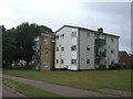
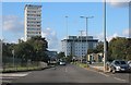
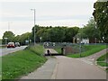
Photos of SG1 1ST


Area Information
Living in SG1 1ST offers a distinct residential experience defined by its small scale and established character. This specific postcode cluster covers an area of 1,609 square metres, which contradicts typical definitions of a neighbourhood and suggests a very concentrated housing density. Despite the physical size, the population stands at 1,699 people. This concentration creates a neighbourhood that feels close-knit while remaining part of the wider Stevenage settlement. Residents here benefit from immediate access to major rail links and supermarket chains without needing to traverse long distances for daily essentials. The built environment consists primarily of houses rather than flats, catering to those seeking detached or semi-detached living. With a high household ownership rate, the area feels settled rather than transient. Families appreciate the proximity to Broom Barns Primary School, while commuters value the short walk or drive to Stevenage Railway Station. You will find that daily life revolves around practical convenience rather than sprawling infrastructure. The location avoids significant planning constraints such as protected woodlands or AONB status, meaning the landscape is designed primarily for habitation. This makes SG1 1ST an ideal choice for buyers prioritising straightforward access to transport hubs and retail outlets within a compact yet complete living environment.
- Area Type
- Postcode
- Area Size
- 1609 m²
- Population
- 1699
- Population Density
- 2693 people/km²
The property market in SG1 1ST is characterised by a strong emphasis on ownership rather than renting. With 55 per cent of residents owning their homes, this area leans heavily towards the owner-occupied sector. The predominant accommodation type comprises houses, meaning you will find a stock of bungalows, semi-detached, and detached properties rather than high-density apartments. This housing mix supports families who require garden space and private entrances. Because this is a small residential cluster covering only 1,609 square metres, the variety of property sizes is likely limited compared to larger town districts. Buyers looking for flats or parks will need to look beyond the immediate SG1 1ST boundary. The high ownership figure suggests that properties here tend to stay with families for extended periods, reducing tenant turnover and eviction risks for landlords. If you are purchasing a home in this postcode, expect a market driven by long-term residents upgrading or consolidating their assets. The concentration of houses means prices may reflect the specific location and condition of individual estates. This stability makes SG1 1ST attractive to investors seeking solid, owner-occupied assets rather than volatile buy-to-let opportunities in student lounges.
House Prices in SG1 1ST
Showing 5 properties
| Address | Type | Beds | Baths | Last Sale Price | Last Sale Date | |
|---|---|---|---|---|---|---|
| 5 Lindens, Stevenage, SG1 1ST | Terraced | 2 | 1 | £166,000 | May 2014 | |
| 3 Lindens, Stevenage, SG1 1ST | Terraced | - | - | £157,500 | Aug 2008 | |
| 9 Lindens, Stevenage, SG1 1ST | Terraced | - | - | £75,000 | Jan 2001 | |
| 7 Lindens, Stevenage, SG1 1ST | house | - | - | - | - | |
| 1 Lindens, Stevenage, SG1 1ST | Terraced | - | - | - | - |
Energy Efficiency in SG1 1ST
Residents of SG1 1ST enjoy a lifestyle defined by immediate access to essential retail and transport nodes. Within practical reach, you will find five retail outlets including Asda Stevenage, Morrisons Daily, and Iceland Stevenage. These supermarkets cover your weekly shopping needs for groceries, household necessities, and frozen foods. For rail travel, five stations are nearby, with Stevenage Railway Station being the most prominent commuter hub. Knebworth and Watton stations offer additional flexibility for regional travel. This concentration of amenities means you do not need a car for every daily trip. Supermarkets are only a short distance away, making this neighbourhood particularly convenient for families and elderly residents. The lack of listed parks or specific leisure venues in the immediate data suggests that entertainment options are found in the wider Stevenage town centre or suburban parks beyond the postcode. However, the presence of major high-street supermarkets provides a solid foundation for socialising and running errands. Living in SG1 1ST means your daily routine revolves around these accessible, large-format stores and efficient rail connections.
Amenities
Schools
Education provision for children living in SG1 1ST is anchored by a single primary institution listed in the immediate vicinity. Broom Barns Primary School is the only named school provided for this specific area. It is rated as 'good' by Ofsted, which places it in the second-highest possible rating category alongside outstanding schools. As a primary school, it caters to children aged approximately four to eleven years old. Parents in this postcode have direct access to a school with a proven track record of educational quality. Secondary education options are not listed within the immediate data for SG1 1ST, suggesting children frequently board at schools further away from the cluster. This arrangement is typical for smaller residential clusters that feed into larger local authority catchment areas. The presence of a 'good' rated primary school ensures that young learners start their education journey in a supportive and academically sound environment. Families valuing reputable primary education will find SG1 1ST to be a viable location. The absence of other listed nearby schools indicates a reliance on the local primary intake before moving to secondary institutions elsewhere.
| Rank | School | Type | Entry gender | Ages |
|---|
Explore more schools in this area
Go to Schools tabDemographics
The community within SG1 1ST reflects a mature and financially stable demographic profile. The median age is 47, with the most common age range falling between 30 and 64 years. This indicates a population dominated by working adults and established families rather than a youth-heavy or elderly enclave. Home ownership stands at 55 per cent, signalling that more than half the residents have bought their property outright or via mortgage. The predominant form of accommodation is houses, which aligns with the preference of this age group for single-storey or two-storey family dwellings over flats. Ethnically, the area is predominantly White, contributing to a homogeneous community atmosphere. You are likely to encounter neighbours who have lived in the district for many years, fostering a sense of local knowledge and stability. The lack of significant deprivation data implies a consistent standard of living across the postcode. This demographic makeup suggests a quiet environment where children play safely and older residents enjoy a gentle retirement. The high proportion of adults aged 30 to 64 years also means that local businesses catering to families and commuters thrive. Living in SG1 1ST provides a snapshot of suburban England at a stable stage of development.
Household Size
Accommodation Type
Tenure
Ethnic Group
Religion
Household Composition
Age
Household Deprivation
NS-SEC
Explore more demographic insights in this area
Go to Demographics tabPlanning
Planning Constraints
- Flood RiskPremium
- Ramsar Wetland SitesPremium
- Area of Outstanding Natural BeautyPremium
- Protected Nature ReservePremium
- Protected WoodlandPremium