Area Overview for Potters Bar Furzefield Ward
Photos of Potters Bar Furzefield Ward


Area Information
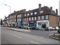
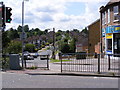
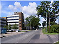
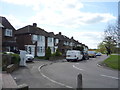
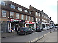
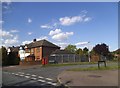
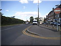
Living in Potters Bar Furzefield Ward offers access to a compact community spanning just 4.5 km² within Hertfordshire. This electoral ward sits approximately 13 miles north of central London, placing it firmly within the commuter belt. The area acts as a functional part of the broader town of Potters Bar in the borough of Hertsmere. Key landmarks include the Furzefield Centre near the EN6 3BW postcode and King Georges Field across the Cranborne Road boundary. The ward includes the town's swimming pool and leisure centre, operated by Hertsmere Borough Council. You will find the area bordered by Cranbourne Avenue, linking local residential streets to the wider road network. Historical roots date back to the early 13th century when the settlement served as a point on the Great North Road. The Great Northern Railway arrival in 1850 transformed the local economy. Residential life here is shaped by this accessible location and established infrastructure. The average resident enjoys proximity to Potters Bar railway station, located roughly 1 kilometre from certain parts of the ward. This transport hub serves regular London commuter routes. The M25 motorway provides access at junctions 23 and 24, while the A1000 connects local areas to the main A1 road.
- Area Type
- District Borough Unitary Ward
- Area Size
- 4.5 km²
- Population
- Not available
- Population Density
- Not available
Demographics
The community in Potters Bar Furzefield Ward has an older population profile compared to the national average. The median age stands at 70 years, reflecting a significant number of residents in their later years. While the provided data does not specify the most common age range in detail beyond a generic "Total" label, the high median age indicates a demographic focused on retirement or mature living. Home ownership is the standard here, with 68% of residents owning their homes outright. This high figure suggests families have built long-term ties to the locality. Household composition varies across the ward, though specific breakdowns for single-person households versus families are not detailed in the current statistics. The ward encompasses a mix of accommodation types, typical of towns that have evolved over centuries. Ethnic diversity and religious affiliation figures for the total population are not explicitly listed in the available dataset. Instead of focusing on broad categorisations, the area remains defined by its established residential character. This demographic spread means the local shops and services cater to mature tastes while maintaining essential community facilities.
Household Size
Accommodation Type
Tenure
Ethnic Group
Religion
Household Composition
Age
Household Deprivation
NS-SEC
Explore more demographic insights in this area
Go to Demographics tabPlanning
Planning Constraints
- Flood RiskLocked
- Ramsar Wetland SitesLocked
- Area of Outstanding Natural BeautyLocked
- Protected Nature ReserveLocked
- Protected WoodlandLocked
- Crime RiskLocked