Area Overview for PE32 1RL
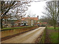
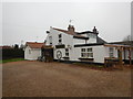
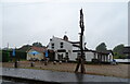
Photos of PE32 1RL


Area Information
Living in PE32 1RL means residing in a specific residential cluster covering 3.9 hectares. This postcode area hosts a population of 1469 people, creating a defined but manageable community environment. The settlement functions as a small neighbourhood where residents experience close proximity to one another within a compact footprint. You are part of a locality with a distinct identity, separate from the wider Kings Lynn region yet integrated into its broader transit network. Daily life here is shaped by the concentration of households occupying a relatively small geographical space. The area provides a settled context for families and individuals seeking a lower-density existence compared to the city centre. Your location offers direct access to key services surrounding the Kings Lynn hub while maintaining the privacy that comes with a small residential cluster. The compact nature of the site means you are likely aware of your immediate neighbours and the general rhythm of the street. This is a place where the scale of the community allows for a focused lifestyle without the overwhelming bustle of a larger urban district. The environment is characterised by stability and a clear sense of place within the wider East of England housing market.
- Area Type
- Postcode
- Area Size
- 3.9 hectares
- Population
- 1469
- Population Density
- 113 people/km²
The housing stock in PE32 1RL is defined by its composition of houses and a high rate of ownership. Since 80% of properties are owner-occupied, the market here is driven by existing homeowners rather than transient tenants seeking rental accommodation. This high ownership percentage indicates that you are looking at a area where families have invested in long-term security and stability. Accommodation types are exclusively houses, meaning you can expect traditional housing forms without the option of urban flats or bungalows designated as social rental blocks. The small area size of 3.9 hectares suggests a limited supply of available properties, which can influence local pricing dynamics and resale times. Buyers considering this area are entering a market with clear characteristics where the housing model is firmly established around private ownership. This structure supports a quiet street life and reduces the turnover typically associated with high-rent estates. When evaluating homes in PE32 1RL, you should anticipate finding well-established residences suited to the needs of adults aged 30 to 64 years. The market here does not cater to the needs of first-time buyers looking for urban density or rental flexibility, but rather serves the secondary or upgrade market.
House Prices in PE32 1RL
No properties found in this postcode.
Energy Efficiency in PE32 1RL
Your lifestyle in PE32 1RL benefits from the convenience of several retail outlets and transport hubs located within practical reach. Residents have access to Sainsburys Kings, Iceland Kings, and Tesco Kings for their shopping needs, ensuring daily essentials are a short drive away. For commuters, Kings Lynn Railway Station and Watlington Railway Station provide rail links to wider destinations. If you require maritime travel, the area includes King's Lynn Ferry Landing and West Lynn Ferry Landing, offering alternative transport routes across the water. Five retail outlets are situated nearest to the postcode, providing a range of goods without needing to travel far into the city centre. The combination of rail and ferry services integrates this residential cluster into the broader East of England transport network. You do not need to leave the region for groceries or supermarket shopping, as the major chains are named and confirmed within easy reach. These amenities support a self-sufficient daily routine where you can manage family errands and light travel requirements locally.
Amenities
Schools
Parents living in PE32 1RL have access to two primary schools located within a practical commuting distance. Middleton Voluntary Controlled Primary School stands as the first option for families residing in this postcode. A second choice is Middleton Church of England Primary Academy, which you must evaluate carefully as its Ofsted rating is inadequate. This specific rating indicates that the academy requires significant improvement and that you should scrutinise its recent performance reports before committing your children to it. The presence of only primary institutions means that older children and teenagers will need to travel to schools outside this immediate vicinity for secondary education. Families with young children must weigh the options provided by these two specific titles, bearing in mind the mixed quality available. The educational landscape in and around PE32 1RL is narrow, lacking a broad selection of graded institutions within the immediate walking distance. You should plan your daily route accordingly, as the inadequate rating of one of the local options may necessitate transporting your child to a different school further away.
| Rank | School | Type | Entry gender | Ages |
|---|---|---|---|---|
| 1 | Middleton Voluntary Controlled Primary School | primary | N/A | N/A |
| 2 | Middleton Church of England Primary Academy | primary | N/A | N/A |
Explore more schools in this area
Go to Schools tabDemographics
The community in PE32 1RL is dominated by a population with a median age of 47 years. Most residents fall into the adult age range of 30 to 64 years, indicating a settlement composed primarily of established adults. This demographic profile suggests a neighbourhood where long-term residents and older families are the norm rather than young professionals or students. Accommodation types in the area consist almost entirely of houses, meaning flats and urban apartments are not a feature of this postcode. You will find a stable population where 80% of homes are owner-occupied, reflecting a high level of settlement and investment in the local area. The predominant ethnic group is White, which aligns with the eastern counties of England where this cluster is located. There is no significant young population, and the absence of rental households points towards a conservative, sell-on-settle market. The demographic composition suggests a quiet environment where residents have likely settled down and put down deep roots in the Kings Lynn postcode zone. You are surrounded by people of similar age and life stage, which can foster a tight-knit social fabric within the 1469 residents.
Household Size
Accommodation Type
Tenure
Ethnic Group
Religion
Household Composition
Age
Household Deprivation
NS-SEC
Explore more demographic insights in this area
Go to Demographics tabPlanning
Planning Constraints
- Flood RiskPremium
- Ramsar Wetland SitesPremium
- Area of Outstanding Natural BeautyPremium
- Protected Nature ReservePremium
- Protected WoodlandPremium
- Crime RiskPremium