Area Overview for PE2 9NR
Photos of PE2 9NR


Area Information
Living in PE2 9NR, a small residential cluster in England, offers a specific experience defined by its compact footprint and mature residents. This postcode covers 4.2 hectares and is home to 2,624 people, creating a tightly knit environment. The area is characterised by a high population density of 62,966 people per square kilometre. Such density, combined with a median age of 47, suggests a neighbourhood settled by established families rather than young urbanites. You will find a community where daily life moves at a steady pace, focused largely on household stability. The accommodation is primarily houses, shaping the streetscape away from high-rise living. This demographic profile means PE2 9NR functions more as a suburban extension than a bustling town centre. For buyers considering homes in this specific postcode, the reality is a quiet, residential setting. The area does not cater to a youthful nightlife or dynamic commercial scene. Instead, it provides a solid foundational base for families prioritising space and proximity to key services without the chaos of city life. Understanding this balance is essential for anyone looking to settle here.
- Area Type
- Postcode
- Area Size
- 4.2 hectares
- Population
- 2624
- Population Density
- 4527 people/km²
The property market in PE2 9NR is defined by a strong preference for traditional housing. Houses are the standard accommodation type, meaning you will search primarily among detached or semi-detached properties rather than flats or conversions. Home ownership stands at 43%, placing this locality firmly within the mix of owner-occupiers and renters. This split suggests a balanced market where investment buyers and first-time movers can both find opportunities, though the stock is likely skewed towards existing families. Given the small size of the postcode, covering just 4.2 hectares, inventory turnover may be lower than in larger districts. Buying a home in PE2 9NR often requires acting quickly, as supply is finite. The prevalence of houses implies higher price points compared to flat markets, dependent on floor space and garden size. You should not expect sprawling high-density developments here. Instead, focus on plot orientation and local maintenance standards. The 43% ownership rate also signals a resale market that values long-term stability. Leasehold issues are less likely to dominate your search than you might find in London-centric areas. Ultimately, the market reflects a functional, family-oriented housing stock.
House Prices in PE2 9NR
Showing 1 properties
| Address | Type | Beds | Baths | Last Sale Price | Last Sale Date | |
|---|---|---|---|---|---|---|
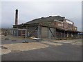
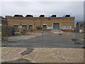
| Riverside Cafe, Railworld, Oundle Road, Woodston, Peterborough, PE2 9NR | Restaurant | - | - | - | - |
Energy Efficiency in PE2 9NR
Your daily life in PE2 9NR benefits from convenient access to major local hubs within practical reach. Petersborough, Orton Mere, and Ferry Meadows serve as key metropolitan destinations for your weekly trips. Retail needs are easily met by five nearby outlets, including Asda Peterborough, Tesco Peterborough, and Waitrose Peterborough. These supermarkets ensure you can stock up on groceries without long travel times. Transport links are supported by two railway stations located nearby: Peterborough Railway Station and Whittlesea Railway Station. This rail access provides a straightforward route to wider professional networks beyond the immediate cluster. While PE2 9NR is not a shopping district itself, its proximity to these amenities means you do not live in isolation. A trip to Waitrose or the main station requires a short journey rather than hours of commuting. This balance of privacy and access defines the lifestyle here. You enjoy a quiet residential environment while retaining easy footprints into broader commercial zones for entertainment and work.
Amenities
Schools
Families in PE2 9NR have access to two local primary institutions. Brewster Avenue Infant School serves the reception to Year 2 age group and holds a Good Ofsted rating. Residents also have immediate access to St Augustine's CofE (Voluntary Aided) Junior School, which covers Years 3 to 6. Both schools share the same positive Ofsted rating of Good. This dual-school arrangement means children can complete their primary education within the local network without needing to travel far for transport. The specific mix of an infant school and a CofE junior school provides options for parents differing in religious affiliation. Living in PE2 9NR places your school-aged children within a short commute to these established facilities. The consistency in ratings between the two suggests a reliable educational environment for the neighbourhood. You do not have to look beyond these premises for primary education choices. Both institutions contribute to the area's appeal for families with young children. The presence of two Good-rated schools nearby is a significant asset when evaluating homes in this postcode.
| Rank | School | Type | Entry gender | Ages |
|---|
Explore more schools in this area
Go to Schools tabDemographics
The community in PE2 9NR is distinctively mature, with 43% of residents owning their homes outright or with a mortgage. This ownership level indicates a stable population invested in the locality. The most common age range spans adults between 30 and 64 years old, reinforcing the area's appeal to those mid-career or raising school-aged children. You are unlikely to find a party-going crowd here, as the median age sits at 47. Meanwhile, houses remain the predominant accommodation type, reflecting preferences for space over urban units. Ethnically, the population is predominantly White, contributing to a homogeneous social fabric. There is no indication of significant multicultural inequalities within the provided data. Deprivation metrics are not detailed, but the low level of rented accommodation and high home ownership suggest a settled upper-middle or working-class demographic. This profile matters for understanding neighbourhood dynamics. Childcare and social groups likely reflect this middle-age skew. Younger professionals or retirees under 30 may feel less of a home here compared to their counterparts in 50-year-old suburbs. The demographic facts show a workplace family corridor rather than a retirement haven or student quarter.
Household Size
Accommodation Type
Tenure
Ethnic Group
Religion
Household Composition
Age
Household Deprivation
NS-SEC
Explore more demographic insights in this area
Go to Demographics tabPlanning
Planning Constraints
- Flood RiskPremium
- Ramsar Wetland SitesPremium
- Area of Outstanding Natural BeautyPremium
- Protected Nature ReservePremium
- Protected WoodlandPremium