Area Overview for NR33 7BP
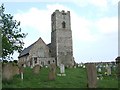
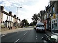
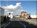
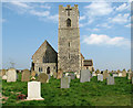
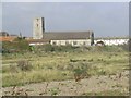
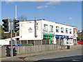
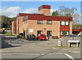
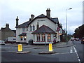
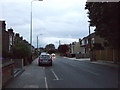
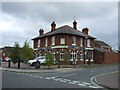
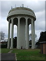
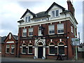
Photos of NR33 7BP
Area Information
NR33 7BP represents a specific postcode area covering a small residential cluster in England. This locality supports a population of 1547 residents who call it home. You will find this postcode situated within a dedicated residential zone rather than a sprawling commercial district. The area defines itself through its compact nature and distinct housing identity. Living in NR33 7BP means engaging with a community where houses form the predominant accommodation type. The daily rhythm here revolves around a tight-knit group of people who have established permanent ties to the location. This small cluster offers a focused living environment where neighbours often know one another. You navigate this space with an understanding that it is a self-contained residential pocket separated from larger urban centers by clear boundaries. The character of the area remains defined by its population size and the specific layout of the houses within the postcode boundary. Prospective buyers view NR33 7BP as a contained environment rather than a large town or city district.
- Area Type
- Postcode
- Area Size
- Not available
- Population
- 1547
- Population Density
- 2276 people/km²
The property market in NR33 7BP skews heavily towards permanent homeownership rather than the rental sector. You will find that 79 percent of the population owns their homes. This statistic reveals a market characterised by stability and long-term residency rather than short-term letting arrangements. Houses dominate the accommodation profile throughout the cluster, shaping the visual landscape and street furniture of the neighbourhood. This means you are purchasing a permanent asset designed for extended living rather than a temporary home. The dominance of owner-occupiers influences local decisions regarding property maintenance and community appearance. Buyers looking at this small area should expect a stock focused on traditional housing types suited for families. The high ownership rate suggests that when properties do come up for sale, they tend to move within a network of existing stakeholders or offer genuine value to newcomers. This environment discourages speculative buying and fosters a reliable market where residents build equity over years rather than months.
House Prices in NR33 7BP
No properties found in this postcode.
Energy Efficiency in NR33 7BP
Residents of NR33 7BP benefit from a practical range of amenities within easy reach. You have access to five retail locations, including the Co-op Pakefield, Aldi Gateway, and Morrisons Pakefield. These supermarkets and shops handle most of your daily grocery and household needs without requiring long journeys. Five rail-related entrance points and stations, such as Oulton Broad South Railway Station, provide structured transport access. Beccles Airport stands as a nearby facility for wider travel requirements. This concentration of retail and transport nodes creates a convenient lifestyle where errands are quick and manageable. The presence of major high-street brands like Aldi and Morrisons indicates a reliable supply chain for fresh food and essentials. You do not face significant travel times to obtain basic services. The area functions well as a self-contained unit for shopping and transit.
Amenities
Schools
Pakefield Primary School stands as the key educational institution nearest to NR33 7BP. This primary school holds an Ofsted rating of Good, indicating a standard of education that meets the required benchmarks. Families with young children in NR33 7BP benefit from having this rated school in close proximity. The presence of a single primary school suggests that the local area caters specifically to younger demographics before children move on to secondary institutions outside the immediate cluster. You do not have secondary schools listed within this specific dataset for this postcode, meaning older children likely travel further for education. The Good rating for Pakefield Primary School provides reassurance to parents seeking quality instruction locally. This school serves as a central community fixture for the residents of this postcode area.
| Rank | School | Type | Entry gender | Ages |
|---|
Explore more schools in this area
Go to Schools tabDemographics
Adults aged between 30 and 64 years constitute the most common age range within the demographic profile of NR33 7BP. This cluster is slightly older overall, with a median age of 47 years. You will encounter a community where stability is the norm, reflected in a home ownership rate of 79 percent. This figure indicates that the vast majority of residents live in the homes they own outright or are paying for. Houses make up the primary form of accommodation throughout the cluster. The predominant ethnic group in the area identifies as White. Eighty-one percent of crime risk assessments place this neighbourhood in the safe category, confirming it has below-average crime rates. This environment suits families and professionals seeking a settled pace of life. The high proportion of owner-occupiers combined with the mature age profile suggests long-term residents rather than transient tenants. You do not experience high turnover here, as most households have embedded roots.
Household Size
Accommodation Type
Tenure
Ethnic Group
Religion
Household Composition
Age
Household Deprivation
NS-SEC
Explore more demographic insights in this area
Go to Demographics tabPlanning
Planning Constraints
- Flood RiskPremium
- Ramsar Wetland SitesPremium
- Area of Outstanding Natural BeautyPremium
- Protected Nature ReservePremium
- Protected WoodlandPremium