Area Overview for NR33 0HD
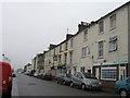
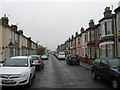
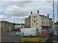
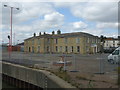
Photos of NR33 0HD


Area Information
Living in NR33 0HD offers a quiet residential experience within a tightly knit cluster of homes. This specific postcode serves approximately 1,408 people, creating a close-knit environment where neighbours know each other. You will find this location appeals to those seeking a settled community rather than a bustling urban centre. The area functions as a practical base for daily life, with residents able to access local services and transport links without leaving the immediate vicinity. Your routine revolves around a small community where the pace of life remains steady. The existence of nearby amenities ensures you do not need to travel far for essential shopping or daily errands. You gain peace of mind knowing your home sits in a developed residential zone with established infrastructure. The distinct identity of NR33 0HD comes from its focus on housing over commercial high streets. Daily life here is defined by proximity to key local hubs like Lowestoft and Oulton Broad. You will discover that this area supports a traditional way of living. The compact nature of the postcode means that distances to shops and stations remain manageable for residents. You can walk or drive quickly to the world nearby while maintaining a sense of privacy at home. This setting suits individuals who prioritise stability and community over anonymity. The area presents a straightforward choice for those wanting a specific slice of Suffolk life.
- Area Type
- Postcode
- Area Size
- Not available
- Population
- 1408
- Population Density
- Not available
The property market in NR33 0HD is characterised by established ownership and a specific housing stock. Houses dominate the local landscape, meaning you will primarily find traditional residential properties rather than flats or conversions. This preference for detached or semi-detached homes aligns with the wider pattern found in the postcode. The home ownership rate sits at 51%, indicating that just over half of all properties are owner-occupied. You are likely to encounter owners who plan to stay in the area for the long term. This market structure reduces the volume of short-term letting you might face as a new resident. The housing stock reflects the needs of the local workforce and families who settled here years ago. Buying into this market means joining a community of established homeowners who value their addresses. The limited variety in property types means you can expect uniformity in building styles and garden sizes. Your search for homes in NR33 0HD should focus on the traditional house formats common to this demographic. The area does not cater to high-density living or student housing demands. Instead, it supports families and individuals seeking a standard suburban lifestyle. Prices and availability will reflect these specific constraints and the strong ownership culture. You find a market defined by permanence and traditional property values.
House Prices in NR33 0HD
No properties found in this postcode.
Energy Efficiency in NR33 0HD
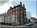
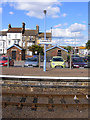
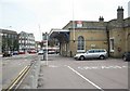
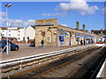
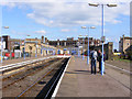
Your lifestyle in NR33 0HD benefits from practical access to key retail and transport hubs. Five major amenities lie within reach, including Co-op Kirkley, Asda Lowestoft, and Iceland Lowestoft. These supermarkets provide all the shopping essentials you require without needing to travel to larger towns. You can handle your weekly grocery runs and household shopping from these local favourites. Transport options extend beyond cars, with five railway stations nearby. Lowestoft Railway Station, Entrance, and Oulton Broad North Railway Station offer reliable rail connections for commuting or weekend getaways. You might also use Beccles Airport for specific travel needs, adding another layer of connectivity to your options. These facilities mean you do not have to be isolated from the wider region. Your daily routine wins on convenience because essential services come within realistic travel distance. The combination of retail outlets and train stations creates a balanced lifestyle. You gain the privacy of a small residential cluster with the convenience of larger town amenities. This balance defines the character of living in the NR33 0HD postcode area.
Amenities
Schools
Families living in NR33 0HD have access to three notable schools within the immediate vicinity. Fen Park Community Primary School operates as a primary institution for the local community. You can also send your children to Kirkley Middle School, which serves the same primary education level. Red Oak Primary School stands out with a good Ofsted rating, reflecting a positive educational standard. The mix of school types allows you to choose education based on your specific preferences for pedagogy or location. All three facilities cater to early years and primary education needs. This concentration of primary schools means you will find consistent schooling options right near your home. You do not need to commute further away for primary education in most cases. The presence of these institutions supports the family-oriented demographic found in the postcode. If you value a high-rated local option, Red Oak Primary School offers a verified standard of teaching. The other two schools provide additional choices within the same catchment area. You benefit from a selection of primary providers without needing to look beyond the local neighbourhood. The school infrastructure directly supports the resident age profile of the area. Your children can start their education journey walking through the gates of familiar local schools.
| Rank | School | Type | Entry gender | Ages |
|---|
Explore more schools in this area
Go to Schools tabDemographics
The community in NR33 0HD reflects a settled population with a median age of 47. Most residents fall within the 30 to 64 years age range, indicating a neighbourhood dominated by working adults and mature families. This age profile suggests stability rather than rapid turnover of residents. You will find that 51% of households in this postcode own their homes outright. This majority indicates a strong culture of home ownership rather than a transient rental market. The local accommodation consists almost entirely of houses, offering traditional family living arrangements for those who purchase. The predominant ethnic group in the area is White, contributing to a familiar and established local culture. You live in an environment where generations often stay in the same streets. The demographic makeup supports a community driven by long-term residents who value their property. There is little evidence of high youth migration or seasonal population shifts. The population structure suggests you are joining a community of established neighbours who have rooted themselves in the locality. This stability extends to the day-to-day interactions and neighbourly relations you will experience. Your life here aligns with the rhythms of established households rather than temporary dwellers. The area attracts those seeking a consistent social environment.
Household Size
Accommodation Type
Tenure
Ethnic Group
Religion
Household Composition
Age
Household Deprivation
NS-SEC
Explore more demographic insights in this area
Go to Demographics tabPlanning
Planning Constraints
- Flood RiskPremium
- Ramsar Wetland SitesPremium
- Area of Outstanding Natural BeautyPremium
- Protected Nature ReservePremium
- Protected WoodlandPremium