Area Overview for NR33 0DR
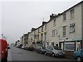
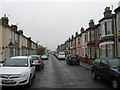
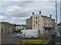
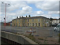
Photos of NR33 0DR


Area Information
Living in NR33 0DR means residing within a highly concentrated residential cluster defined by a specific postcode in England. This area covers just 5,024 square metres, hosting a total population of 1,598 people. The density here creates an environment where residents are situated very closely together, resulting in a figure of 318,078 people per square kilometre. This statistical anomaly underscores that the provided data describes a specific, small-scale neighbourhood rather than a standalone town district. Daily life involves navigating compact streets where proximity is the primary defining feature of the locality. You will find that the community is tightly knit due to the limited physical footprint of the housing estate. While the area lacks the vast space of a larger municipality, the high population concentration ensures immediate access to local neighbours and shared community resources. Prospective buyers should view this address as a precise location within a broader Lowestoft context rather than an isolated pocket. The character of the area is shaped by its intensive land use, making every home feel part of a larger urban fabric despite the official classification as a small residential cluster. Understanding this scale is essential before viewing properties in this specific postcode.
- Area Type
- Postcode
- Area Size
- 5024 m²
- Population
- 1598
- Population Density
- 318078 people/km²
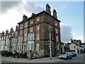
The property market in NR33 0DR is characterised by a distinct rental sector, evidenced by the fact that only 25% of residents own their homes. This low homeownership rate indicates that the majority of housing stock is available to tenants rather than freeholders. The predominant accommodation type in this postcode is flats, which aligns with the mature age profile of the population. You are looking at a market where investors may dominate the supply side, given the high rental occupancy. This structure means that buyers seeking freehold detached houses here must look beyond the immediate NR33 0DR boundaries. The housing stock is tailored to the demographic reality of adults aged 30 to 64. If you plan to purchase a home in this area, you should expect to engage with a landlord-heavy market. The concentration of flats suggests a focus on density and accessibility rather than detached family homes. Prospective owners need to understand that the local economy supports this rental volume. The specific nature of the flats means that maintenance responsibilities and communal arrangements differ from typical suburban housing. This market dynamic creates a unique opportunity for those willing to navigate the rental landscape or purchase specifically for the flat market.
House Prices in NR33 0DR
Showing 25 properties
| Address | Type | Beds | Baths | Last Sale Price | Last Sale Date | |
|---|---|---|---|---|---|---|
| 193A London Road South, Lowestoft, NR33 0DR | undefined | - | - | £40,000 | Mar 2015 | |
| Proposed Dwelling Rear Of, 189 London Road South, Lowestoft, NR33 0DR | Other | - | - | £70,000 | Oct 2004 | |
| First Floor And Second Floor, 175 London Road South, Lowestoft, NR33 0DR | Flat | 3 | 1 | - | - | |
| 169D London Road South, Lowestoft, NR33 0DR | Flat | - | - | - | - | |
| 181B London Road South, Lowestoft, NR33 0DR | undefined | - | - | - | - | |
| 191A London Road South, Lowestoft, NR33 0DR | Maisonette | 2 | 1 | - | - | |
| 183C London Road South, Lowestoft, NR33 0DR | Flat | - | - | - | - | |
| 181C London Road South, Lowestoft, NR33 0DR | undefined | - | - | - | - | |
| 173A London Road South, Lowestoft, NR33 0DR | Land | 3 | - | - | - | |
| 171A London Road South, Lowestoft, NR33 0DR | undefined | - | - | - | - |
Energy Efficiency in NR33 0DR
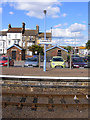
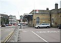
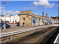
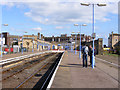
Your lifestyle as a resident of NR33 0DR is defined by close proximity to key amenities in Lowestoft and surrounding towns. Five notable shopping venues operate within practical reach, including Co-op Kirkley, Asda Lowestoft, and M&S Lowestoft. These retail options provide comprehensive access to essential goods, fresh food, and household necessities. Beyond shopping, rail transport is easily accessible with five nearby stations, specifically Lowestoft Railway Station, Oulton Broad North Railway Station, and various entrances. This rail network facilitates easy commuting to broader employment hubs. You can also reach Beccles Airport, located just one venue away, offering regional air travel connections. This transport mix ensures you can travel by car, train, or air with minimal effort. Shopping remains a central part of daily routine at Co-op Kirkley and Asda. The presence of these specific retailers means you rarely need to travel far for daily purchases. Dining and leisure options are integrated into the walking distance of these main stations. The convenience of having Asda and M&S within reach simplifies household management. The rail connectivity to Lowestoft Railway Station supports both daily commutes and weekend trips outside the immediate area. This amenity density compensates for the small physical size of the postcode area. You enjoy a balance of urban convenience without the sprawling distances of larger cities.
Amenities
Schools
| Rank | School | Type | Entry gender | Ages |
|---|
Explore more schools in this area
Go to Schools tabDemographics
The community in NR33 0DR presents a mature demographic profile dominated by adults between the ages of 30 and 64 years. The median age for residents sits at 47, indicating that the population skews towards middle age and older adulthood. You will find predominantly owner-occupied households, though there is a notable split where only 25% of residents own their homes outright. The remaining majority rent with an eight-week possession period. This high rental ratio suggests a significant section of the community may be tenants rather than long-term owners. The population stability is further reflected in the accommodation type, which consists primarily of flats. These properties cater to the age profile of the residents. The ethnic composition is predominantly White, forming the majority of the local population. With 1,598 people living in such a small area, the demographic mix is concentrated. The age data confirms that families and established professionals form the core of this community. You can expect an environment where the residents have established themselves in the area. The high proportion of adults in this bracket implies a demand for accessible housing solutions like flats.
Household Size
Accommodation Type
Tenure
Ethnic Group
Religion
Household Composition
Age
Household Deprivation
NS-SEC
Explore more demographic insights in this area
Go to Demographics tabPlanning
Planning Constraints
- Flood RiskPremium
- Ramsar Wetland SitesPremium
- Area of Outstanding Natural BeautyPremium
- Protected Nature ReservePremium
- Protected WoodlandPremium