Area Overview for NR32 1DX
Photos of NR32 1DX


Area Information
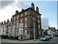
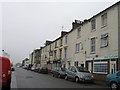
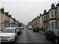
NR32 1DX is a small residential cluster located in England with a population of 2,032. You will find this area defined by its compact size rather than expansive geography. It serves as a focused living space for several hundred households within the broader Lowestoft region. Daily life here revolves around proximity to essential services rather than extensive local sprawl. Residents enjoy a close-knit environment where neighbours are likely to know one another due to the limited population. This postcode covers a specific area where the community functions with a manageable scale. You can expect a setting that prioritises direct access to utility networks and transport links over extensive local amenities. The area acts as a practical base for those who need a foothold in the district without navigating a sprawling urban landscape. Living in NR32 1DX offers a streamlined existence where distance to key facilities remains short. The layout supports a lifestyle centred on efficiency and direct connectivity to the surrounding towns.
- Area Type
- Postcode
- Area Size
- Not available
- Population
- 2032
- Population Density
- 5961 people/km²
Homes in NR32 1DX are primarily identified as houses, which shapes the character of the local housing stock. The area does not feature a concentration of flats or high-density apartment blocks. With home ownership recorded at 30%, you should anticipate a market where rental demand may compete strongly with purchase opportunities. A third of all residents own their property outright or with a mortgage, while the remaining seven tenths likely reside in rentals. This imbalance affects the stability of the tenant base and the turnover rate of homes on the private market. The low ownership percentage often correlates with a reliance on private sector landlords or social housing providers. Buyers looking for a permanent stake in the area may find the purchase ladder more challenging than in more affluent pockets. The accommodation types available are restricted to house structures, limiting options for those seeking modern complexes. Consequently, the property market here operates with fewer inventory choices compared to mixed-use districts.
House Prices in NR32 1DX
No properties found in this postcode.
Energy Efficiency in NR32 1DX
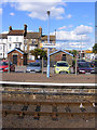
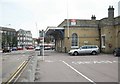
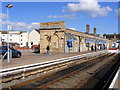
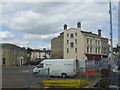
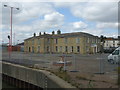
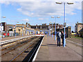
Local amenities are situated within practical reach of NR32 1DX, offering convenience for weekly shopping and daily errands. Five railway stations surround the area, including Entrance, Lowestoft Railway Station, and Oulton Broad North Railway Station, facilitating easy rail travel beyond the immediate postcode. Retail availability is solid with five notable supermarkets and convenience stores nearby. You can access M&S Lowestoft, Iceland Lowestoft, and Tesco Lowestoft for all your grocery and household requirements without travelling far. These major retailers ensure that your shopping trips are quick and efficient. The presence of these high-profile stores suggests a well-serviced environment where essential goods are always in stock. While fewer leisure-specific venues are listed in the immediate proximity, the rail network expands your accessible lifestyle radius significantly. Residents can easily reach larger town centres for dining, leisure, and specialist shopping by connecting to the nearest railway lines. Daily life balances local accessibility with the option to travel to wider regional hubs when desired.
Amenities
Schools
| Rank | School | Type | Entry gender | Ages |
|---|
Explore more schools in this area
Go to Schools tabDemographics
The community in NR32 1DX reflects a mature residential profile with a median age of 47 years. Most residents fall into the adults age range between 30 and 64 years, indicating a household base dominated by working-age professionals and families. You will encounter a population that has largely established themselves within the local housing stock. White residents form the predominant ethnic group in this area. Home ownership stands at 30%, which implies that the majority of occupants live in rented accommodation or maintain shared ownership arrangements. This statistic suggests a significant portion of the population may be tenants rather than property owners. Unlike areas with high ownership rates, you will find fewer families with long-term generational ties to specific plots of land. The demographic data points to a transient or semi-transient settlement pattern common in commuter belts. Safety assessments indicate a high crime risk with a score of 1 out of 100, a factor that influences the social dynamics of this neighbourhood.
Household Size
Accommodation Type
Tenure
Ethnic Group
Religion
Household Composition
Age
Household Deprivation
NS-SEC
Explore more demographic insights in this area
Go to Demographics tabPlanning
Planning Constraints
- Flood RiskPremium
- Ramsar Wetland SitesPremium
- Area of Outstanding Natural BeautyPremium
- Protected Nature ReservePremium
- Protected WoodlandPremium