Area Overview for NR29 4JJ
Photos of NR29 4JJ
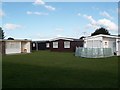
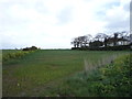
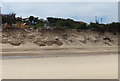
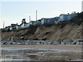
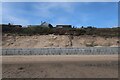
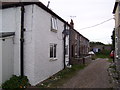
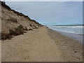
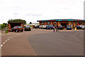
19 photos from this area
Area Information
Key information about the NR29 4JJ including its size, population, and administrative classification.
- Area Type
- Postcode
- Area Size
- 1.2 hectares
- Population
- 1769
- Population Density
- 874 people/km²
House Prices in NR29 4JJ
12
Properties
£165,356
Average Sold Price
£65,000
Lowest Price
£375,995
Highest Price
Showing 12 properties
| Address | Type | Beds | Baths | Last Sale Price | Last Sale Date | |
|---|---|---|---|---|---|---|
| St Clare, St Marys Road, Hemsby, NR29 4JJ | Detached | 4 | 1 | £127,000 | Sep 2025 | |
| Hideaway, 9 Ormesby Glebe, Hemsby, NR29 4JW | Bungalow | 3 | 2 | £375,995 | Aug 2022 | |
| Sheree Ville, St Marys Road, Hemsby, NR29 4JJ | Bungalow | 3 | 2 | £325,000 | Mar 2022 | |
| Leeward, St Marys Road, Hemsby, NR29 4JJ | Bungalow | 2 | 1 | £85,000 | Mar 2016 | |
| Santiago, St Marys Road, Hemsby, NR29 4JJ | Bungalow | 2 | 1 | £89,500 | Mar 2013 | |
| Sunny Corner, St Marys Road, Hemsby, NR29 4JJ | Bungalow | 3 | 1 | £90,000 | Nov 2006 | |
| Colcot Villa, 7 Ormesby Glebe, Hemsby, NR29 4JJ | Detached | - | - | £65,000 | Nov 2005 | |
| Wendy House, St Marys Road, Hemsby, NR29 4JJ | Detached | 2 | 1 | - | - | |
| Bungalow At, San Toi, St Marys Road, Hemsby, NR29 4JJ | Bungalow | - | - | - | - | |
| Caravan At San Toi, St Marys Road, Hemsby, NR29 4JJ | Mobile Home | - | - | - | - |
Page 1 of 2
Energy Efficiency in NR29 4JJ
Amenities
Schools
| Rank | School | Type | Entry gender | Ages |
|---|
Explore more schools in this area
Go to Schools tabDemographics
Household Size
Two person
most common
Accommodation Type
Houses
most common
Tenure
77
majority
Ethnic Group
White
most common
Religion
N/A
most common
Household Composition
N/A
most common
Age
47
median
Adults (30-64 years)
most common
Household Deprivation
N/A
with no deprivation
NS-SEC
20
in Lower managerial occupations
Explore more demographic insights in this area
Go to Demographics tabPlanning
Planning Constraints
- Flood RiskPremium
- Ramsar Wetland SitesPremium
- Area of Outstanding Natural BeautyPremium
- Protected Nature ReservePremium
- Protected WoodlandPremium