Area Overview for NR28 0PL
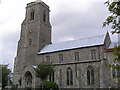
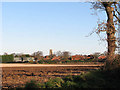
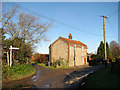
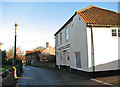
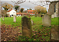
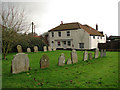
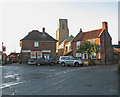
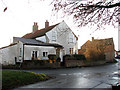
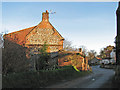
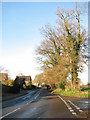
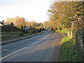
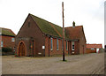
Photos of NR28 0PL
Area Information
Living in NR28 0PL offers a quiet residential experience within a compact cluster measuring 1.6 hectares. The community is well-established, with 2,379 people calling this small postcode their home. Despite its limited size, the population density reaches 80 people per square kilometre, ensuring a tight-knit environment. This specific postcode area functions as a focused residential hub rather than a sprawling suburb, which often appeals to those seeking seclusion without complete isolation. The setting avoids significant planning constraints, with no protected woodlands, nature reserves, or Areas of Outstanding Natural Beauty restricting development. Consequently, residents enjoy a stable environment free from complex heritage or conservation limitations. Daily life here is defined by stability and ease, as the area passes assessments for flood risk, Ramsar wetland sites, and other environmental safety metrics. You can expect a straightforward living situation where property values are likely to reflect the low-maintenance nature of the neighbourhood. The absence of major flood risks or planning constraints provides a solid foundation for long-term ownership plans in this specific sector of King's Lynn Borough.
- Area Type
- Postcode
- Area Size
- 1.6 hectares
- Population
- 2379
- Population Density
- 80 people/km²
The property market in NR28 0PL reflects a distinctly owner-occupied character with minimal rental competition. With 75% of homes held by their owners, the area functions primarily as a buy-to-settle landscape rather than an investment rental zone. Accommodation types almost exclusively consist of Houses, which aligns with the area's low density and 1.6-hectare footprint. For buyers looking at homes in NR28 0PL, this high ownership rate indicates that successful residents view the location as a long-term commitment. The 2379-person population is distributed across this small cluster, suggesting competition for properties will be steady but not overwhelming due to the sheer size of the postcode. You will find a consistent stock of traditional housing suitable for families and small households rather than shared flats or student accommodation. The lack of flats in the data implies that the residential experience revolves around garden space and street-level peace. Potential purchasers should note that moving in will likely mean joining a cohort of peers who have already put down deep roots in this neighbourhood. The housing stock is uniform in purpose, catering to those seeking stability over flexibility.
House Prices in NR28 0PL
Showing 25 properties
| Address | Type | Beds | Baths | Last Sale Price | Last Sale Date | |
|---|---|---|---|---|---|---|
| 23 North Walsham Road, Trunch, NR28 0PL | Semi-detached | 3 | 1 | £275,000 | Aug 2024 | |
| 17 North Walsham Road, Trunch, NR28 0PL | Semi-detached | 3 | 1 | £270,000 | Aug 2023 | |
| 27 North Walsham Road, Trunch, NR28 0PL | house | - | - | £245,000 | Mar 2022 | |
| The Bungalow, North Walsham Road, Trunch, NR28 0PL | Bungalow | 3 | 1 | £325,000 | Mar 2022 | |
| Apple Tree Lodge, North Walsham Road, Trunch, NR28 0PL | Bungalow | 3 | 1 | £327,500 | Nov 2020 | |
| The Poppies, North Walsham Road, Trunch, NR28 0PL | Bungalow | 2 | 1 | £235,000 | May 2020 | |
| 15 North Walsham Road, Trunch, NR28 0PL | house | 3 | - | £182,000 | Jan 2020 | |
| Chalton House, North Walsham Road, Trunch, NR28 0PL | Detached | 4 | 2 | £284,000 | Oct 2015 | |
| The Orchard, North Walsham Road, Trunch, NR28 0PL | Bungalow | 3 | - | £210,000 | Jul 2015 | |
| 25 North Walsham Road, Trunch, NR28 0PL | Semi-detached | 3 | - | £164,000 | Apr 2014 |
Energy Efficiency in NR28 0PL
Daily life in NR28 0PL benefits from access to key amenities located within practical reach of the residential cluster. Residents have five major retail options nearby, including notable venues such as Tesco Mundesley, Waitrose North, and Sainsburys North. These supermarkets ensure you can purchase everyday groceries and household essentials without travelling far beyond the local vicinity. Transport connectivity is strengthened by four nearby railway stations, specifically Gunton, North Walsham, and Roughton Road stations. These rail links provide a direct connection to wider Norfolk and potential employment hubs without requiring a car for every journey. The combination of extensive retail and robust rail access creates a convenience level that rivals larger towns while maintaining a smaller-town feel. You can fill your weekly shopping list at Waitrose or tackle a budget trip at Tesco Mundesley. When you need to travel for work or leisure, the four railway stations offer multiple departure points for regional trains. The lifestyle here balances the quiet of a 1.6-hectare area with the practical reach of extensive local services.
Amenities
Schools
Families with children have reliable options for education when living in NR28 0PL. Antingham and Southrepps Community Primary School serves as a primary provider within the catchment area, offering a standard local education experience. Nearby, Antingham and Southrepps Primary School stands out with a Good Ofsted rating, providing a verified standard of academic care for younger students. This combination of schools means parents have immediate access to primary education without needing to commute further afield for entry-level schooling. The presence of two primary institutions suggests a robust local infrastructure for children aged 4 to 11. Since the accommodation type data confirms that Houses dominate the area, many families likely benefit from proximity to these specific school locations. You do not need to look beyond these named institutions for core educational needs in this postcode. The mix provides continuity for young learners as they transition from reception years through to upper primary classes. These schools represent the cornerstone of family life in this residential cluster.
| Rank | School | Type | Entry gender | Ages |
|---|
Explore more schools in this area
Go to Schools tabDemographics
The people calling NR28 0PL their home form a mature community, with a median age of 47 years. Most residents fall into the adult bracket between 30 and 64 years, indicating a settlement dominated by those in their peak working years and well beyond. This age profile supports a stable population with diverse life stages, from established professionals to semi-retired adults. Home ownership is exceptionally high at 75%, meaning three-quarters of the 2,379 residents live in their own properties. This substantial rate suggests that people come here to settle permanently rather than rent for their entire tenure. The accommodation type data confirms that Houses are the primary housing form, reflecting a preference for detached or semi-detached living over flats. The predominant ethnic group is White, mirroring the broader national and regional demographic trends found across Norfolk. You are likely to interact with long-term neighbours in this area, where gardens and driveways are common features of the streetscape. The community feels homogeneous and settled, with few transient populations moving through the postcode annually.
Household Size
Accommodation Type
Tenure
Ethnic Group
Religion
Household Composition
Age
Household Deprivation
NS-SEC
Explore more demographic insights in this area
Go to Demographics tabPlanning
Planning Constraints
- Flood RiskPremium
- Ramsar Wetland SitesPremium
- Area of Outstanding Natural BeautyPremium
- Protected Nature ReservePremium
- Protected WoodlandPremium