Area Overview for NR24 2HH
Photos of NR24 2HH
Area Information
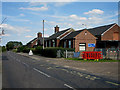
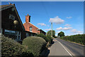
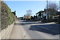
Living in NR24 2HH means settling into a defined residential cluster covering 1.9 hectares in England. This specific postcode serves a population of 2,547 people, creating a settlement with a density of 213 people per square kilometre. The area functions as a small, self-contained cluster rather than a sprawling suburb, which fosters a close-knit community atmosphere. Residents here experience a neighbourhood defined by its compact size and established character, distinct from the wider regions surrounding it. Daily life revolves around this concentrated community core where services are situated within practical walking or short driving distance. You can appreciate a setting that balances residential privacy with immediate access to local necessities without the sprawl typical of larger urban zones. The environment is structured and manageable, offering a clear sense of place for anyone seeking a home in this particular postcode sector. Understanding these physical boundaries is essential for gauging commute times and the convenience of local life in NR24 2HH.
- Area Type
- Postcode
- Area Size
- 1.9 hectares
- Population
- 2547
- Population Density
- 213 people/km²
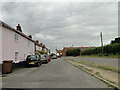
The housing stock in NR24 2HH is characterised entirely by houses, distinguishing it from areas featuring shared ownership flats or multi-unit developments. With 70% of residents being homeowners, the market here is predominantly driven by owner-occupiers rather than private landlords or buy-to-let investors. This dynamic creates a stable property environment where buyers often purchase to stay, not to flip or rent out. Consequently, the property market in NR24 2HH likely values durability, proximity to schools, and garden space typical of single-family homes. The lack of rental listings implies that securing a home requires traditional purchasing routes such as saving for a deposit or remortgaging. Potential buyers looking at these homes should expect competition from local residents who wish to remain in their communities. The market is niche but robust, catering specifically to families and couples who seek the security of property ownership in a dedicated house-centric estate.
House Prices in NR24 2HH
No properties found in this postcode.
Energy Efficiency in NR24 2HH
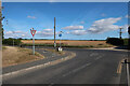
Residents of NR24 2HH enjoy a functional retail and transport network situated within practical reach. You have access to five key retail locations, including the East of England Co-operative Co and Budgens Holt, ensuring daily grocery and shopping needs are met easily. These specific venues provide the convenience of essential errands without the need to travel to larger towns. For wider mobility, Holt operates as a major metro hub, serving as the nearest railway station. This connection links you to broader regional networks, allowing you to commute or travel further afield with relative ease. The combination of local co-operative stores and a dedicated metro station means your lifestyle balances neighbourhood self-sufficiency with access to wider opportunities. You do not need to drive far for essential services, yet you retain flexibility to use public transport for weekend trips or work commutes outside the immediate 1.9 hectare area.
Amenities
Schools
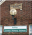
Families in NR24 2HH are primarily supported by Astley Primary School, which is located within practical reach of the residential cluster. This institution is designated as a primary school and holds an Ofsted rating of good. The presence of a single named primary school in the immediate vicinity means that younger children will attend Astley Primary School without needing to travel far. Because the data lists only primary education options, prospective homebuyers must verify secondary school catchment areas externally, as no secondary institutions are currently recorded for this specific postcode. The 'good' rating at Astley Primary School provides a solid educational foundation for younger learners and is a key factor for families evaluating this neighbourhood. While the school mix appears limited to one primary provider in the immediate locality, the quality assurance through the Ofsted grade ensures a standard of education that meets expectations for local residents seeking suitable schooling for their children.
| Rank | School | Type | Entry gender | Ages |
|---|
Explore more schools in this area
Go to Schools tabDemographics
The community within NR24 2HH reflects a mature population profile with a median age of 47 years. Adults between the ages of 30 and 64 form the most common age range, indicating a neighbourhood anchored by working-age families and established households. Stable living arrangements are the norm, with 70% of residents owning their homes outright or with a mortgage. This high rate of home ownership suggests a community with deep roots and long-term commitment to the local area. Almost exclusively, the accommodation type consists of houses, meaning you will not find flats or high-rise apartments in this specific cluster. The predominant ethnic group is White, contributing to a culturally homogeneous social fabric. These demographic factors combine to create a quiet, family-oriented environment where neighbours know each other well. The stability of the population, evidenced by the high ownership rate, means less turnover and a consistent community vibe for those considering settling here.
Household Size
Accommodation Type
Tenure
Ethnic Group
Religion
Household Composition
Age
Household Deprivation
NS-SEC
Explore more demographic insights in this area
Go to Demographics tabPlanning
Planning Constraints
- Flood RiskPremium
- Ramsar Wetland SitesPremium
- Area of Outstanding Natural BeautyPremium
- Protected Nature ReservePremium
- Protected WoodlandPremium