Area Overview for NR13 6UA
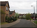
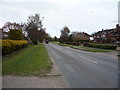
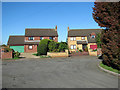
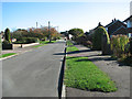
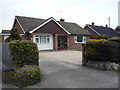
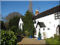
Photos of NR13 6UA


Area Information
Living in NR13 6UA defines a quiet residential existence within the NR13 postcode area of England. This specific postcode covers a compact cluster housing 2,259 individuals, creating a close-knit environment where daily life revolves around the immediate neighbourhood. With a population density of 1,214 people per square kilometre, the area balances residential comfort with sufficient community proximity. The setting is situated within the broader context of the Norfolk coastline, offering a stable foundation for families and established residents who value a settled pace of life. Daily routines focus on local access rather than navigating expansive urban sprawl. The area functions as a self-contained residential zone where streets are primarily designed for living rather than heavy through-traffic. Prospective buyers seeking a home in NR13 6UA should expect a humbler, grounded atmosphere compared to the bustling corridors of Norwich city centre. The physical layout supports a lifestyle where local amenities act as the primary hub for weekly trips. This density ensures that residents maintain visual connection with their neighbours while preserving a degree of privacy within their individual gardens or properties. The area represents a typical example of established suburban living where the community identity is rooted in shared local spaces and mutual familiarity.
- Area Type
- Postcode
- Area Size
- Not available
- Population
- 2259
- Population Density
- 1214 people/km²
The property market in NR13 6UA is characterised by an overwhelmingly owner-occupied environment. With a home ownership rate of 77%, the area functions primarily as a market for those looking to buy and settle rather than those entering traditional rental schemes. This high ownership figure implies that the majority of the 2,259 residents are likely to have purchased their homes within the last two decades or hold properties inherited from previous generations, resulting in a lower turnover of tenancies. The predominant accommodation type is houses, meaning you will find detached, semi-detached, or terraced dwellings rather than high-rise apartment blocks. For buyers seeking homes in NR13 6UA, the expectation should be a stock focused on standalone properties with private outdoor space. This housing profile appeals specifically to families and individuals requiring distinct boundaries and garden access. The small scale of the postcode area means that any available properties on the market will be part of a limited, well-known stock. Investors looking for large-scale lettings may find fewer opportunities here compared to areas with higher private rental demands. Instead, the market serves those wishing to maintain or extend their long-term residence. The 77% ownership statistic suggests a community where residents have significant skin in the game regarding local improvements and property values. Consequently, the property landscape is defined by stability and a focus on residential quality over commercial speculation.
House Prices in NR13 6UA
Showing 30 properties
| Address | Type | Beds | Baths | Last Sale Price | Last Sale Date | |
|---|---|---|---|---|---|---|
| 5 Bainbridge Close, Sprowston, NR13 6UA | house | - | - | - | - | |
| 9 Bainbridge Close, Sprowston, NR13 6UA | house | - | - | - | - | |
| 10 Bainbridge Close, Sprowston, NR13 6UA | house | - | - | - | - | |
| 13 Bainbridge Close, Sprowston, NR13 6UA | house | - | - | - | - | |
| 29 Bainbridge Close, Sprowston, NR13 6UA | house | - | - | - | - | |
| 30 Bainbridge Close, Sprowston, NR13 6UA | house | - | - | - | - | |
| 6 Bainbridge Close, Sprowston, NR13 6UA | house | - | - | - | - | |
| 8 Bainbridge Close, Sprowston, NR13 6UA | house | - | - | - | - | |
| 18 Bainbridge Close, Sprowston, NR13 6UA | house | - | - | - | - | |
| 25 Bainbridge Close, Sprowston, NR13 6UA | house | - | - | - | - |
Energy Efficiency in NR13 6UA
Daily life in NR13 6UA benefits from convenient access to a range of retail and leisure facilities. Residents can patronise five notable retail locations, including the East of England Co-operative Co, Tesco Norwich, and the Lidl Sprowston. These supermarkets provide comprehensive shopping needs without requiring long journeys into distant commercial districts. For rail-based excursions, five stations serve the vicinity, with Salhouse Railway Station acting as a key local gateway. Further afield, Norwich Railway Station and Brundall Gardens Railway Station expand travel options significantly. Leisure and transport travelers also benefit from proximity to Norwich International Airport, located just one airport call away. Those wishing to explore further connections have access to the Wroxham Metro, which serves as a metropolitan link. This concentration of amenities ensures that routine errands and occasional outings are managed efficiently within a short time frame. The availability of these specific venues means you do not need to rely solely on online shopping or major city centres for necessities. Dining and daily purchases are handled locally through the Co-operative and the Lidl, while larger supermarkets are reachable nearby. This practical arrangement supports a lifestyle where convenience is a priority. Living in NR13 6UA allows you to maintain a self-sufficient daily routine while retaining the flexibility to travel to larger hubs when required. The mix of local high streets and transport hubs creates a balanced environment for work, shopping, and leisure.
Amenities
Schools
| Rank | School | Type | Entry gender | Ages |
|---|
Explore more schools in this area
Go to Schools tabDemographics
The community in NR13 6UA reflects a mature and established demographic profile. Adults aged between 30 and 64 years form the most common age range, indicating that the area attracts families and professionals in their prime working years. This age distribution contributes to a stable society where household routines are typically well-established. Significantly, 77% of residents own their homes, suggesting a long-term commitment to the locality and a community built on stability rather than transience. The predominant accommodation type consists of houses, which aligns with the preference for separate living spaces among the resident population. This high level of home ownership often correlates with invested neighbourhood care and a sense of belonging. While specific ethnic breakdowns beyond the predominant group are not detailed, the area maintains a clear demographic identity. The median age of 47 underscores the presence of older households, likely comprising empty nesters or retirees enjoying the relative quiet of life outside the city centre. This age mix fosters a multigenerational environment where elderly residents and younger families coexist in the same streets. The housing stock is not subdivided into large blocks of flats but rather comprises distinct residential units. Living in NR13 6UA offers a demographic landscape where stability is the norm, and residents are likely to have been part of the community for many years.
Household Size
Accommodation Type
Tenure
Ethnic Group
Religion
Household Composition
Age
Household Deprivation
NS-SEC
Explore more demographic insights in this area
Go to Demographics tabPlanning
Planning Constraints
- Flood RiskPremium
- Ramsar Wetland SitesPremium
- Area of Outstanding Natural BeautyPremium
- Protected Nature ReservePremium
- Protected WoodlandPremium