Area Overview for NR13 4RE
Photos of NR13 4RE


Area Information
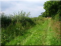
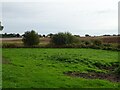
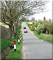
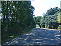
Living in NR13 4RE offers a straightforward residential experience within a specific postcode cluster. This area records a population of 2,020, creating a setting that feels intimate yet functional. With a density of 162 people per square kilometre, the environment balances quiet domesticity with accessible infrastructure. Prospective homebuyers will find this location defined by its residential focus rather than commercial chaos. The layout supports a settled community where daily routines do not require extensive travel. You will find yourself in a zone designed for living, with housing clusters that encourage neighbourly interaction without imposing noise or congestion. The area sits within England, benefiting from the stability and infrastructure networks found throughout the country. There is no ambiguity about what you are purchasing; this is a defined residential environment with clear boundaries and consistent character. Residents here enjoy a sense of place without the overwhelming pace of larger metropolitan centres. The low population density ensures that green spaces and quiet streets remain accessible parts of your daily life.
- Area Type
- Postcode
- Area Size
- Not available
- Population
- 2020
- Population Density
- 162 people/km²
The property market in NR13 4RE is characterised by a strong preference for ownership and housing structures. Almost two-thirds of the population, specifically 66%, are homeowners. This statistic indicates that the local market is driven by buyers seeking to establish a permanent foothold rather than investors looking for short-term yields. Almost all accommodation available in this postcode area comprises houses. There are no mentions of apartment blocks or high-density flats within the provided residential data. This housing stock appeals to individuals or families who value private garden space, driveways, and traditional communal areas. The high ownership rate often correlates with slower price volatility compared to purely rental-led markets. If you are considering purchasing homes in NR13 4RE, you are entering a market defined by stability. The lack of rental-specific properties suggests a scarcity of short-term letting options, which may increase competition among serious buyers interested in this specific cluster. You should expect to engage with estate agents representing long-term owners rather than landlords looking for convenient disposals.
House Prices in NR13 4RE
No properties found in this postcode.
Energy Efficiency in NR13 4RE
Daily life in NR13 4RE benefits from a cluster of practical amenities within easy reach. Retail options are conveniently located close to your home, with five local shops identified in the immediate vicinity. Notable venues include a Spar and two Co-op branches, specifically located at Co-op 49-53 and Co-op 122. These stores provide essential goods, allowing you to run errands without venturing far from home. Transport links are equally accessible, with five rail stations identified near the postcode. Lingwood Railway Station, Brundall Railway Station, and Brundall Gardens Railway Station offer direct links to the wider transport network. You can access train services without requiring a car for most journeys. This proximity to rail hubs makes commuting to other parts of Norfolk or beyond a straightforward logistical task. The presence of these specific venues ensures that your weekly shopping and travel requirements are met efficiently. The area avoids the need to travel to larger towns for basic necessities.
Amenities
Schools
| Rank | School | Type | Entry gender | Ages |
|---|
Explore more schools in this area
Go to Schools tabDemographics
The community in NR13 4RE reflects a settled demographic profile dominated by adults aged between thirty and sixty-four years. The median age stands at forty-seven, indicating a neighbourhood where stasis and family life are common themes. Home ownership is the primary tenure model, with 66% of residents owning their homes outright or with a mortgage. This high rate suggests long-term commitment to the area and stability within local households. The predominant accommodation type consists of houses, treating detached or semi-detached structures as the standard living arrangement. This contrasts sharply with high-rises or purpose-built flats found in other urban zones. The ethnic composition is predominantly White, mirroring the broader patterns seen in many established residential sectors of England. You will encounter a community where age groups overlap, likely meaning schools cater to families while leisure facilities serve working professionals and retirees. The data paints a picture of a mature neighbourhood avoiding the transient nature of student housing or temporary rental sectors.
Household Size
Accommodation Type
Tenure
Ethnic Group
Religion
Household Composition
Age
Household Deprivation
NS-SEC
Explore more demographic insights in this area
Go to Demographics tabPlanning
Planning Constraints
- Flood RiskPremium
- Ramsar Wetland SitesPremium
- Area of Outstanding Natural BeautyPremium
- Protected Nature ReservePremium
- Protected WoodlandPremium