Area Overview for NR12 8PT
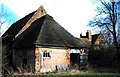
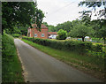
Photos of NR12 8PT


Area Information
NR12 8PT represents a specific, small residential cluster covering just 1.3 square kilometres in Norfolk. This compact footprint serves 1,475 people, creating a population density of 43 individuals per square kilometre. The area feels intimate because its limited size concentrates residents within a close-knit perimeter. Daily life here revolves around Local Council jurisdictions rather than the sprawl found in larger towns. You experience a neighbourhood where distances are short and interactions with neighbours are frequent. The geography dictates that most long journeys require leaving the boundaries of the postcode immediately. Research confirms this location sits on the edge of natural landscapes, specifically near the Wroxham rail stations and rivers. This geographical setting influences the character of the homes and the pace of life. You will find that services and shops are accessible within a short drive, but you must plan your travel to reach major retail parks or city centres. The area offers a quiet existence away from the congestion of Norfolk's busiest transport hubs. Living in NR12 8PT means accepting a rural rhythm while maintaining access to essential train connections for commuting to London or Norwich. The small size ensures that you know your immediate surroundings, but you also recognise that the area relies on nearby towns for larger amenities. This postcode covers a distinct community that balances isolation with connectivity through careful planning of trips outside the immediate vicinity.
- Area Type
- Postcode
- Area Size
- 1.3 km²
- Population
- 1475
- Population Density
- 43 people/km²
The property market in NR12 8PT is defined by a strong preference for owning a home. With 75 per cent household ownership, the area functions primarily as an owner-occupied zone rather than a rental estate. Your search for homes in NR12 8PT will overwhelmingly lead you to detached, semi-detached, or terraced houses. This contrasts sharply with urban postal codes where flats and apartments dominate the inventory. The concentration of houses results from the rural nature of the postcode and the surrounding agricultural land values. Buyers seeking this specific asset class find limited competition for the few properties available on the open market. Rental yields may be lower for investors because the demand for private rentals is subdued by the high ownership rate. When you view a property, you are likely looking at a standalone dwelling built for extended family living rather than a multi-unit building. The housing stock includes a mix of eras, though renovation potential often outweighs move-in readiness for purchasers. Cemeteries and older village greens often surround these houses, adding to the historic appeal without increasing density. The market lacks the transient nature of student towns or tourist-dependent areas. Stability in the housing market here means that prices often correlate with local wage growth and train line reliability rather than London property bubbles. You own a physical asset that serves as a permanent base rather than a short-term investment vehicle. The scarcity of flats means that anyone requiring a bungalow or a modern apartment must look elsewhere entirely.
House Prices in NR12 8PT
Showing 14 properties
| Address | Type | Beds | Baths | Last Sale Price | Last Sale Date | |
|---|---|---|---|---|---|---|
| Sula House, Ferry View Estate, Horning, NR12 8PT | Detached | - | - | £2,738,000 | Aug 2020 | |
| Journeys End, Ferry View Estate, Horning, NR12 8PT | Bungalow | 2 | - | £380,000 | May 2015 | |
| Horning House, Ferry View Estate, Horning, NR12 8PT | office_workshop | 2 | 1 | £585,000 | Nov 2011 | |
| The Moorings, Ferry View Estate, Horning, NR12 8PT | Bungalow | 2 | 1 | - | - | |
| Quiet Waters, Ferry View Estate, Horning, NR12 8PT | Detached | 4 | 3 | - | - | |
| Waters Edge, Ferry View Estate, Horning, NR12 8PT | Bungalow | 1 | - | - | - | |
| Ferry View, Ferry View Estate, Horning, NR12 8PT | Detached | 4 | 2 | - | - | |
| Wilds Boatyard, Ferry View Estate, Horning, NR12 8PT | Leisure | - | - | - | - | |
| Oakdale, Ferry View Estate, Horning, NR12 8PT | Bungalow | - | - | - | - | |
| Bureview, Ferry View Estate, Horning, NR12 8PT | Detached | - | - | - | - |
Energy Efficiency in NR12 8PT
Lifestyle and daily convenience revolve around a small selection of nearby services and amenities. Residents have access to five retail outlets in the immediate vicinity, including the East of England Co-operative Co, Co-op 49-53, and Co-op 122. These shops form the backbone of local shopping, allowing you to purchase groceries and household essentials without travelling far. The network of five railway stations, including Hoveton & Wroxham, Salhouse, and Lingwood, offers regular departures to different towns. You can access Wroxham as a metro-style hub for broader retail and leisure activities within a short drive. For entertainment and dining, your options depend heavily on visiting Wroxham or other nearby villages. The area lacks large shopping malls or cinema complexes, meaning leisure time often involves day trips rather than local exploration. Parks and green spaces exist due to the planning constraints of the area, such as the presence of Ramsar wetland sites and protected nature reserves. These natural features provide a free outdoor environment where walking and nature observation take precedence over playground activities. The proximity to a protected nature reserve means that the land around you holds ecological significance for the wider region. This connection to the environment shapes the lifestyle towards quieter activities like cycling, fishing, or wildlife watching.
Amenities
Schools
Families considering this area have one primary educational option listed in close proximity. Fairhaven Church of England Voluntary Aided Primary School operates within the catchment area for NR12 8PT. The school holds a 'good' Ofsted rating, confirming that it meets the standards set by the education department for teaching quality and child welfare. This rating indicates that the school provides a satisfactory education environment for young children. As a voluntary aided institution, the school maintains some religious character elements while operating under government funding. There are no secondary schools listed in the immediate data provided for this specific postcode cluster. This means that pupils attending primary school here will typically transfer to secondary institutions in larger nearby towns like Great Yarmouth or Wroxham. Parents must budget for transport costs during those years if they do not live zoned for those larger institutions. The presence of a single primary school with a 'good' rating suggests a quiet, understated educational culture rather than a high-pressure academic hub. You may need to travel further for older children seeking A-levels or specific vocational courses. This educational setup suits families who prioritise a calm childhood environment over proximity to major school campuses. The school's voluntary aided status often allows for a controlled admissions policy that prioritises local children before expanding to recruitment outside the borough.
| Rank | School | Type | Entry gender | Ages |
|---|
Explore more schools in this area
Go to Schools tabDemographics
The community in NR12 8PT reflects a mature and stable population. The median age stands at 47 years, with the largest concentration of residents falling into the 30 to 64 age bracket. This demographic profile indicates a neighbourhood dominated by adults who have already established their careers and families. Home ownership is the defining feature of the area, with 75 per cent of households owning their properties outright or through a mortgage. This high rate of ownership suggests that residents view themselves as long-term inhabitants rather than transient renters. Houses form the predominant type of accommodation, aligning with the preferences of this age group and the cost of land in the region. The ethnic composition is predominantly White, mirroring the traditional character of many Norfolk villages and hamlets. Because the population density is low, you find fewer diverse household structures compared to urban settings. The demographic stability extends to your immediate neighbours, who are likely to have lived in their homes for many years. This consistency creates a predictable social environment where community events and local history hold significant weight. Residents in this age range typically seek stability and convenience over high-energy entertainment districts. The fact that three-quarters of the population owns their homes also influences local council tax revenue and community investment levels. Living here means joining a community where the social fabric relies on established families and long-term planning decisions.
Household Size
Accommodation Type
Tenure
Ethnic Group
Religion
Household Composition
Age
Household Deprivation
NS-SEC
Explore more demographic insights in this area
Go to Demographics tabPlanning
Planning Constraints
- Flood RiskPremium
- Ramsar Wetland SitesPremium
- Area of Outstanding Natural BeautyPremium
- Protected Nature ReservePremium
- Protected WoodlandPremium