Area Overview for NR11 8PP
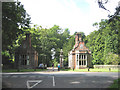
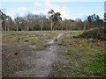
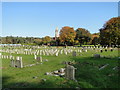
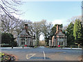
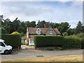
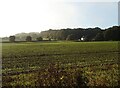
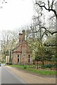
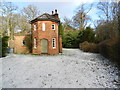
Photos of NR11 8PP

Area Information
Living in NR11 8PP offers a quiet residential experience within a small cluster covering 64.2 hectares. The population stands at 2,356 residents, creating a low-density environment with an average of 85 people per square kilometre. This postcode area represents a specific residential zone that prioritises space over urban density. You will find a community characterised by its size and isolation from larger city centres, making it ideal for those seeking tranquility. Daily life here revolves around proximity to the coast and nearby towns rather than the immediate hustle of a major urban hub. The area functions as a self-contained neighbourhood where residents enjoy open skies and reduced traffic noise. Homebuyers looking for homes in NR11 8PP should expect a setting defined by its moderate population and lack of high-rise development. The demographic profile suggests a mature community where social interactions often centre on neighbourly support rather than anonymity. While not a bustling hotspot, the area provides a stable foundation for family life or retirement. Fact-based observation shows this is a place where you live among people who have settled down, rather than a transient district. The combination of a small footprint and a consistent population size ensures that the environment changes little year over year, offering a predictable quality of life for those who value stability.
- Area Type
- Postcode
- Area Size
- 64.2 hectares
- Population
- 2356
- Population Density
- 85 people/km²
The property market in NR11 8PP is defined by a strong preference for owner-occupied housing. With home ownership reaching 76%, buyers will find a stock dominated by people who have established roots in the locality. This percentage significantly outpaces national averages for rental zones, indicating a market where purchase listings are more common than private rentals. The accommodation type is exclusively houses, which means the area lacks any apartment blocks or flat conversions. You will see detached, semi-detached, and terraced houses comprising the entire housing stock of this specific postcode. For those considering homes in NR11 8PP, the market reflects a demand for space and privacy over the convenience of city living. The lack of flats suggests that joint purchasing or multi-generational living is less common than it would be in a flat-dominated area. Buyers looking at this small area and its immediate surroundings will encounter properties suited to families or retirees who require larger indoor and outdoor living areas. The high home ownership rate implies that many current owners may be motivated to sell, potentially increasing supply for buyers seeking a foothold in the local market. When evaluating property values or potential resale prospects, the fact that nearly three-quarters of residents own their homes is a key indicator of market stability. This environment typically supports steady property values driven by the need for traditional family housing in the East of England.
House Prices in NR11 8PP
Showing 6 properties
| Address | Type | Beds | Baths | Last Sale Price | Last Sale Date | |
|---|---|---|---|---|---|---|
| Wayside Farm, Cromer Road, Felbrigg, NR11 8PP | Detached | 5 | - | £612,500 | Sep 2014 | |
| Cromer Lodge North, Cromer Road, Felbrigg, NR11 8PP | Detached | - | - | - | - | |
| 3, Wayside Farm, Cromer Road, Felbrigg, NR11 8PP | Detached | - | - | - | - | |
| 1, Wayside Farm, Cromer Road, Felbrigg, NR11 8PP | Detached | - | - | - | - | |
| 4, Wayside Farm, Cromer Road, Felbrigg, NR11 8PP | Detached | - | - | - | - | |
| 2, Wayside Farm, Cromer Road, Felbrigg, NR11 8PP | Detached | - | - | - | - |
Energy Efficiency in NR11 8PP
Daily life in NR11 8PP benefits from practical access to essential amenities within a short drive. Retail options are concentrated in Cromer, where you will find Lidl Cromer, Co-op Cromer, and Morrisons Cromer. These three major supermarkets ensure that groceries, household goods, and daily necessities are easily accessible. You do not need to travel far to stock your pantry, as these stores provide a complete shopping experience for a residential cluster of this size. For transportation, rail links are available at Roughton Road Railway Station, Cromer Railway Station, and West Runton Railway Station. These three stations offer regular services, giving you the ability to commute to nearby towns or take leisure trips along the coast. A metro option exists at Weybourne, providing additional transport flexibility for longer journeys. While not a full metropolitan network, this connection integrates the residential area into the wider transport grid. The combination of supermarkets and train stations means you can manage your weekly shop and your weekend plans from within a manageable distance. This mix of retail and transit supports a manageable routine without the isolation common in rural postcodes. Residents enjoy the convenience of having major brands like Lidl and Morrisons nearby while retaining the peace of a low-density home. The presence of three train stations specifically serves the local rail network, ensuring that connectivity is not reliant solely on road vehicles. This lifestyle suits those who value the ability to visit without needing a car permanently, although a vehicle is still useful for accessing the specific shops in Cromer.
Amenities
Schools
Families living in NR11 8PP have access to two primary schools within the local vicinity. St. Mary's (Endowed) CofE VA Primary School serves as one option for younger children in the community. St Mary's Church of England Primary Academy stands as the second nearby educational facility offering primary education. Both institutions are designated as primary schools, meaning there are no secondary or high schools listed in the immediate data for this specific postcode cluster. This situation suggests that older children in the area may need to travel further for secondary education, or that the local catchment area feeds into larger schools outside the immediate NR11 8PP bounds. For parents considering living in this area, the proximity of these two primary academies is a significant asset. The presence of Church of England schools indicates a community with a historical link to religious education and tradition. You can expect bilingual education options or faith-based curricula, as is standard for CofE institutions. While the data only lists primary options, the existence of these specific academies confirms a functional network for young families. If you are looking at schools near NR11 8PP, these two establishments are the primary choices available directly adjacent to the residential cluster. Prospective homebuyers should check the specific catchment zones for both St. Mary's (Endowed) CofE VA Primary School and St Mary's Church of England Primary Academy to ensure eligibility. Near this postcode, educational provision is focused on early childhood and primary development, supporting families with children typically aged between four and eleven years old.
| Rank | School | Type | Entry gender | Ages |
|---|
Explore more schools in this area
Go to Schools tabDemographics
The community in NR11 8PP reflects the needs of adults, with the median age standing at 47 years. Most residents fall into the 30 to 64 year range, indicating a population composed primarily of households rather than students or retirees in their seventies. This age profile suggests a neighbourhood where families with older children or empty-nesters dominate the local scene. Home ownership is the standard here, with 76% of residents owning their property outright or with a mortgage. This high rate of ownership creates a vested interest in the local community and long-term neighbourhood improvement. Accommodation types are exclusively houses, meaning you will find detached, semi-detached, or terraced properties rather than flats or apartments. The predominance of houses aligns with the preference for gardens and private space found in this demographic. The predominant ethnic group within the area is White, contributing to a culturally homogeneous community where shared traditions often bind neighbours together. There is no data suggesting significant diversity in housing types, which reinforces the suburb's identity as a traditional residential zone. This demographic makeup means local schools and shops cater specifically to families and established households rather than young professionals or urban dwellers. The stability of the age and ownership figures points to a settled environment where residents are likely to stay for many years.
Household Size
Accommodation Type
Tenure
Ethnic Group
Religion
Household Composition
Age
Household Deprivation
NS-SEC
Explore more demographic insights in this area
Go to Demographics tabPlanning
Planning Constraints
- Flood RiskPremium
- Ramsar Wetland SitesPremium
- Area of Outstanding Natural BeautyPremium
- Protected Nature ReservePremium
- Protected WoodlandPremium