Area Overview for Mildenhall Kingsway & Market Ward
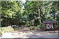
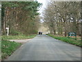
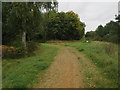
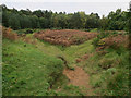
Photos of Mildenhall Kingsway & Market Ward
Area Information
Living in Mildenhall Kingsway & Market Ward means residing in a compact district characterised by a tightly knit community and established infrastructure. The area covers a total size of 7.5 km², providing a defined neighbourhood feel within the borough unitary structure of Kings Lynn and West Norfolk. You are choosing a location where daily life revolves around local familiarity rather than rapid urban expansion. The median age of 70 suggests a demographic heavily weighted towards older residents or retirees who value stability and quieter surroundings. This statistical reality shapes the rhythm of the town, creating an environment where pace is less frantic and community bonds are often deep-rooted. When planning your move to this ward, you are entering an area where the built environment has supported this specific age profile for some time. The fixed nature of the area size ensures that services and amenities are concentrated enough to remain accessible without the sprawl found in larger urban centres.
- Area Type
- District Borough Unitary Ward
- Area Size
- 7.5 km²
- Population
- Not available
- Population Density
- Not available
Demographics
The community profile of Mildenhall Kingsway & Market Ward is dominated by a senior demographic, with a median age of 70. You will find that the population is significantly older than the national average, a fact reflected in the fact that the most common age range is listed as Age: Total in the available breakdowns. This concentration of older residents influences local spending habits, service demand, and the overall social atmosphere. Home ownership stands at 51%, indicating a balanced split between borrowers and owners rather than a district defined by high-density renting or social housing alone. While specific data on ethnicity and religion is not detailed in the provided figures, the home ownership level suggests a stable tenure structure common in semi-rural or suburban wards. Accommodation types reflect the needs of this older population, likely comprising spacious bungalows or detached homes suitable for later life. Understanding these numbers helps you anticipate a community where neighbourly interactions, running local clubs, and supporting local shops remain central to daily life.
Household Size
Accommodation Type
Tenure
Ethnic Group
Religion
Household Composition
Age
Household Deprivation
NS-SEC
Explore more demographic insights in this area
Go to Demographics tabPlanning
Planning Constraints
- Flood RiskPremium
- Ramsar Wetland SitesPremium
- Area of Outstanding Natural BeautyPremium
- Protected Nature ReservePremium
- Protected WoodlandPremium
- Crime RiskPremium