Area Overview for LU6 1SJ
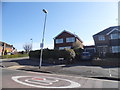
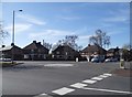
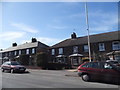
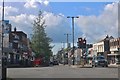
Photos of LU6 1SJ


Area Information
LU6 1SJ is a compact residential postcode in England, covering 4,252 square metres and home to 1,668 residents. Its high population density of 392,245 people per square kilometre reflects a tightly knit community. The area is characterised by a mix of established housing and proximity to key infrastructure. With a median age of 47, the population skews towards adults aged 30–64, suggesting a stable, family-oriented demographic. Daily life here is shaped by its small size and the availability of nearby amenities. Residents benefit from a range of retail options and multiple rail stations within reach, making it convenient for commuters. The area’s compact nature means it is likely to be surrounded by similar small clusters, creating a cohesive local environment. While the data does not specify historical context, the presence of schools and transport links indicates a functional, practical lifestyle for those living in LU6 1SJ.
- Area Type
- Postcode
- Area Size
- 4252 m²
- Population
- 1668
- Population Density
- 3788 people/km²
LU6 1SJ is primarily an owner-occupied area, with 62% of homes owned by residents rather than rented. The accommodation type is predominantly houses, which is typical of smaller, residential postcode areas. This suggests a market where properties are likely to be family homes rather than investment properties or rental units. The compact size of the area means the housing stock is limited, which could affect availability for buyers. Those seeking homes here may find a focus on established, single-family residences. The proximity to schools and transport links adds to the area’s appeal for buyers prioritising convenience. However, the small size of LU6 1SJ means that the immediate surroundings are critical for assessing housing options, as the postcode itself does not encompass a large geographical footprint.
House Prices in LU6 1SJ
No properties found in this postcode.
Energy Efficiency in LU6 1SJ
The lifestyle in LU6 1SJ is supported by a range of amenities within practical reach. Retail options are abundant, with five notable stores including Iceland Dunstable, Aldi Beecroft, and Asda Dunstable. These provide convenience for daily shopping and household needs. The area’s rail connectivity, with stations such as Leagrave and Luton, offers easy access to commuting and regional travel. While the data does not specify parks or leisure facilities, the presence of multiple retail and transport options suggests a practical, community-focused lifestyle. The compact nature of the postcode means amenities are likely concentrated, making it efficient for residents to access services without long journeys. The combination of retail, rail, and proximity to schools creates a balanced environment for daily living.
Amenities
Schools
The nearest schools to LU6 1SJ include Dunstable Icknield Lower School, which operates as both a primary school and an academy. While the data does not provide Ofsted ratings, the presence of two entries for the same institution suggests it may serve multiple age groups or have distinct phases. Families in the area benefit from a single primary school with academy status, which often indicates a focus on educational standards and autonomy. The absence of secondary schools in the data means residents may need to look further afield for secondary education. The mix of primary and academy types implies a range of educational options, though the limited number of schools highlights the importance of proximity to other educational institutions in the wider region.
| Rank | School | Type | Entry gender | Ages |
|---|
Explore more schools in this area
Go to Schools tabDemographics
The community in LU6 1SJ is predominantly composed of adults aged 30–64, with a median age of 47. This suggests a mature, established population, likely with long-term ties to the area. Home ownership is high at 62%, indicating a stable housing market where most residents own their properties. The accommodation type is primarily houses, which aligns with the higher proportion of owner-occupied homes compared to flats or apartments. The predominant ethnic group is White, though specific diversity metrics are not provided. The age profile and ownership figures imply a community focused on long-term residency rather than transient populations. With no data on deprivation levels, it is reasonable to infer that the area’s services and infrastructure cater to the needs of its older, home-owning residents.
Household Size
Accommodation Type
Tenure
Ethnic Group
Religion
Household Composition
Age
Household Deprivation
NS-SEC
Explore more demographic insights in this area
Go to Demographics tabPlanning
Planning Constraints
- Flood RiskPremium
- Ramsar Wetland SitesPremium
- Area of Outstanding Natural BeautyPremium
- Protected Nature ReservePremium
- Protected WoodlandPremium