Area Overview for LU2 8DP
Photos of LU2 8DP
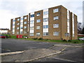
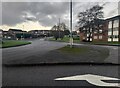
2 photos from this area
Area Information
Key information about the LU2 8DP including its size, population, and administrative classification.
- Area Type
- Postcode
- Area Size
- 1.8 hectares
- Population
- 1400
- Population Density
- 4846 people/km²
House Prices in LU2 8DP
62
Properties
£204,106
Average Sold Price
£60,000
Lowest Price
£322,000
Highest Price
Showing 62 properties
| Address | Type | Beds | Baths | Last Sale Price | Last Sale Date | |
|---|---|---|---|---|---|---|
| 113 Chesford Road, Luton, LU2 8DP | Detached | 3 | 1 | £322,000 | Aug 2025 | |
| 83 Chesford Road, Luton, LU2 8DP | Terraced | 2 | 1 | £256,000 | Jun 2025 | |
| 173 Chesford Road, Luton, LU2 8DP | Terraced | 3 | 1 | £305,000 | Aug 2024 | |
| 177 Chesford Road, Luton, LU2 8DP | Semi-detached | 2 | 1 | £275,000 | Jun 2024 | |
| 149 Chesford Road, Luton, LU2 8DP | Semi-detached | 3 | 1 | £295,000 | Mar 2024 | |
| 187 Chesford Road, Luton, LU2 8DP | Semi-detached | 2 | 1 | £312,000 | Dec 2022 | |
| 91 Chesford Road, Luton, LU2 8DP | Terraced | 2 | 1 | £237,000 | Sep 2020 | |
| 119 Chesford Road, Luton, LU2 8DP | Semi-detached | 2 | - | £260,000 | Aug 2020 | |
| 131 Chesford Road, Luton, LU2 8DP | Semi-detached | 3 | 1 | £245,000 | Mar 2020 | |
| 111 Chesford Road, Luton, LU2 8DP | house | - | - | £255,000 | Feb 2020 |
Page 1 of 7
Energy Efficiency in LU2 8DP
Amenities
Schools
| Rank | School | Type | Entry gender | Ages |
|---|
Explore more schools in this area
Go to Schools tabDemographics
Household Size
Two person
most common
Accommodation Type
Houses
most common
Tenure
85
majority
Ethnic Group
White
most common
Religion
N/A
most common
Household Composition
N/A
most common
Age
47
median
Adults (30-64 years)
most common
Household Deprivation
N/A
with no deprivation
NS-SEC
33
in Lower managerial occupations
Explore more demographic insights in this area
Go to Demographics tabPlanning
Planning Constraints
- Flood RiskPremium
- Ramsar Wetland SitesPremium
- Area of Outstanding Natural BeautyPremium
- Protected Nature ReservePremium
- Protected WoodlandPremium