Area Overview for LU1 1TY
Photos of LU1 1TY
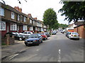


19 photos from this area
Area Information
Key information about the LU1 1TY including its size, population, and administrative classification.
- Area Type
- Postcode
- Area Size
- 5.4 hectares
- Population
- 1807
- Population Density
- 3041 people/km²
House Prices in LU1 1TY
45
Properties
£193,498
Average Sold Price
£53,500
Lowest Price
£373,000
Highest Price
Showing 45 properties
| Address | Type | Beds | Baths | Last Sale Price | Last Sale Date | |
|---|---|---|---|---|---|---|
| 235 Runley Road, Luton, LU1 1TY | Semi-detached | 3 | 2 | £373,000 | Apr 2023 | |
| 229 Runley Road, Luton, LU1 1TY | Retail | 3 | 1 | £353,000 | Nov 2022 | |
| 233 Runley Road, Luton, LU1 1TY | house | - | - | £331,000 | Jul 2022 | |
| 255 Runley Road, Luton, LU1 1TY | Bungalow | - | - | £282,500 | Jun 2021 | |
| 247 Runley Road, Luton, LU1 1TY | Bungalow | - | - | £350,000 | Jun 2021 | |
| 283 Runley Road, Luton, LU1 1TY | Bungalow | - | - | £291,000 | Jan 2021 | |
| 237 Runley Road, Luton, LU1 1TY | Semi-detached | 3 | 1 | £285,000 | Nov 2018 | |
| 249 Runley Road, Luton, LU1 1TY | Bungalow | 4 | 2 | £315,000 | Oct 2018 | |
| 277 Runley Road, Luton, LU1 1TY | Semi-detached | 2 | 1 | £260,000 | Jul 2017 | |
| 253 Runley Road, Luton, LU1 1TY | Bungalow | - | - | £274,000 | Feb 2017 |
Page 1 of 5
Energy Efficiency in LU1 1TY
Amenities
Schools
| Rank | School | Type | Entry gender | Ages |
|---|
Explore more schools in this area
Go to Schools tabDemographics
Household Size
Family (3-5 people)
most common
Accommodation Type
Houses
most common
Tenure
54
majority
Ethnic Group
asian_total
most common
Religion
N/A
most common
Household Composition
N/A
most common
Age
22
median
Adults (30-64 years)
most common
Household Deprivation
N/A
with no deprivation
NS-SEC
15
in Lower managerial occupations
Explore more demographic insights in this area
Go to Demographics tabPlanning
Planning Constraints
- Flood RiskPremium
- Ramsar Wetland SitesPremium
- Area of Outstanding Natural BeautyPremium
- Protected Nature ReservePremium
- Protected WoodlandPremium