Area Overview for LU1 1HF
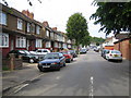
Photos of LU1 1HF


Area Information
LU1 1HF is a small residential postcode area in England, home to around 1,807 people. It is a compact cluster of homes, predominantly houses, serving a community with a median age of 22 but where the most common age group is adults aged 30–64. This suggests a mix of younger residents and families, creating a dynamic yet stable local environment. The area’s proximity to Luton and its transport links make it accessible for commuters, while its modest size means it is likely a tight-knit neighbourhood. With 54% of residents owning their homes, there is a balance between owner-occupied properties and rental stock, though the exact proportion of renters is not specified. The area’s demographics indicate a diverse population, with the Asian community forming the largest ethnic group. Daily life here is shaped by nearby amenities, including shops, rail stations, and proximity to London Luton Airport, which may appeal to those seeking convenience for travel or work. While the area lacks large-scale infrastructure, its small size and specific services cater to local needs.
- Area Type
- Postcode
- Area Size
- Not available
- Population
- 1807
- Population Density
- 3041 people/km²
The property market in LU1 1HF is characterised by a 54% home ownership rate, with houses being the predominant accommodation type. This suggests a focus on owner-occupied properties, though the exact number of rental homes is not specified. The small size of the area means the housing stock is limited, potentially making it a niche market for buyers seeking specific properties. The presence of houses rather than flats or apartments may appeal to families or those prioritising space. However, the lack of detailed data on property types or price ranges means the market’s competitiveness or affordability cannot be assessed. Proximity to rail stations and London Luton Airport could enhance the area’s appeal for commuters or those requiring travel links. For buyers, the limited size of LU1 1HF means the immediate surroundings may hold more options, though this area is likely to be part of a broader local housing landscape.
House Prices in LU1 1HF
No properties found in this postcode.
Energy Efficiency in LU1 1HF
The lifestyle in LU1 1HF is shaped by nearby amenities within practical reach. Retail options include Aldi Bury, Lidl Hatters, and Asda Empire, offering convenience for grocery shopping. The area’s rail stations—Leagrave, Luton, and Luton Airport Parkway—provide easy access to regional and national transport networks, while proximity to London Luton Airport enhances travel flexibility. Though the data does not mention parks or leisure facilities, the presence of shops and transport hubs suggests a functional, service-oriented lifestyle. The small size of the area may mean residents rely on nearby towns for more extensive leisure options. The combination of retail, transport, and travel links creates a practical environment for those prioritising accessibility over large-scale amenities.
Amenities
Schools
Near LU1 1HF are two educational institutions: Foxdell Junior School, a primary school, and Luton Education, Tuition and Guidance Centre, which is categorised as an ‘other’ type of school. The presence of a primary school suggests the area is suitable for families with young children, though the absence of secondary schools nearby may require residents to travel for higher education. The ‘other’ category school may offer specialist services such as tutoring or vocational training, complementing the primary school’s role. However, the data does not include Ofsted ratings or academic performance metrics, so the quality of education cannot be evaluated. The mix of school types indicates a range of educational provisions, but parents may need to look beyond LU1 1HF for comprehensive schooling options.
| Rank | School | Type | Entry gender | Ages |
|---|
Explore more schools in this area
Go to Schools tabDemographics
The population of LU1 1HF is 1,807, with a median age of 22, though the most common age range is adults aged 30–64. This suggests a community that includes both younger residents and a significant proportion of working-age individuals. Home ownership stands at 54%, indicating that nearly half of residents live in properties they own, while the remaining 46% likely rent. The accommodation type is predominantly houses, which may reflect a preference for family homes or larger living spaces. The area’s diversity is marked by the Asian_total group being the largest ethnic category, though specific percentages are not provided. This demographic profile implies a mix of family units and possibly multi-generational households. The data does not include deprivation statistics, but the presence of retail amenities and transport links suggests access to basic services. The age distribution, with a median lower than the most common age range, may indicate a younger population influx, possibly linked to nearby employment opportunities.
Household Size
Accommodation Type
Tenure
Ethnic Group
Religion
Household Composition
Age
Household Deprivation
NS-SEC
Explore more demographic insights in this area
Go to Demographics tabPlanning
Planning Constraints
- Flood RiskPremium
- Ramsar Wetland SitesPremium
- Area of Outstanding Natural BeautyPremium
- Protected Nature ReservePremium
- Protected WoodlandPremium