Area Overview for Little Braxted
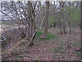
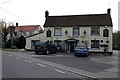
Photos of Little Braxted


Area Information
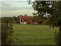
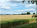
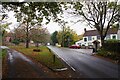
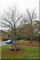
Living in Little Braxted means embracing a compact rural lifestyle defined by its close proximity to Witham yet distinct separation by the River Blackwater. This civil parish in the Maldon district covers a modest 2.5 square kilometres, creating a tightly knit village atmosphere. You will find the community situated about one mile east of the market town, accessible via a narrow winding lane south from the A12 motorway. The land itself varies significantly, rising from approximately 20 metres above sea level to nearly 70 metres in the southeast, supporting both pastoral meadows and arable fields. Historically, the parish held fewer than 100 residents, but the population has grown to approximately 2,086 modern-day inhabitants. You will navigate a setting where the historic St Nicholas Church, built around 1120, dominates the skyline alongside the former Roberts family seat of Little Braxted Hall. Daily life here revolves around quiet streets, a single pub known as The Green Man, and the slow pace that characterises Essex villages. The area offers a tangible connection to its past, from Domesday records noting a mill to Victorian restorations that shaped its current aesthetic.
- Area Type
- Parish
- Area Size
- 2.5 km²
- Population
- Not available
- Population Density
- Not available
Demographics
The community profile of Little Braxted reflects a settled population with a median age of 70 years. This demographic skew indicates a neighbourhood where many residents have lived there for decades rather than a transient population of young career starters. Household composition data shows that total households are dominated by older demographics, suggesting that families with dependent children are less common than empty-nesters or retirees. Despite the rural setting, home ownership is the norm, standing at an impressive 87%. This high rate confirms that the vast majority of households reside in their own property rather than renting. The accommodation type data and predominant ethnic group figures indicate a traditional settlement pattern where long-term ownership is the primary route to local residence. You should expect a stable environment where residents have deep roots in the parish. The demographic makeup does not highlight significant diversity metrics in the provided records, which aligns with many established rural villages in Essex that prioritise local lineage over newcomer integration.
Household Size
Accommodation Type
Tenure
Ethnic Group
Religion
Household Composition
Age
Household Deprivation
NS-SEC
Explore more demographic insights in this area
Go to Demographics tabPlanning
Planning Constraints
- Flood RiskPremium
- Ramsar Wetland SitesPremium
- Area of Outstanding Natural BeautyPremium
- Protected Nature ReservePremium
- Crime RiskPremium