Area Overview for Little Barford
Photos of Little Barford


Area Information
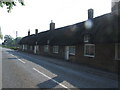
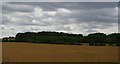
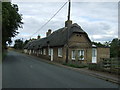
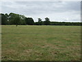
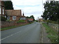
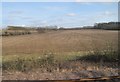
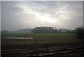
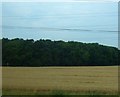
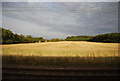
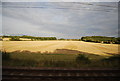
Little Barford is a civil parish in the Borough of Bedford, standing as a hamlet with a small footprint of 5.1 km². You will find this parish roughly 7 miles northeast of Bedford and just 2 miles south of St Neots. The area borders the River Great Ouse to the west and sits between Bedfordshire and Cambridgeshire. Life here reflects its historic roots, first recorded in 1178 as belonging to Ramsey Abbey. The name derives from the Old English "Beorcford," meaning Birch Ford. While the population has declined significantly from 80 in 1801 to far fewer residents by the turn of the new millennium, the landscape remains defined by mostly arable farmland in the Claylands. You will see Grade II listed 18th-century thatched cottages and late 19th-century estate cottages that add character to the village. A church with Norman origins, St Denys Church, stands as a redundant monument cared for by the Churches Conservation Trust. An earthwork of a deserted medieval settlement also marks the land. The area includes an industrial zone in the north containing a power station history, a Marshall Motor Group dealership, and a Biffa waste disposal depot. Living in Little Barford means accepting a quiet rural existence where agricultural land dominates the viewshed, yet you remain close to the transport networks serving Eastern England.
- Area Type
- Parish
- Area Size
- 5.1 km²
- Population
- Not available
- Population Density
- Not available
Demographics
The community in Little Barford is defined by an older population profile. The median age is 70, indicating a significant proportion of elderly residents reside here. Your neighbours will mostly be retirees or those settled long-term, rather than young families or working-age populations moving into new builds. Home ownership stands at 73%, which is a high figure for the area. This statistic confirms that the vast majority of people living in Little Barford own their homes outright or via mortgage, rather than renting. There are very few rental units available compared to the dominated owner-occupied stock. The area encompasses a single civil parish where households are static. You will find that accommodation types vary slightly, but the high ownership rate suggests stability within the parish. The demographic data does not indicate a diverse ethnic mix or young transient workers, aligning with the decline in overall population numbers seen from the 19th century to 2001. When considering homes in Little Barford, expect a quiet environment where the senior residents draw the primary community strength. The age profile means local amusements may favour leisure over nightlife or youth sports. You are not in a scene of rapid demographic change, but rather a settled hamlet where residents have chosen to stay or retire.
Household Size
Accommodation Type
Tenure
Ethnic Group
Religion
Household Composition
Age
Household Deprivation
NS-SEC
Explore more demographic insights in this area
Go to Demographics tabPlanning
Planning Constraints
- Flood RiskPremium
- Ramsar Wetland SitesPremium
- Area of Outstanding Natural BeautyPremium
- Protected Nature ReservePremium
- Crime RiskPremium