Area Overview for Litcham
Photos of Litcham


Area Information
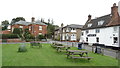
Living in Litcham means settling into a built-up area that spans 24.2 hectares within Norfolk. This small town offers a defined sense of community rather than the sprawling nature of larger cities. You benefit from a compact layout where local amenities remain within practical reach of your home. The area maintains its character as a residential hub where daily life revolves around local needs and established neighbourhood ties. Your surroundings are shaped by decades of growth, creating a stable environment for families and retirees alike. The location stands out for its specific identity rather than broad regional trends. You gain access to a lived-in atmosphere that prioritises convenience over novelty. The town centre acts as the focal point for social interaction and routine errands. Your daily commute or local walk starts from a base defined by clear boundaries and familiar landmarks. This setting appeals to those who value a tangible sense of place within the wider county. Life here balances privacy with proximity, avoiding the isolation of remote villages yet lacking the density of urban districts. You reside in a space designed around human scale, where distance to services remains short. The area provides a consistent backdrop for your lifestyle, whether you work locally or travel to larger centres. Your home offers a connection to Norfolk's broader landscape while maintaining distinct local features.
- Area Type
- Built Up Area 250
- Area Size
- 24.2 hectares
- Population
- Not available
- Population Density
- Not available
Daily life in Litcham revolves around a practical selection of nearby amenities within reaching distance. Retail options number two significant venues, providing essential shopping without requiring long journeys. You will find Budgens Castle and Asda Necton among the stores serving residents. These outlets offer a standard range of groceries, household goods, and daily necessities. This specific retail mix supports a self-sufficient lifestyle where you complete routine shopping locally. You do not need extensive travel to access food or basic goods. The presence of these two major retailers anchors the town's commercial activity. Your weekly shop becomes a manageable task rather than a commitment to a distant supermarket hub. Beyond essential shopping, the area provides a straightforward setting for domestic life. The limited but reliable amenity count ensures that daily errands remain quick and convenient. You spend less time travelling for goods and more time in your immediate surroundings. The local character is defined by this functional access to the essential services you need. This setup suits those who prioritise convenience and proximity in their lifestyle choices.
Amenities
Schools
Families looking at Litcham have access to Litcham School, which operates as both a primary institution and an academy. This single establishment serves multiple educational stages within the same grounds. The academy status indicates a specific accountability framework managed by Ofsted, which has rated the school as good. This rating provides a clear standard of quality for prospective parents. You do not have multiple options within the immediate vicinity, as this academic institution covers most primary needs. The concentration of a good-rated academy simplifies the search for local education. This arrangement ensures that your children have a nearby learning environment meeting government standards. The school represents a central pillar for families settling in this 24.2-hectare community. Litcham School serves as the primary educational anchor for the neighbourhood. Your children will attend an institution with a verified good rating without needing to commute further afield. The combination of primary and academy functions under one name offers administrative simplicity for guardians. This setup supports families who prioritise local schooling for their children's daily commute.
| Rank | School | Type | Entry gender | Ages |
|---|
Explore more schools in this area
Go to Schools tabDemographics
The community in Litcham reflects a mature demographic profile with a median age of 70 years. This statistic indicates a population heavily weighted toward retirees and older adults. The most common age group aligns with household totals, suggesting stability rather than rapid turnover. You are likely to encounter neighbours who have built long-term roots in the area. This age distribution shapes the local energy and pace of life significantly. Home ownership stands at 66% of households, representing a clear majority of residents. This high rate suggests a settled population with established tenure rather than a fluctuating rental market. The remaining segment comprises tenants or those with different ownership statuses. Your neighbours likely view their homes as long-term investments and community anchors. This ownership structure fosters a distinct sense of local attachment and stewardship. Ethnic diversity and religious composition data are not quantified in available records, meaning the area maintains its specific demographic character based on historical settlement patterns. You will find a community defined by shared local history rather than recent migration statistics. This backdrop supports a traditional community feel where longstanding residents play a central role. The demographics create a homogeneous yet stable environment.
Household Size
Accommodation Type
Tenure
Ethnic Group
Religion
Household Composition
Age
Household Deprivation
NS-SEC
Explore more demographic insights in this area
Go to Demographics tabPlanning
Planning Constraints
- Crime RiskPremium