Area Overview for Layer-de-la-Haye
Photos of Layer-de-la-Haye


Area Information
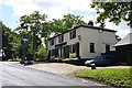
Layer-de-la-Haye is a compact built-up area covering just 1.1 square kilometres in England. Despite its small physical footprint, the neighbourhood supports a distinct local community. You will find that daily life here revolves around a tight-knit demographic where residents often know one another. The area sits closer to larger towns like Colchester, offering easy access to broader retail and transport networks while maintaining a quieter residential character. Living in Layer-de-la-Haye means accepting a defined community size that encourages frequent local interaction. The geographical constraints of the 1.1 km² zone create a concentrated village feel rather than a sprawling urban landscape. This density influences how services are accessed and how quickly news travels through the neighbourhood. Prospective buyers should note that the area functions as a residential hub for those seeking a smaller settlement with wider regional proximity. The location balances quiet suburban living with sufficient infrastructure to meet modern household needs. You will discover a setting where the boundaries between home and local commerce are naturally close. This compact footprint ensures that the character of the area remains consistent throughout all seasons.
- Area Type
- Built Up Area 250
- Area Size
- 1.1 km²
- Population
- Not available
- Population Density
- Not available
The lifestyle available to residents of Layer-de-la-Haye is defined by convenient access to major regional amenities despite the small perimeter. Within practical reach, you can easily visit a Lidl Shrub, an East of England Co-operative Co, or an Asda Colchester. These five retail outlets provide essential groceries and household goods without the need for long journeys. Retail options number five in the immediate vicinity, ensuring daily shopping remains a few minutes away. For transport connections, rail services are well positioned with five stations noted in the practical radius. Key transport hubs include Colchester Town Railway Station, Hythe Railway Station, and Colchester Railway Station. Access to Colchester Town Railway Station specifically links residents directly to the largest station network in the region, facilitating access to major cities like London and Cambridge. This rail connectivity complements the local retail presence, allowing you to manage both domestic errands and city commutes from your doorstep. The mix of five shops and five rail stations creates a balanced lifestyle infrastructure. You do not need to travel far to find food or transit options in Layer-de-la-Haye. The proximity to Asda Colchester and the local Co-operative and Lidl means household finances are protected against high commuting costs. This blend of local quality and regional convenience defines your daily life here.
Amenities
Schools
Families looking at schools near Layer-de-la-Haye have access to specific local provision within the immediate vicinity. The primary option is the Layer-de-la-Haye Church of England Voluntary Controlled Primary School. This institution holds a 'good' Ofsted rating, confirming its standard of education meets national expectations for quality. Being the sole primary school listed in the data for Layer-de-la-Haye suggests a focused local offering for younger children. Families choosing homes in this area should note that this is the designated local primary provider mentioned in the records. For older children, secondary education options are not explicitly detailed in the provided information for this specific built-up area. The presence of a single listed primary school with a 'good' rating provides a clear anchor for parents deciding on Layer-de-la-Haye for their children's upbringing. You need to plan ahead regarding secondary school catchments if you purchase a property here, as no secondary schools are named in the current data. The reliance on this one primary school highlights the small-school tradition often found in 1.1 km² built-up areas. While the 'good' rating is reassuring, the lack of diverse secondary options listed suggests residents may rely on larger nearby towns for older education stages. This is a factual consideration for any family using schools as a primary driver for their property search.
| Rank | School | Type | Entry gender | Ages |
|---|
Explore more schools in this area
Go to Schools tabDemographics
The population profile of Layer-de-la-Haye indicates a mature community with a median age of 70 years. This demographic skew towards older residents shapes the daily rhythm of the area and influences local service demand. The most common age category recorded is simply listed as total, suggesting a broad distribution of ages around this high median. Home ownership stands at a commanding 75% of households within Layer-de-la-Haye. This high ownership rate speaks to a settled population with long-term roots in the district. When considering homes in Layer-de-la-Haye, you should expect a significant presence of privately owned properties rather than rental flats. The accommodation types and ethnic composition details are recorded as total figures, reflecting the comprehensive nature of the available census-style data. Religion breakdowns similarly appear as total categories rather than specific denominational splits. These demographic facts paint a picture of stability. You will not find the high turnover typical of student town centres or young professional hubs here. Instead, the area caters to those in later life or families integrating into a quieter, established environment. The 75% ownership statistic alone suggests that buying into this community allows you to join a group of permanent residents who value local permanence. This contrasts sharply with transient rental markets found elsewhere in the region.
Household Size
Accommodation Type
Tenure
Ethnic Group
Religion
Household Composition
Age
Household Deprivation
NS-SEC
Explore more demographic insights in this area
Go to Demographics tabPlanning
Planning Constraints
- Crime RiskPremium