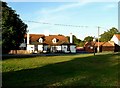
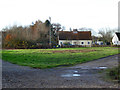
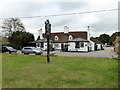
Area Overview for Layer Breton
Photos of Layer Breton


Area Information
Layer Breton is a built-up residential area covering 44.4 hectares in the English countryside. You will find it situated near several key transport links and local shops. The community offers a quiet environment while maintaining access to essential services. Residents can reach Marks Tey Railway Station, Kelvedon Railway Station, and Colchester Town Railway Station within a short drive. This location provides a practical starting point for commuting to larger employment centres without the noise of a major town. The area serves people who value space and tranquility but still require routine access to retail outlets. You can visit a Lidl Shrub, an East of England Co-operative Co, or an Iceland Tiptree at your convenience. These facilities are the primary local retail hubs that support daily needs. The character of Layer Breton balances rural isolation with usable connectivity. People living here often rely on short car journeys for most activities. The size of the locality means it feels distinct from larger urban neighbourhoods. It is a place where you can run a home efficiently while enjoying the benefits of proximity to three train stations. This setup makes sense for families or retirees who need a reliable connection to wider networks without living in the city itself. Your daily life in this built-up area centres on simple logistics and community interaction.
- Area Type
- Built Up Area 250
- Area Size
- 44.4 hectares
- Population
- Not available
- Population Density
- Not available
Daily life in Layer Breton revolves around a curated selection of nearby amenities that are within practical walking or driving distance. You have access to five identified retail venues, led by specific names that form the local high street core. The Lidl Shrub offers affordable grocery options, while the East of England Co-operative Co provides community-focused shopping. The Iceland Tiptree adds another supermarket choice to your weekly routine. For those preferring rail travel, five rail stations serve the broader region. Marks Tey Railway Station, Kelvedon Railway Station, and Colchester Town Railway Station are the key negotiable points for your journey plans. These stations allow you to reach major cities or business districts without residing in them. The concentration of five retail outlets suggests a small but complete local trade network. You do not need to travel far for essential goods or household items. The presence of these specific shops, including the Co-op and Iceland, creates a habitable environment for those who prefer not to drive everywhere. Layer Breton delivers convenience through these named venues, ensuring that basic needs are met locally. The lifestyle here is quiet yet serviced, balancing isolation with accessible commerce.
Amenities
Schools
| Rank | School | Type | Entry gender | Ages |
|---|
Explore more schools in this area
Go to Schools tabDemographics
The population profile of Layer Breton reflects a mature community structure. Your neighbours are on average 70 years old, which is significantly higher than the national figure. This age distribution indicates that the area appeals strongly to retirees rather than young families with school-aged children. Eighty-three per cent of households in Layer Breton own their property outright or with a mortgage. This figure confirms the area is predominantly owner-occupied rather than a rental market. You are unlikely to rent here as a tenant looking for flexible leases. Most accommodation consists of permanent residences, though the specific breakdown of houses versus flats is not detailed in current records. The community composition suggests a stable, long-term population with deep local roots. While specific ethnic data and religious statistics are not currently published for this locality, the demographic skew towards older residents is a clear factual feature. Deprivation levels are not measured for this specific built-up area in the available records, so you cannot use those metrics to evaluate the neighbourhood's economic status. Instead, you should focus on the homogeneity of the age group. Living in Layer Breton means joining an older cohort of residents who have likely lived in their communities for decades. The high home ownership rate of 83% implies a strong sense of local stability and investment in the property stock.
Household Size
Accommodation Type
Tenure
Ethnic Group
Religion
Household Composition
Age
Household Deprivation
NS-SEC
Explore more demographic insights in this area
Go to Demographics tabPlanning
Planning Constraints
- Crime RiskPremium