Area Overview for Kirby-le-Soken & Hamford Ward
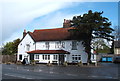
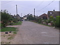
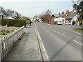
Photos of Kirby-le-Soken & Hamford Ward


Area Information
Kirby-le-Soken & Hamford Ward sits within the Tendring district of Essex, covering a total area of 4.3 km². This district borough unitary ward encompasses the village of Kirby-le-Soken and the Hamford area. At the 2021 census, the built-up area recorded a population of 1,232. The village is located to the west of Frinton-on-Sea and Walton-on-the-Naze. It stands separated from nearby Kirby Cross and neighbouring towns by open fields as part of the wider region known as The Sokens. Historically, the parish once included great Holland and surrounding rural lands before administrative changes in 1934. Today, you will find a settlement defined by its two pubs and two churches. The community hosts an annual Grand village fête on the last bank holiday of the year, featuring dog shows and old carnival games. Living in Kirby-le-Soken & Hamford Ward means experiencing a village life with a millennium forest within close reach. The area offers a quiet existence where specific local amenities shape daily routines rather than distant high streets. Your life here revolves around established traditions and a compact geographical footprint that keeps neighbours relatively close by.
- Area Type
- District Borough Unitary Ward
- Area Size
- 4.3 km²
- Population
- Not available
- Population Density
- Not available
Demographics
The community in Kirby-le-Soken & Hamford Ward shows a distinctly older demographic profile. You will find the median age of residents is 70 years old. This indicates that the majority of those living here fall into advanced age brackets. The data reveals no specific age range breakdown other than the total count, confirming a population heavily weighted towards seniors. Home ownership is a dominant feature of living in this ward, with an 84% home ownership rate. This high figure suggests that most families own their homes outright or have significant mortgage-equity positions. Household composition and accommodation type data are recorded as totals without further breakdown, reinforcing the static nature of the population over time. There are no specific percentages for predominant ethnic groups, religion, or specific household sizes available to quantify diversity. The population structure points to retirement living or long-term residents who have remained in the area for decades. You can expect a neighbourhood where property acts as a legacy asset rather than a primary investment vehicle for transient buyers.
Household Size
Accommodation Type
Tenure
Ethnic Group
Religion
Household Composition
Age
Household Deprivation
NS-SEC
Explore more demographic insights in this area
Go to Demographics tabPlanning
Planning Constraints
- Flood RiskPremium
- Ramsar Wetland SitesPremium
- Area of Outstanding Natural BeautyPremium
- Protected WoodlandPremium
- Crime RiskPremium