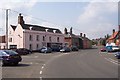
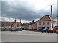
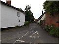
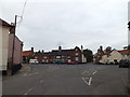
Area Overview for Kenninghall
Photos of Kenninghall


Area Information
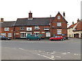
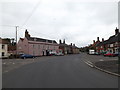
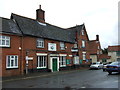
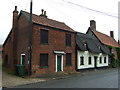
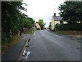
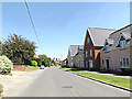
Kenninghall is a built-up area with a total footprint of 39.7 hectares in England. It functions as a local residential cluster defined by its existing infrastructure and proximity to nearby towns. Residents enjoy a setting that balances country village roots with accessible coastlines. The area's identity remains distinct due to its quiet character and strong sense of locality. Living in Kenninghall means accessing a community where the pace of life accommodates both relaxation and practical travel. The environment supports families who value a residential atmosphere without the congestion of larger urban centres. Daily life here centres on local amenities and the ability to reach broader services quickly. You will encounter a neighbourhood where transport links connect you to Retford, Snetterton, and Attleborough efficiently. The compact size of the area ensures that essential services are within practical reach for most households. This location offers a settled environment where residents can maintain a stable routine. Homes in Kenninghall cater to those seeking a stable community with established provision for daily needs. The area provides a solid foundation for homebuyers looking for privacy combined with connectivity. You can expect a neighbourhood where the focus remains on the quality of residential life rather than commercial development. The built-up nature of the settlement ensures that you are surrounded by established housing rather than expanding rural land.
- Area Type
- Built Up Area 250
- Area Size
- 39.7 hectares
- Population
- Not available
- Population Density
- Not available
Residents of Kenninghall have access to four retail venues within practical reach. East of England Co-operative Co provides essential grocers and household supplies for daily chores. Asda Snetterton offers a larger supermarket option for bulk shopping needs. Sainsburys Attleborough serves as an additional retail outlet, conveniently located near the built-up area. These stores ensure that you can handle weekly shopping without needing to travel great distances. Rail transport adds a modern dimension to your lifestyle with three stations nearby. Eccles Road Railway Station, Harling Road Railway Station, and Attleborough Railway Station connect the neighbourhood to wider regional networks. This transport option allows you to reach hospitals, large retail parks, and cultural venues without driving. The combination of local shops and rail links creates a low-stress environment for managing daily errands. Dining and leisure options are supported by the presence of these major retail anchors. The East of England Co-operative Co and Asda often include café services or community events for local engagement. You can catch a weekly trip to the nearby retailers while also enjoying the quiet of your home. The lifestyle here balances the convenience of having four nearby shops with the peace of a residential zone.
Amenities
Schools
Kenninghall has two primary schools serving the local education needs. Kenninghall Community Primary School stands as one of the neighbourhood institutions dedicated to early years education and primary instruction. Residents also attend Kenninghall Primary School, which holds a Ofsted rating of good. This rating confirms that the school meets established standards for educational quality and student care. The mix of these two primary provision options allows for local catchment planning. Both institutions focus on the primary education stage without offering secondary facilities within these specific names. Families living near Kenninghall must navigate the school catchment areas for both facilities. The Ofsted rating for Kenninghall Primary School provides reassurance that the curriculum meets regulatory expectations. You will find that education provision is centred on primary level within the immediate vicinity. If you are considering a home with a view to sending children to school, you must verify the specific catchment boundaries of each institution. The presence of these two schools ensures that primary education is accessible without needing to travel far from the residential streets. The data confirms a functional primary education network serving the area without listing competing secondary options in the immediate neighbourhood.
| Rank | School | Type | Entry gender | Ages |
|---|
Explore more schools in this area
Go to Schools tabDemographics
The community in Kenninghall presents a clear profile based on established resident patterns. The median age for the population is 70 years old, indicating a significant presence of older residents. This demographic reality shapes the local services, social groups, and general pace of daily life. Most households fall into the total age category distribution common for this type of established settlement. Home ownership stands at 76 per cent, establishing a stable environment where the majority of residents own their properties outright or with a mortgage. This high rate of ownership suggests long-term settlement rather than a transient rental population. Accommodation types remain consistent with this ownership model, prioritising stability for families and individuals. The demographic makeup reflects a preference for staying in one location for extended periods. You will find a community where established networks support daily interactions and mutual aid. The high level of home ownership correlates with a desire for permanence and local investment. Residents likely value the quiet atmosphere that comes with an older population. The demographic data confirms that this is a settled area where people build lives rather than passing through. The total age breakdown supports the view of a mature neighbourhood focused on companionship and stability.
Household Size
Accommodation Type
Tenure
Ethnic Group
Religion
Household Composition
Age
Household Deprivation
NS-SEC
Explore more demographic insights in this area
Go to Demographics tabPlanning
Planning Constraints
- Crime RiskPremium