Area Overview for Kelshall
Photos of Kelshall


Area Information
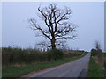
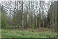
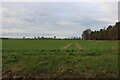
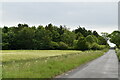
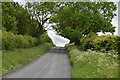
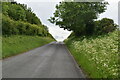
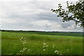
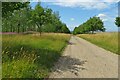
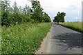
Kelshall is a civil parish in England spanning 9.6 km², offering a distinctively quiet rural setting for those seeking space away from urban congestion. Living in Kelshall means navigating a landscape defined by its small physical footprint and established countryside character. The area attracts individuals who value traditional village life over metropolitan pace, evidenced by a high level of local commitment to the community. Daily life here revolves around proximity to open spaces and a sense of stillness that contrasts sharply with larger towns. You can expect a neighbourhood where the environment dictates the rhythm of the day rather than traffic or commuter pressures. This parish provides a stable backdrop for residents who have already established roots or are looking to buy into a established, low-density community. The compact nature of the area ensures that local services and neighbours are within easy reach, fostering a self-contained lifestyle. Whether you are considering homes in Kelshall for a long-term investment or a retirement retreat, the terrain offers a straightforward, unpretentious geography without the complications of sprawling suburban development. The defining attribute of the area is its manageable scale, which allows for deep familiarity with the surroundings without requiring extensive travel for daily necessities.
- Area Type
- Parish
- Area Size
- 9.6 km²
- Population
- Not available
- Population Density
- Not available
Demographics
The community in Kelshall reflects a mature population profile, with a median age of 70 years. This figure indicates that the majority of residents are older adults, likely including retirees and those who have lived in the parish for decades. Most common age data suggests a demographic skew towards the elderly, which shapes the local economy and social needs around accessibility and leisure rather than youth-centric amenities. Home ownership stands at 69%, meaning nearly seven out of ten residents own their properties outright or with a mortgage. This high ownership rate signals stability and long-term residency, as opposed to a transient rental market. Household composition and accommodation type statistics further support the view of a settled, older demographic living in places designed for their life stage. While specific data on predominant ethnic groups and religious affiliation is not detailed in the current records, the age structure suggests a homogenous, traditional community. Deprivation levels are not explicitly quantified, but the high home ownership often correlates with financial stability among older generations. You should expect a quiet residential environment where neighbours know one another well, driven by the fact that so many people have raised families or retired within the parish boundaries.
Household Size
Accommodation Type
Tenure
Ethnic Group
Religion
Household Composition
Age
Household Deprivation
NS-SEC
Explore more demographic insights in this area
Go to Demographics tabPlanning
Planning Constraints
- Flood RiskPremium
- Ramsar Wetland SitesPremium
- Area of Outstanding Natural BeautyPremium
- Protected Nature ReservePremium
- Protected WoodlandPremium
- Crime RiskPremium