Area Overview for IP4 5AP
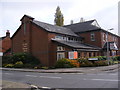
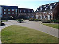
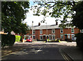
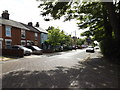
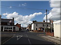
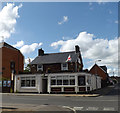
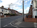
Photos of IP4 5AP

Area Information
Living in IP4 5AP means being part of a small, tightly knit residential cluster in England, home to 1,523 people. This postcode area is defined by its compact size and proximity to essential services, making it practical for daily life. The community here skews towards adults aged 30–64, reflecting a mature demographic with a median age of 47. Most residents own their homes, with 58% of properties in private ownership, and the area is dominated by houses rather than flats. While it lacks the density of larger towns, IP4 5AP offers a quiet, stable environment. Nearby, five rail stations—including Derby Road Railway Station—connect residents to broader networks, while local retail options like Tesco Ipswich and Aldi South provide convenience. The area’s low crime risk and absence of environmental constraints such as AONB or Ramsar sites suggest a straightforward, unobstructed lifestyle. For those seeking a balance between seclusion and accessibility, IP4 5AP presents a pragmatic choice.
- Area Type
- Postcode
- Area Size
- Not available
- Population
- 1523
- Population Density
- 7472 people/km²
IP4 5AP is primarily an owner-occupied area, with 58% of properties in private hands. The housing stock is dominated by houses, which are more common than flats, reflecting a preference for standalone homes. This makes the area appealing to families or individuals seeking space and privacy. As a small postcode covering a residential cluster, the property market is likely limited in scale, with fewer options compared to larger towns. The dominance of owner-occupied homes suggests a stable, long-term market rather than a rental-focused one. Buyers should consider that the area’s compact size may mean competition for available properties. The lack of planning constraints, such as AONB or protected sites, also means fewer restrictions on property modifications or extensions. For those prioritising traditional housing and a low-risk environment, IP4 5AP offers a straightforward proposition.
House Prices in IP4 5AP
No properties found in this postcode.
Energy Efficiency in IP4 5AP
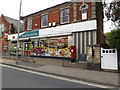
The lifestyle in IP4 5AP is shaped by its proximity to practical amenities. Local retail options, including Tesco Ipswich, Aldi South, and the East of England Co-operative Co, provide everyday shopping needs within walking distance. These stores cater to a range of budgets and preferences, from bulk purchases to fresh produce. The area’s rail stations, such as Entrance2 and Entrance3, offer easy access to broader networks, facilitating travel to nearby towns and cities. While there are no named parks or leisure facilities in the data, the absence of environmental constraints like AONB or protected woodlands suggests open spaces may be available nearby. The combination of retail convenience and rail connectivity creates a functional, low-stress environment. For residents, this means a lifestyle focused on practicality, with minimal effort required for daily errands or travel.
Amenities
Schools
The nearest school to IP4 5AP is Clifford Road Primary School & Nursery, which serves the local community with a primary education offering. Its Ofsted rating is satisfactory, indicating a school that meets basic standards but may not excel in areas like pupil outcomes or leadership. As the only named school in the vicinity, it is a critical factor for families with young children. The absence of secondary schools or specialist institutions means parents may need to look further afield for secondary education. However, the proximity of this primary school reduces commuting time and supports a walkable, family-friendly environment. For those prioritising immediate access to education, Clifford Road Primary School & Nursery provides a foundational resource, though additional research into nearby secondary options would be necessary.
| Rank | School | Type | Entry gender | Ages |
|---|
Explore more schools in this area
Go to Schools tabDemographics
The population of IP4 5AP is predominantly adults aged 30–64, with a median age of 47. This suggests a community of established professionals and families, rather than a younger or elderly demographic. Home ownership is strong, with 58% of residents living in properties they own, compared to 42% renting. The area is characterised by houses rather than flats, indicating a preference for larger, more traditional dwellings. The predominant ethnic group is White, which aligns with broader regional patterns. While no specific data on deprivation is provided, the high home ownership rate and low crime risk imply a relatively stable economic environment. The absence of significant demographic diversity may appeal to those seeking a homogeneous community, though it also means limited exposure to multicultural influences. For buyers, this profile suggests a mature market with properties tailored to long-term occupancy rather than short-term investment.
Household Size
Accommodation Type
Tenure
Ethnic Group
Religion
Household Composition
Age
Household Deprivation
NS-SEC
Explore more demographic insights in this area
Go to Demographics tabPlanning
Planning Constraints
- Flood RiskPremium
- Ramsar Wetland SitesPremium
- Area of Outstanding Natural BeautyPremium
- Protected Nature ReservePremium
- Protected WoodlandPremium