Area Overview for IP33 2QY
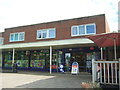
Photos of IP33 2QY


Area Information
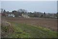
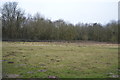
Living in IP33 2QY means being part of a compact, residential community in the heart of England. This postcode area covers just 7.1 hectares, housing 1,624 people in a dense population of 935 people per square kilometre. The area’s small size creates a tight-knit feel, with homes clustered closely together. Daily life here is shaped by proximity to essential services, including four rail stations—Entrance, Bury St Edmunds, and Thurston—offering easy access to nearby towns. Retail options are varied, with M&S West, Morrisons Daily Bury, and Tesco Bury St Edmunds within practical reach. The area’s character is defined by its mix of practicality and accessibility, making it suitable for those seeking a balance between suburban comfort and urban convenience. While it lacks large-scale amenities, its compact nature ensures residents can meet most needs locally. The demographic profile—predominantly adults aged 30–64, with a high rate of home ownership—suggests a stable, established community. For buyers, IP33 2QY offers a snapshot of a lived-in, functional neighbourhood with clear advantages and challenges.
- Area Type
- Postcode
- Area Size
- 7.1 hectares
- Population
- 1624
- Population Density
- 935 people/km²
The property market in IP33 2QY is dominated by owner-occupied homes, with 82% of residents living in properties they own. This contrasts with areas where rental markets are more prominent, indicating a community focused on long-term residency. The accommodation type is predominantly houses, which are likely to be family homes given the median age of 47 and the prevalence of adult households. This suggests a housing stock that prioritises space and privacy over density, making it less suited to young professionals or students seeking smaller, more affordable units. For buyers, the small area size and high population density mean the market is limited in scope, with properties likely to be in close proximity to one another. Prospective buyers should consider the lack of larger developments, as the area’s compact nature restricts expansion. The high home ownership rate also implies a competitive market, where properties may hold value due to their scarcity.
House Prices in IP33 2QY
No properties found in this postcode.
Energy Efficiency in IP33 2QY
Residents of IP33 2QY have access to a range of nearby amenities that support daily life. Retail options include M&S West, Morrisons Daily Bury, and Tesco Bury St Edmunds, providing essential shopping and dining choices. These stores cater to both routine needs and occasional indulgence, ensuring residents can manage errands without long trips. The rail network, with stations such as Entrance and Bury St Edmunds, offers direct links to larger towns, enhancing access to further leisure and employment opportunities. While the area lacks large parks or recreational spaces, its proximity to rail lines suggests nearby green spaces in adjacent towns. The compact layout means amenities are within walking or short driving distance, fostering a convenient, self-contained lifestyle. However, the absence of named parks or leisure facilities within the postcode itself means residents may need to travel slightly to enjoy outdoor activities.
Amenities
Schools
| Rank | School | Type | Entry gender | Ages |
|---|
Explore more schools in this area
Go to Schools tabDemographics
The community in IP33 2QY is predominantly composed of adults aged 30–64, with a median age of 47. This suggests a mature population, likely with long-term ties to the area. Home ownership is high, at 82%, indicating a strong preference for property as an asset. The accommodation type is primarily houses, reflecting a residential profile focused on family homes rather than flats or apartments. The predominant ethnic group is White, with no data provided on other demographics. The population density of 935 people per square kilometre is notably high for such a small area, which may influence the character of local interactions and the demand for shared resources. While no specific deprivation data is mentioned, the high home ownership rate and stable age profile suggest a community with relatively consistent economic stability. However, the absence of detailed diversity metrics means broader social dynamics remain unexplored.
Household Size
Accommodation Type
Tenure
Ethnic Group
Religion
Household Composition
Age
Household Deprivation
NS-SEC
Explore more demographic insights in this area
Go to Demographics tabPlanning
Planning Constraints
- Flood RiskPremium
- Ramsar Wetland SitesPremium
- Area of Outstanding Natural BeautyPremium
- Protected Nature ReservePremium
- Protected WoodlandPremium
- Crime RiskPremium