Area Overview for IP30 0QF
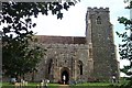
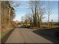
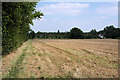
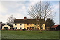
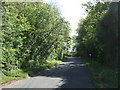
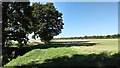
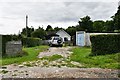
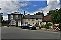
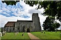
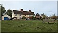
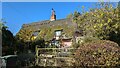
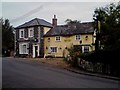
Photos of IP30 0QF
Area Information
Living in IP30 0QF offers a quiet, low-density lifestyle within a small residential cluster spanning 20.6 hectares. With a population of 2,149 and a density of 69 people per square kilometre, the area feels uncluttered, ideal for those seeking space without isolation. The community is predominantly composed of adults aged 30–64, with a median age of 47, suggesting a mature, stable demographic. Home ownership is high at 79%, reflecting a strong sense of local roots. The area’s compact size means amenities and services are within practical reach, while its proximity to rail networks and schools adds convenience. IP30 0QF is not a sprawling suburb but a focused neighbourhood, where daily life balances simplicity with accessibility. For buyers, this is a place where privacy and community coexist, with minimal environmental constraints and a low crime risk. The absence of major planning restrictions or flood risks further enhances its appeal for long-term residency.
- Area Type
- Postcode
- Area Size
- 20.6 hectares
- Population
- 2149
- Population Density
- 69 people/km²
IP30 0QF is primarily an owner-occupied area, with 79% of homes owned by residents rather than rented. The accommodation type is predominantly houses, which aligns with the low population density and the area’s character as a small residential cluster. This suggests a market where properties are likely to be family homes rather than investment properties. The compact size of the area—20.6 hectares—means the housing stock is limited, which could make the local market competitive for buyers. For those considering the area, the high home ownership rate indicates a stable environment with little turnover. However, the small size also means that buyers should look beyond the immediate postcode to explore nearby options. The absence of major planning constraints or environmental risks further supports the area’s appeal for long-term homeownership.
House Prices in IP30 0QF
Showing 7 properties
| Address | Type | Beds | Baths | Last Sale Price | Last Sale Date | |
|---|---|---|---|---|---|---|
| Clematis Cottage, Felsham Road, Gedding, IP30 0QF | house | 3 | - | £229,000 | Jan 2012 | |
| Boundary Farm, Drinkstone Road, Gedding, IP30 0QF | house | - | - | £395,000 | Dec 2005 | |
| Hazel Cottage, Felsham Road, Gedding, IP30 0QF | Detached | - | - | £45,050 | Dec 1995 | |
| Tye House, Bury Road, Gedding, IP30 0QF | Detached | 4 | 2 | - | - | |
| Twenty Twenty View, Felsham Road, Gedding, IP30 0QF | house | - | - | - | - | |
| 2, Gedding Corner, Drinkstone Road, Gedding, IP30 0QF | Semi-detached | - | - | - | - | |
| 1, Gedding Corner, Drinkstone Road, Gedding, IP30 0QF | Semi-detached | - | - | - | - |
Energy Efficiency in IP30 0QF
Residents of IP30 0QF have access to a modest range of amenities within practical reach. The area includes five retail outlets, notably East of England Co-operative Co and Co-op Thurston, offering basic shopping and services. These stores suggest a functional but limited retail environment, suitable for everyday needs but lacking in variety. The rail network is well-served, with four stations—Thurston, Elmswell, and others—providing connections to nearby towns and cities. This makes commuting or weekend travel feasible. The area’s small size means the focus is on convenience rather than diversity, with no mention of parks, leisure facilities, or dining options in the data. For those valuing proximity to essentials and transport, IP30 0QF delivers, but it is not a hub for entertainment or leisure.
Amenities
Schools
Residents of IP30 0QF have access to two primary schools: Rattlesden Church of England Voluntary Controlled School and Rattlesden Church of England Primary Academy. Both are primary institutions, catering to younger children, though no secondary schools are listed in the data. The latter school has an Ofsted rating of 'good', indicating a reliable standard of education. The presence of two primary schools within reach is a significant advantage for families, reducing the need to travel for schooling. However, the absence of secondary education options means parents may need to consider proximity to larger towns for high school. The mix of schools suggests a focus on early education, which is typical in smaller communities. For buyers prioritising schools, this area offers immediate access to primary education but requires planning for secondary schooling.
| Rank | School | Type | Entry gender | Ages |
|---|
Explore more schools in this area
Go to Schools tabDemographics
The population of IP30 0QF is 2,149, with a median age of 47, indicating a mature, established community. The most common age range is 30–64, suggesting a mix of middle-aged professionals and families. Home ownership is high at 79%, with the majority of properties being houses rather than flats. The predominant ethnic group is White, reflecting a homogenous demographic. This profile points to a stable, low-turnover area where residents are likely to have long-term ties. The low population density of 69 people per square kilometre means the area avoids the congestion of larger towns. For buyers, this demographic suggests a community with strong local identity and minimal pressure from transient populations. The data also implies that the area is not a hotspot for deprivation, as the population is largely composed of working-age adults with established housing.
Household Size
Accommodation Type
Tenure
Ethnic Group
Religion
Household Composition
Age
Household Deprivation
NS-SEC
Explore more demographic insights in this area
Go to Demographics tabPlanning
Planning Constraints
- Flood RiskPremium
- Ramsar Wetland SitesPremium
- Area of Outstanding Natural BeautyPremium
- Protected Nature ReservePremium
- Protected WoodlandPremium