Area Overview for IP22 4NG
Photos of IP22 4NG
Area Information
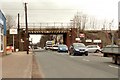
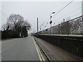
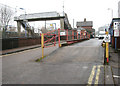
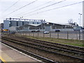
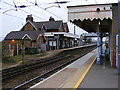
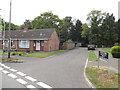
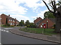
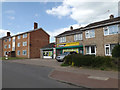
Living in IP22 4NG means inhabiting a compact, residential cluster in England’s eastern region, where 2,138 people reside across a densely populated area. With 1,621 people per square kilometre, this postcode reflects a tight-knit community, likely centred around local amenities and transport links. The area’s character is defined by its proximity to Diss Railway Station, offering easy access to regional travel, and a cluster of retail outlets including Tesco, Morrisons, and Aldi, suggesting a practical, everyday convenience. While the data does not specify historical or cultural landmarks, the presence of a single special school and low safety risks indicate a focus on functional living. This is a place where daily life revolves around proximity to essential services, with a mature demographic profile shaping its pace and priorities. For those seeking a quiet, residential environment without the sprawl of larger towns, IP22 4NG offers a compact, manageable footprint.
- Area Type
- Postcode
- Area Size
- Not available
- Population
- 2138
- Population Density
- 1621 people/km²
The property market in IP22 4NG is characterised by a high proportion of owner-occupied homes, with 59% of residents owning their properties. This suggests a stable market where long-term residency is common, rather than a transient rental-driven environment. The accommodation type is predominantly houses, which may reflect a preference for private, standalone living in a small, residential cluster. Given the area’s compact size, the housing stock is likely limited, making it a niche market for buyers seeking a quiet, low-density setting. The lack of data on property prices or recent transactions means the market’s competitiveness cannot be assessed, but the focus on home ownership and houses indicates a community prioritising security and space over high turnover.
House Prices in IP22 4NG
No properties found in this postcode.
Energy Efficiency in IP22 4NG
The lifestyle in IP22 4NG is shaped by its nearby retail options, including Tesco, Morrisons, and Aldi in Diss. These stores provide essential shopping convenience, reducing the need for long trips to larger towns. While the data does not mention parks, leisure facilities, or dining venues, the presence of multiple retail outlets suggests a focus on practicality over recreation. The area’s compact size likely fosters a community-oriented atmosphere, where local amenities serve daily needs. However, without specific details on leisure or cultural offerings, the full breadth of lifestyle options remains unclear.
Amenities
Schools
The only school explicitly mentioned near IP22 4NG is Kadesh Education, a special school. No other schools are listed in the data, meaning families reliant on mainstream education for children may need to look beyond the immediate area. The presence of a special school suggests the community may cater to specific educational needs, but it does not provide a comprehensive range of schooling options. For families requiring primary or secondary education, the proximity of Kadesh Education alone may not suffice, necessitating reliance on nearby towns or districts for broader school choices.
| Rank | School | Type | Entry gender | Ages |
|---|
Explore more schools in this area
Go to Schools tabDemographics
The population of IP22 4NG skews towards adults aged 30–64, with a median age of 47. This suggests a community of established professionals and families, rather than a younger or retired demographic. Home ownership is strong, with 59% of residents owning their properties, indicating a stable, long-term presence. The accommodation type is predominantly houses, which aligns with the area’s low population density and suggests a preference for private, standalone living. The predominant ethnic group is White, with no data provided on other demographics. The absence of specific deprivation metrics means the quality of life cannot be assessed in terms of socioeconomic challenges, but the high home ownership and mature age profile imply a relatively settled, low-turnover community.
Household Size
Accommodation Type
Tenure
Ethnic Group
Religion
Household Composition
Age
Household Deprivation
NS-SEC
Explore more demographic insights in this area
Go to Demographics tabPlanning
Planning Constraints
- Flood RiskPremium
- Ramsar Wetland SitesPremium
- Area of Outstanding Natural BeautyPremium
- Protected Nature ReservePremium
- Protected WoodlandPremium