Area Overview for IP2 8SN
Photos of IP2 8SN


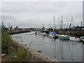


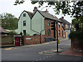
100 photos from this area
Area Information
Key information about the IP2 8SN including its size, population, and administrative classification.
- Area Type
- Postcode
- Area Size
- 1890 m²
- Population
- 2307
- Population Density
- 6629 people/km²
House Prices in IP2 8SN
40
Properties
£156,241
Average Sold Price
£100,000
Lowest Price
£320,000
Highest Price
Showing 40 properties
| Address | Type | Beds | Baths | Last Sale Price | Last Sale Date | |
|---|---|---|---|---|---|---|
| 125 Stoke Quay, Ipswich, IP2 8SN | Flat | 1 | - | £110,000 | Sep 2022 | |
| 123 Stoke Quay, Ipswich, IP2 8SN | Flat | 1 | 1 | £127,000 | Sep 2022 | |
| 121 Stoke Quay, Ipswich, IP2 8SN | Flat | - | - | £140,000 | Sep 2021 | |
| 155 Stoke Quay, Ipswich, IP2 8SN | Flat | - | - | £320,000 | Mar 2021 | |
| 143 Stoke Quay, Ipswich, IP2 8SN | Flat | 1 | 1 | £120,000 | Jul 2020 | |
| 113 Stoke Quay, Ipswich, IP2 8SN | Flat | 1 | 1 | £117,000 | May 2018 | |
| 127 Stoke Quay, Ipswich, IP2 8SN | Flat | - | - | £140,000 | Apr 2017 | |
| 115 Stoke Quay, Ipswich, IP2 8SN | Flat | - | - | £116,500 | Mar 2017 | |
| 105 Stoke Quay, Ipswich, IP2 8SN | Flat | - | - | £105,000 | Feb 2017 | |
| 111 Stoke Quay, Ipswich, IP2 8SN | Flat | - | - | £112,000 | Jan 2016 |
Page 1 of 4
Energy Efficiency in IP2 8SN
Amenities
Schools
| Rank | School | Type | Entry gender | Ages |
|---|
Explore more schools in this area
Go to Schools tabDemographics
Household Size
One person
most common
Accommodation Type
Flats
most common
Tenure
21
majority
Ethnic Group
White
most common
Religion
N/A
most common
Household Composition
N/A
most common
Age
22
median
Adults (30-64 years)
most common
Household Deprivation
N/A
with no deprivation
NS-SEC
22
in Lower managerial occupations
Explore more demographic insights in this area
Go to Demographics tabPlanning
Planning Constraints
- Flood RiskPremium
- Ramsar Wetland SitesPremium
- Area of Outstanding Natural BeautyPremium
- Protected Nature ReservePremium
- Protected WoodlandPremium