Area Overview for IP18 6NE
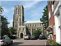
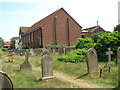
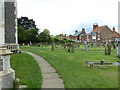
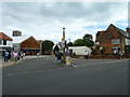
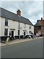
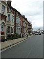
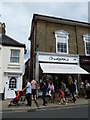
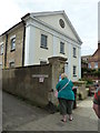
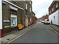
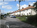
Photos of IP18 6NE


Area Information
Living in IP18 6NE means being part of a small, tightly knit residential cluster in eastern England. With a population of 2,178 and a density of 585 people per square kilometre, the area is compact yet functional, offering a quiet contrast to larger urban centres. The community here skews towards older residents, with a median age of 47 and a significant proportion of those aged 65 and above. This demographic shape suggests a stable, long-term presence, with 77% of homes owner-occupied. The area’s character is defined by its proximity to coastal amenities, including ferry landings at Southwold and Walberswick, which connect residents to nearby towns and natural landscapes. Daily life is shaped by the availability of local shops, such as Co-op Southwold and Tesco Southwold, and the presence of two primary schools with good Ofsted ratings. While the area lacks large-scale infrastructure, its small size and low population density create a sense of intimacy, ideal for those seeking a peaceful, low-traffic environment.
- Area Type
- Postcode
- Area Size
- Not available
- Population
- 2178
- Population Density
- 585 people/km²
The property market in IP18 6NE is dominated by owner-occupied homes, with 77% of properties in private hands. This suggests a stable, long-term market with limited rental activity, which may appeal to buyers seeking investment security or a place to settle permanently. The accommodation type is predominantly houses, which aligns with the area’s demographic profile of older residents who may prefer the space and privacy they offer. Given the small size of the postcode area and its low population density, the housing stock is likely limited to a few distinct properties rather than a large selection. Buyers should consider that the market is not highly dynamic, with fewer new developments or speculative opportunities. For those prioritising a quiet, established home, IP18 6NE offers a niche option, but its small size means competition for properties may be limited.
House Prices in IP18 6NE
No properties found in this postcode.
Energy Efficiency in IP18 6NE
The lifestyle in IP18 6NE is shaped by its small-scale retail and coastal access. Local shops such as Co-op Southwold, Tesco Southwold, and East of England Co-operative Co provide essentials, while the ferry landings at Southwold and Walberswick connect residents to the surrounding area. These amenities support a practical, low-maintenance lifestyle, ideal for those who prefer proximity to nature and minimal urban sprawl. The absence of large leisure facilities or parks means recreation is likely centred on nearby coastal walks or community events. The area’s charm lies in its simplicity, offering a quiet alternative to busier regions, with amenities tailored to the needs of its older population and those who value convenience over scale.
Amenities
Schools
Residents of IP18 6NE have access to a range of educational options, including Southwold Primary School and Reydon Primary School, both of which hold a good Ofsted rating. These state-funded institutions provide a solid foundation for younger children, while Eversley School, an independent institution, offers an alternative for families seeking a different educational approach. The presence of two primary schools with strong evaluations suggests a commitment to quality education in the area, though no secondary schools are listed. The mix of state and independent options allows families to choose between affordability and specialised curricula. For parents, the proximity of these schools within practical reach of the postcode area is a key consideration, ensuring ease of access for daily commutes.
| Rank | School | Type | Entry gender | Ages |
|---|
Explore more schools in this area
Go to Schools tabDemographics
The community in IP18 6NE is predominantly composed of individuals aged 65 and over, with a median age of 47. This suggests a population that is largely settled, with fewer young families or transient residents. Home ownership is high at 77%, indicating a strong local presence and reduced turnover. The area is characterised by houses rather than flats, which aligns with the demographic profile of older residents who may prefer larger properties. The predominant ethnic group is White, reflecting a homogenous community. While no specific deprivation data is provided, the high home ownership rate and stable age distribution imply a relatively consistent quality of life, with fewer pressures from economic hardship. The absence of significant diversity metrics means the area’s social fabric is shaped primarily by its elderly population and long-standing residents.
Household Size
Accommodation Type
Tenure
Ethnic Group
Religion
Household Composition
Age
Household Deprivation
NS-SEC
Explore more demographic insights in this area
Go to Demographics tabPlanning
Planning Constraints
- Flood RiskPremium
- Ramsar Wetland SitesPremium
- Area of Outstanding Natural BeautyPremium
- Protected Nature ReservePremium
- Protected WoodlandPremium