Area Overview for IP1 4PL
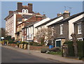
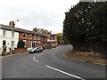
Photos of IP1 4PL


Area Information
Living in IP1 4PL means being part of a small, tightly knit residential cluster in eastern England. With a population of 1972, the area is compact, offering a quiet, low-density lifestyle. The community is predominantly composed of adults aged 30–64, reflecting a mature demographic. Daily life here is shaped by proximity to local amenities, including retail outlets like Iceland Ipswich and Morrisons Daily, as well as rail links to Ipswich and Westerfield stations. The area’s modest size means it is easy to navigate on foot or by bike, with no major roads or motorways nearby. While it lacks the vibrancy of larger towns, its simplicity and accessibility make it appealing for those seeking a peaceful, stable environment. Families benefit from St Margaret’s Church of England Primary School, which has a good Ofsted rating. For commuters, the nearby rail stations provide reliable connections to regional hubs. IP1 4PL is not a place for those craving urban energy but suits those prioritising tranquillity and practicality.
- Area Type
- Postcode
- Area Size
- Not available
- Population
- 1972
- Population Density
- 4496 people/km²
IP1 4PL’s property market is defined by a 38% home ownership rate, which is lower than the national average, suggesting a higher reliance on rental properties. The area’s housing stock is predominantly composed of houses rather than flats, indicating a preference for standalone homes in a residential setting. Given the small size of the postcode and its classification as a cluster of homes, the market is likely limited in scale, with few new developments. Buyers should consider that the area’s compact nature means property values may be influenced more by proximity to amenities than by size or condition. The presence of nearby rail stations and retail outlets could enhance desirability, but the modest population and limited infrastructure suggest it is not a high-demand area for investment. For those seeking a quiet, low-maintenance home, IP1 4PL offers a straightforward option, though its small size may restrict choices for buyers looking for larger or more varied properties.
House Prices in IP1 4PL
No properties found in this postcode.
Energy Efficiency in IP1 4PL
The lifestyle in IP1 4PL is shaped by its proximity to essential amenities. Retail options include Iceland Ipswich, Morrisons Daily, and M&S Ipswich, providing convenient access to grocery and household shopping. The presence of multiple rail stations, such as Entrance and Westerfield, enhances connectivity, allowing residents to travel easily to nearby towns and cities. While the area lacks large parks or leisure facilities, the compact layout ensures that daily errands and travel are efficient. The combination of local shops and rail links supports a practical, low-stress lifestyle, ideal for those who prioritise convenience over expansive recreational spaces. The quiet, residential character of the area complements its accessibility, making it suitable for individuals who value simplicity and functional living.
Amenities
Schools
The nearest school to IP1 4PL is St Margaret’s Church of England Voluntary Aided Primary School in Ipswich, which serves the local community. This primary school has an Ofsted rating of ‘good’, indicating a satisfactory standard of education. The absence of secondary schools within the area means families may need to look further afield for secondary education, though the proximity to Ipswich suggests nearby options. The presence of a well-rated primary school is a key asset for families, ensuring access to quality early education. However, the limited range of school types within the postcode may require additional planning for older children. For those prioritising strong foundational education, St Margaret’s provides a reliable starting point, but parents should factor in travel time to secondary schools when considering the area.
| Rank | School | Type | Entry gender | Ages |
|---|---|---|---|---|
| 1 | St Margaret's Church of England Voluntary Aided Primary School, Ipswich | primary | N/A | N/A |
Explore more schools in this area
Go to Schools tabDemographics
The population of IP1 4PL is 1972, with a median age of 47, indicating a community skewed towards middle-aged adults. The most common age range is 30–64, suggesting a stable, established population with fewer young families or retirees. Home ownership rates stand at 38%, which is notably lower than the national average, implying a higher proportion of renters. The area is characterised by houses rather than flats, reflecting a traditional, family-oriented housing stock. The predominant ethnic group is White, with no specific data on other demographics provided. This profile suggests a community that is neither rapidly growing nor highly diverse, with a focus on long-term residents. The absence of detailed deprivation data means quality of life factors such as access to services or employment opportunities are not quantified, but the presence of nearby schools and retail amenities hints at a functional, if unremarkable, local infrastructure.
Household Size
Accommodation Type
Tenure
Ethnic Group
Religion
Household Composition
Age
Household Deprivation
NS-SEC
Explore more demographic insights in this area
Go to Demographics tabPlanning
Planning Constraints
- Flood RiskPremium
- Ramsar Wetland SitesPremium
- Area of Outstanding Natural BeautyPremium
- Protected Nature ReservePremium
- Protected WoodlandPremium
- Crime RiskPremium