Area Overview for IG10 1XB
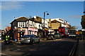
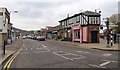
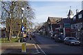
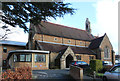
Photos of IG10 1XB


Area Information
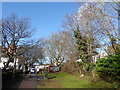
Living in IG10 1XB means being part of a small, residential cluster in England with a population of 1,688. This area is characterised by a mature community, with a median age of 47 and a strong presence of adults aged 30–64. The neighbourhood is predominantly composed of owner-occupied homes, reflecting a stable housing market. Daily life here is shaped by its proximity to key amenities, including multiple schools, transport hubs, and retail outlets. While the area lacks large-scale urban features, its compact size offers a quiet, localised feel. Residents benefit from excellent broadband connectivity, scoring 96 out of 100, ensuring seamless digital access for work or leisure. The area’s transport links, including nearby underground and rail stations, provide easy access to larger towns and cities. However, the community’s character is defined by its balance of practicality and accessibility, making it suitable for those seeking a settled lifestyle without sacrificing connectivity.
- Area Type
- Postcode
- Area Size
- Not available
- Population
- 1688
- Population Density
- 4743 people/km²
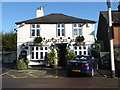
The property market in IG10 1XB is dominated by owner-occupied homes, with 69% of properties owned by residents rather than rented. This suggests a stable, long-term demographic with a focus on family housing. The accommodation type is primarily houses, which may indicate a preference for larger, more private living spaces. As a small area, the housing stock is likely limited in scale, meaning buyers should consider nearby zones for broader options. The high home ownership rate could signal a competitive market, where properties are held by residents for extended periods. For prospective buyers, this environment may offer security but also require patience in finding available listings. The absence of rental data means the extent of the rental market remains unclear, though the emphasis on ownership suggests a community prioritising permanence over transient tenancy.
House Prices in IG10 1XB
No properties found in this postcode.
Energy Efficiency in IG10 1XB
The lifestyle in IG10 1XB is shaped by its proximity to a range of amenities. Retail options include Morrisons Loughton, M&S Loughton, and Cook Loughton, offering everyday shopping needs. The area’s transport links, such as Loughton Underground Station and Brimsdown Rail Station, provide access to larger towns and cities, supporting both commuting and leisure travel. While parks and leisure facilities are not explicitly listed, the presence of multiple schools and transport hubs suggests a focus on community and connectivity. The compact nature of the area means amenities are within practical reach, reducing the need for long journeys. For residents, this balance of retail, transport, and local services contributes to a convenient, functional lifestyle. The area’s character is defined by accessibility and practicality, catering to those who prioritise ease of movement and proximity to essential services.
Amenities
Schools
The area is served by several primary schools, including Staples Road Junior School, Staples Road Infant School, Roding Valley High School, Loughton High School, and Staples Road Primary School. All are primary institutions, catering to younger children and providing a range of educational options for families. While no Ofsted ratings are provided, the presence of multiple schools suggests a focus on accessible, local education. The variety of school names may indicate different specialisms or historical contexts, though specifics are not detailed. For parents, the proximity of these schools reduces commuting time and supports a family-oriented lifestyle. However, the lack of secondary schools in the immediate area means students may need to travel further for higher education. The density of primary schools reflects the community’s emphasis on early education and local infrastructure.
| Rank | School | Type | Entry gender | Ages |
|---|---|---|---|---|
| 1 | Staples Road Junior School | primary | N/A | N/A |
| 2 | Staples Road Infant School | primary | N/A | N/A |
| 3 | Roding Valley High School | primary | N/A | N/A |
| 4 | Loughton High School | primary | N/A | N/A |
| 5 | Staples Road Primary School | primary | N/A | N/A |
Explore more schools in this area
Go to Schools tabDemographics
The community in IG10 1XB is predominantly composed of adults aged 30–64, with a median age of 47. Home ownership is high, at 69%, and the accommodation type is largely houses, suggesting a focus on family homes. The predominant ethnic group is White, though specific diversity metrics are not provided. The age profile indicates a mature population, which may influence local services and amenities. With no data on deprivation, it is unclear how economic factors might affect quality of life. However, the high home ownership rate suggests a degree of financial stability among residents. The absence of detailed diversity statistics means the area’s cultural makeup remains less defined in the data. The population size of 1,688 implies a close-knit community, where social networks and local interactions are likely to be significant.
Household Size
Accommodation Type
Tenure
Ethnic Group
Religion
Household Composition
Age
Household Deprivation
NS-SEC
Explore more demographic insights in this area
Go to Demographics tabPlanning
Planning Constraints
- Flood RiskPremium
- Ramsar Wetland SitesPremium
- Area of Outstanding Natural BeautyPremium
- Protected Nature ReservePremium
- Protected WoodlandPremium
- Crime RiskPremium