Area Overview for Hunston
Photos of Hunston


Area Information
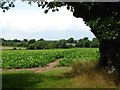
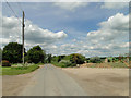
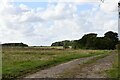
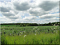
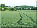
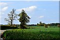
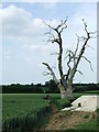
Hunston is a small civil parish located in Mid-Suffolk, covering an area of 3.9 km². Situated approximately eight miles north-west of Stowmarket and a similar distance east of Bury St Edmunds, the village lies between Stowlangtoft and Badwell Ash. The settlement occupies a distinctive geographical position within the High Suffolk claylands. While the surrounding region is characterised by clay, Hunston itself sits in a till-free pocket with exposed gravels and chalk. This geological composition makes the land particularly suitable for arable farming, defining the area's agricultural heritage. The village is surrounded by a designated conservation area established in 1973. This designation reflects the importance of the local built environment, which originally consisted of scattered farmhouses and cottages documented back to the Domesday survey of 1086. Daily life in Hunston reflects its history as a quiet agricultural community. The village pattern is dispersed rather than dense, with timber-framed and plastered houses featuring thatched or plain-tile roofs. Trees remain integrated into the landscape, contributing to a leafy, informal character. You will find the main activity along The Street, a road lined with significant trees protected by Tree Preservation Orders. The area holds archaeological interest, with records of Roman, Saxon, and Medieval artefacts discovered within the parish. The Church of St Michael stands as a Grade II* listed building, recognised for its plastered flint rubble walls. For those seeking a rural lifestyle with historical depth, living in Hunston offers proximity to established transport routes like the A1088 and a railway station 3¼ miles away in Elmswell.
- Area Type
- Parish
- Area Size
- 3.9 km²
- Population
- Not available
- Population Density
- Not available
Demographics
The community profile of Hunston reveals a settlement geared towards older residents. The median age in the parish stands at 70 years, indicating a highly mature population compared to national averages. Your neighbours will primarily consist of people in their later years, creating a neighbourhood that likely prioritises quiet and established routines. This demographic skew suggests a community that may be rooted in long-term local knowledge and tradition. There is no data provided regarding specific age range breakdowns beyond the total median, but the high figure confirms the area's status as a place for retirement or later-life living. Home ownership is a dominant feature of life in Hunston, with 73% of households owning their homes outright or with a mortgage. This high proportion implies stability and a culture of tenure rather than renting. The remaining 27% of the population resides in rented accommodation, which typically consists of smaller-scale properties given the village's historic nature. Specific details on household composition and accommodation types are not broken down further in the available statistics. You will not find a young professional market or student population driving the housing demand here. The demographic reality suggests a consistent, low-traffic environment where long-term residents form the social fabric. Convenience stores and large commercial centres are unlikely to be a feature of daily life, as the community lacks the younger workforce that typically drives such retail growth.
Household Size
Accommodation Type
Tenure
Ethnic Group
Religion
Household Composition
Age
Household Deprivation
NS-SEC
Explore more demographic insights in this area
Go to Demographics tabPlanning
Planning Constraints
- Flood RiskPremium
- Ramsar Wetland SitesPremium
- Area of Outstanding Natural BeautyPremium
- Protected Nature ReservePremium
- Protected WoodlandPremium
- Crime RiskPremium