Area Overview for Hundon
Photos of Hundon
Area Information
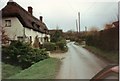
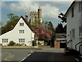
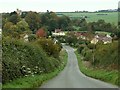
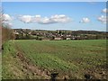
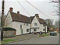
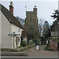
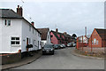
Hundon is a built-up area situated in England, covering a total of 37.4 hectares. You are choosing a small locality where the physical footprint is compact yet established as a residential community. This setting defines the pace of daily life, offering a contained environment rather than the sprawl of a larger city. The area's size suggests that your evening walks will remain local, keeping you close to the streets and fields that surround your future home. Living in Hundon means embracing a settled pattern where the neighbourhood boundaries are distinct and the community scale is manageable. The structure of the area supports a lifestyle where proximity to home is the primary advantage. You will find that the layout encourages a slower, more deliberate routine compared to busier urbanextensions. The specific designation as a built-up area confirms that essential services and housing clusters exist within these 37.4 hectares. When you consider homes in Hundon, you are selecting a place where the boundary between your private garden and the public world remains clear. This definition shapes everything from local governance to the social interactions you will experience with your neighbours.
- Area Type
- Built Up Area 250
- Area Size
- 37.4 hectares
- Population
- Not available
- Population Density
- Not available
Your daily errands in Hundon will rely on amenities found within a short practical reach, as there are no larger commercial precincts inside the 37.4-hectare boundary. Within a few miles, you can access five key retail locations: a Spar, a Co-op in Clare, and Budgens in Haverhill. These specific venues form the core of your shopping routine for groceries, household essentials, and daily necessities. While large supermarkets and cinemas are not present in Hundon itself, these three outlets provide sufficient convenience for a small community. You will plan your broader shopping trips to these named locations rather than walking to a town centre. The presence of these chains ensures that basic needs are met without long distances, which balances well with the area's peaceful character. This arrangement supports a lifestyle where significant purchases happen occasionally at the named supermarkets, while routine items are collected locally. The limited but specific list of retailers defines the operational rhythm of a life in Hundon.
Amenities
Schools
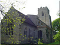
For families with young children, the nearest educational provision is Hundon Community Primary School. This institution serves as the local primary school and holds a Good rating under Ofsted’s framework. The presence of a single primary school within the immediate vicinity defines the educational landscape for this small built-up area. You will find that secondary education is not provided within these immediate boundaries, meaning older children will require bus travel or car journeys to reach comprehensive schools outside Hundon. The school's Good rating offers reassurance regarding the quality of primary education available to local families. This rating is a concrete metric indicating that the school meets the expected standards for student learning and oversight. When planning for your children, you must account for the fact that this is a single-choice option for primary years. The mix of school types, limited to just this primary facility, simplifies choice but reduces variety for parents seeking specific secondary options nearby. Living in Hundon requires an acceptance that all pre-secondary education needs are met centrally within the community.
| Rank | A + A* % | School | Type | Entry gender | Ages |
|---|---|---|---|---|---|
| 1 | N/A | Hundon Community Primary School | primary | N/A | N/A |
Explore more schools in this area
Go to Schools tabDemographics
The community in Hundon is defined by a population with a median age of 70 years. This statistic indicates a settlement where older adults dominate the demographic profile. Home ownership stands at 80%, reflecting a household stability that aligns with the age profile of the residents. You will find that the majority of homes are occupied by owners rather than tenants, creating a sense of permanence within the area. The data highlights that this is a space where people have likely lived for a long time. The specific figure of 80% ownership suggests that buying a home here is often a lifelong investment rather than a temporary rental arrangement. When you examine the household composition, the high median age confirms that this is not a young professional hub or a family-only zone. Instead, it serves as a retirement destination or a place where families may move as they age. The concentration of older demographics shapes local services and social circles, ensuring that the area caters to the needs of seniors. Living in Hundon means joining a group where shared life experiences and similar age ranges create a common ground for interaction.
Household Size
Accommodation Type
Tenure
Ethnic Group
Religion
Household Composition
Age
Household Deprivation
NS-SEC
Explore more demographic insights in this area
Go to Demographics tabPlanning
Planning Constraints
- Crime RiskLocked