Area Overview for HP3 0NA
Photos of HP3 0NA
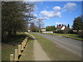
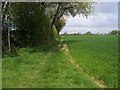
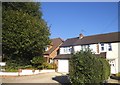
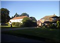


13 photos from this area
Area Information
Key information about the HP3 0NA including its size, population, and administrative classification.
- Area Type
- Postcode
- Area Size
- 36.4 hectares
- Population
- 1369
- Population Density
- 100 people/km²
House Prices in HP3 0NA
25
Properties
£997,722
Average Sold Price
£300,000
Lowest Price
£1,700,000
Highest Price
Showing 25 properties
| Address | Type | Beds | Baths | Last Sale Price | Last Sale Date | |
|---|---|---|---|---|---|---|
| White Lilacs, Water Lane, Bovingdon, Hemel Hempstead, HP3 0NA | Bungalow | 3 | 2 | £890,000 | Oct 2023 | |
| Oakleigh, Water Lane, Bovingdon, Hemel Hempstead, HP3 0NA | Bungalow | - | - | £1,700,000 | Feb 2023 | |
| The Acorn, Water Lane, Bovingdon, Hemel Hempstead, HP3 0NA | Detached | 3 | 2 | £1,517,500 | May 2018 | |
| Four Winds, Water Lane, Bovingdon, Hemel Hempstead, HP3 0NA | Detached | 4 | 3 | £755,000 | Dec 2016 | |
| Elmcote, Water Lane, Bovingdon, Hemel Hempstead, HP3 0NA | Detached | 3 | 1 | £492,000 | Feb 2015 | |
| Water Lane Cottage, Water Lane, Bovingdon, Hemel Hempstead, HP3 0NA | house | - | - | £675,000 | Sep 2010 | |
| Ivy Cottage, Water Lane, Bovingdon, Hemel Hempstead, HP3 0NA | Detached | - | - | £1,250,000 | Sep 2008 | |
| Tanglewood, Water Lane, Bovingdon, Hemel Hempstead, HP3 0NA | Detached | - | - | £300,000 | Jul 2008 | |
| Rose Farm House, Water Lane, Bovingdon, Hemel Hempstead, HP3 0NA | Detached | 5 | - | £1,400,000 | Apr 2007 | |
| Rose Farm, Water Lane, Bovingdon, Hemel Hempstead, HP3 0NA | barn | 6 | 5 | - | - |
Page 1 of 3
Energy Efficiency in HP3 0NA
Amenities
Schools
| Rank | School | Type | Entry gender | Ages |
|---|
Explore more schools in this area
Go to Schools tabDemographics
Household Size
Family (3-5 people)
most common
Accommodation Type
Houses
most common
Tenure
90
majority
Ethnic Group
White
most common
Religion
N/A
most common
Household Composition
N/A
most common
Age
47
median
Adults (30-64 years)
most common
Household Deprivation
N/A
with no deprivation
NS-SEC
48
in Lower managerial occupations
Explore more demographic insights in this area
Go to Demographics tabPlanning
Planning Constraints
- Flood RiskPremium
- Ramsar Wetland SitesPremium
- Area of Outstanding Natural BeautyPremium
- Protected Nature ReservePremium
- Protected WoodlandPremium