Area Overview for HP1 2SU
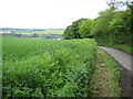
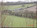
Photos of HP1 2SU


Area Information
Living in HP1 2SU means being part of a tightly knit residential cluster in England, home to 1,771 people spread across a compact area. With a population density of 393 people per square kilometre, this postcode reflects a balanced mix of private homes and community spaces. The area is defined by its proximity to local schools, including Boxmoor House School and Roman Fields Academy, which cater to a range of educational needs. Daily life here is shaped by its small-scale character, with residents benefiting from nearby retail options like Co-op Long and Tesco Bovingdon, as well as easy access to rail networks. The demographic profile suggests a mature community, with a median age of 47 and a strong presence of households in the 30–64 age bracket. This makes HP1 2SU a stable, family-oriented area where home ownership is high, and the local infrastructure supports both practical needs and a sense of continuity.
- Area Type
- Postcode
- Area Size
- Not available
- Population
- 1771
- Population Density
- 393 people/km²
The property market in HP1 2SU is characterised by high home ownership, with 93% of residents living in their own homes. This suggests a mature, settled community rather than a transient rental market. The accommodation type is predominantly houses, which are likely to be larger properties suited to families or individuals seeking space. Given the small size of the postcode area, the housing stock is limited, making it a niche market for buyers seeking specific properties. The high proportion of owner-occupied homes may indicate a strong local economy and long-term residency, which could influence property values and desirability. For buyers, this means competition is likely to be focused on a limited number of available homes, with an emphasis on condition and location within the cluster.
House Prices in HP1 2SU
No properties found in this postcode.
Energy Efficiency in HP1 2SU
The lifestyle in HP1 2SU is supported by a range of nearby amenities, including retail outlets such as Co-op Long, Tesco Bovingdon, and Spar, which cater to everyday shopping needs. The area’s rail stations, including Hemel Hempstead and Berkhamsted, provide easy access to urban centres, while the Chesham Underground Station offers additional connectivity. Though the data does not specify parks or leisure facilities, the presence of multiple retail and transport options suggests a practical, convenience-driven lifestyle. Residents can expect a mix of local services and broader regional access, ensuring daily life is efficient and well-supported. The compact nature of the area means amenities are within practical reach, enhancing the overall livability for those prioritising accessibility.
Amenities
Schools
The schools near HP1 2SU include Boxmoor House School, a special school, and Roman Fields, Roman Fields Academy, and James Marks Academy, which are categorised as other types. These institutions provide a range of educational options, from specialist provision to mainstream schooling. The presence of both special and other schools suggests a diverse educational landscape, accommodating different needs within the community. Families with children may benefit from the proximity of these schools, though the absence of Ofsted ratings means performance metrics are not available. The mix of school types reflects the area’s demographic focus on adult and family-oriented living, ensuring local children have access to varied educational pathways.
| Rank | School | Type | Entry gender | Ages |
|---|
Explore more schools in this area
Go to Schools tabDemographics
HP1 2SU has a median age of 47, with the majority of residents falling within the 30–64 age range. This indicates a community skewed towards adults, likely with established careers and families. Home ownership is exceptionally high at 93%, reflecting a predominantly owner-occupied area rather than a rental market. The accommodation type is largely houses, which aligns with the demographic profile of older, settled households. The predominant ethnic group is White, which shapes the cultural and social dynamics of the area. With no data on deprivation levels, it is reasonable to infer that the area’s stability and high home ownership contribute to a relatively consistent quality of life. The absence of significant diversity metrics suggests a homogenous community, which may influence local social interactions and amenities.
Household Size
Accommodation Type
Tenure
Ethnic Group
Religion
Household Composition
Age
Household Deprivation
NS-SEC
Explore more demographic insights in this area
Go to Demographics tabPlanning
Planning Constraints
- Flood RiskPremium
- Ramsar Wetland SitesPremium
- Area of Outstanding Natural BeautyPremium
- Protected Nature ReservePremium
- Protected WoodlandPremium