Area Overview for HP1 1LT
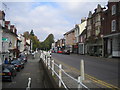
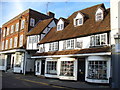
Photos of HP1 1LT


Area Information
HP1 1LT is a small residential postcode area in England, characterised by its compact cluster of homes and a population of 1670 people. With a population density of 1440 people per square kilometre, this area is densely populated yet retains a distinct residential identity. Daily life here is shaped by proximity to essential services and transport links, making it practical for commuters and families alike. The area is not defined by sprawling developments but by tightly grouped housing, which contributes to a sense of community. Residents benefit from nearby amenities such as retail outlets and railway stations, ensuring convenience without the need for long commutes. While the area lacks large-scale natural features, its strategic location offers access to regional hubs. For those seeking a balance between urban convenience and residential tranquillity, HP1 1LT provides a focused environment where living is functional and accessible.
- Area Type
- Postcode
- Area Size
- Not available
- Population
- 1670
- Population Density
- 1440 people/km²
The property market in HP1 1LT is largely owner-occupied, with 54% of homes owned by residents rather than rented. This indicates a stable market where long-term investment is common. The predominant accommodation type is houses, which suggests a preference for detached or semi-detached properties over flats or apartments. Given the small size of the area, the housing stock is likely limited, making it a niche market for buyers seeking specific properties. The focus on owner-occupation implies that rental availability may be constrained, which could influence competition for available homes. For buyers, this means a need to act decisively, as the limited supply may lead to rapid price fluctuations. The character of the area—centred on houses—also suggests a quieter, more traditional residential feel compared to high-density developments.
House Prices in HP1 1LT
No properties found in this postcode.
Energy Efficiency in HP1 1LT
Residents of HP1 1LT have access to a range of nearby amenities, including retail outlets such as Asda Hemel, Iceland Hemel, and Tesco Hemel. These stores provide convenience for grocery shopping and daily essentials. The area’s proximity to railway stations—Hemel Hempstead, Apsley, and Kings Langley—enhances connectivity to broader regional networks, supporting commuting and leisure travel. While the data does not mention parks or leisure facilities, the presence of retail and transport options suggests a practical lifestyle focused on accessibility. The compact nature of the area means that amenities are within walking or short driving distance, fostering a sense of convenience. However, the absence of detailed information on recreational spaces means that outdoor activities may require travel beyond the immediate vicinity.
Amenities
Schools
The nearest school to HP1 1LT is George Street Primary School, which serves the local community with primary education. It holds an Ofsted rating of ‘good’, reflecting satisfactory standards in teaching and student outcomes. While no secondary schools are listed in the data, the presence of a primary school suggests that families with young children may find the area suitable for their needs. The absence of additional schools, however, means that residents may need to travel further for secondary education or specialist provisions. This mix of school types—primarily primary—indicates that the area is well-served for early years education but may require planning for older children’s schooling.
| Rank | School | Type | Entry gender | Ages |
|---|
Explore more schools in this area
Go to Schools tabDemographics
The community in HP1 1LT is predominantly composed of adults aged 30–64, with a median age of 47. This suggests a mature population, likely with established careers and families. Home ownership is prevalent, with 54% of residents owning their homes, indicating a stable housing market. The accommodation type is primarily houses, reflecting a preference for detached or semi-detached properties. The predominant ethnic group is White, which aligns with broader demographic trends in the region. While the data does not specify deprivation levels, the high home ownership rate and age profile suggest a population with relatively stable economic conditions. This demographic structure supports a community focused on long-term residency rather than transient living, contributing to a cohesive local environment.
Household Size
Accommodation Type
Tenure
Ethnic Group
Religion
Household Composition
Age
Household Deprivation
NS-SEC
Explore more demographic insights in this area
Go to Demographics tabPlanning
Planning Constraints
- Flood RiskPremium
- Ramsar Wetland SitesPremium
- Area of Outstanding Natural BeautyPremium
- Protected Nature ReservePremium
- Protected WoodlandPremium