Area Overview for Halvergate
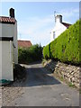
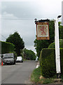
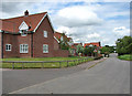
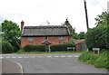
Photos of Halvergate

Area Information
Living in Halvergate offers a compact, well-defined community within a built-up area spanning 32.7 hectares. The area’s character is shaped by its modest size and the presence of nearby transport links, including five railway stations such as Acle and Berney Arms, which provide regular connections to surrounding regions. With a median age of 70, the population reflects a mature demographic, suggesting a community that values stability and established living. Homeownership is high, at 82%, indicating a strong preference for long-term residency. Daily life in Halvergate is punctuated by accessible amenities, from retail outlets like M&S Acle BP to the Reedham Ferry North, which offers practical water transport options. While the area’s size limits sprawling development, it fosters a sense of closeness, with residents likely to know their neighbours and rely on local services. For those seeking a quieter, settled environment with essential infrastructure nearby, Halvergate provides a straightforward, no-frills lifestyle.
- Area Type
- Built Up Area 250
- Area Size
- 32.7 hectares
- Population
- Not available
- Population Density
- Not available
Residents of Halvergate have access to a range of local amenities within practical reach. Five railway stations, including Acle and Berney Arms, provide frequent connections to nearby areas, while retail options such as M&S Acle BP and the East of England Co-operative Co cater to daily shopping needs. The Reedham Ferry North adds a unique touch, offering water transport that may be particularly useful for local travel or leisure. Though the area’s size limits the presence of large supermarkets or entertainment venues, the proximity of these amenities ensures convenience for basic needs. The mix of retail, transport, and ferry access contributes to a functional lifestyle, where residents can manage errands, commute, and even explore nearby water routes without needing to travel far.
Amenities
Schools
| Rank | School | Type | Entry gender | Ages |
|---|
Explore more schools in this area
Go to Schools tabDemographics
Halvergate’s population is predominantly older, with a median age of 70, reflecting a community where retirees and long-term residents form the majority. Homeownership rates are notably high at 82%, suggesting that most residents are owner-occupiers rather than renters. The data does not specify household composition or ethnic diversity, but the ‘total’ category for both indicates a broad mix of family structures and backgrounds. The area’s age profile implies a population that may prioritise low-maintenance living and proximity to essential services. While no specific figures on deprivation or income levels are provided, the high home ownership and mature demographic suggest a relatively stable economic environment. However, without further data, it is difficult to assess the full spectrum of social or economic challenges that may exist.