Area Overview for Grundisburgh
Photos of Grundisburgh

Area Information
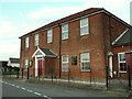
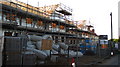
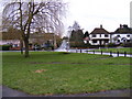
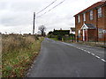
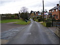
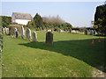
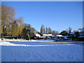
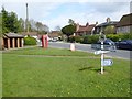
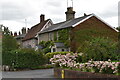
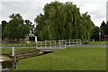
Grundisburgh is a rural parish located in the East Suffolk district of Suffolk, England. It lies approximately six miles north-east of Ipswich and four miles north-west of Woodbridge on the B1079 road. The area encompasses 78.5 hectares and holds a population of 1,584 residents. This built-up area retains the character of a traditional village with a parish setting, local amenities, and surrounding countryside. The settlement dates back to the Middle Saxon era, with historical records found in the Domesday Book of 1086. The name derives from Old English, referring to a fortified place linked to an Iron Age fort. The location features the rivers Lark and Gull flowing through it, offering a quiet, community-focused atmosphere. Residents enjoy a distinct blend of history and modern living, situated near listed landmarks including St Mary's Church and the Grade II* Basts. The village also hosts the Grundisburgh Baptist Chapel built in 1798 and the site of the 1807 Post Mill. With over 27 listed buildings, Grundisburgh offers a strong connection to the past while serving contemporary families and commuters. The area supports a volunteer-published local news service, reinforcing its tight-knit community identity.
- Area Type
- Built Up Area 250
- Area Size
- 78.5 hectares
- Population
- Not available
- Population Density
- Not available
Daily life in Grundisburgh revolves around a small selection of local amenities and historic landmarks. You will find five retail outlets nearby, including a Waitrose Little and branches of the East of England Co-operative Co, providing access to supermarkets and daily necessities. Public transport includes rail access to Woodbridge and Melton, though bus and train schedules require individual checking. For leisure, two pubs and a leisure centre often feature within the immediate area, and The Dog is a specific pub listed as a local fixture. The village also boasts seven parks and several churches, including the Grade I listed St Mary's Church with its 15th-century hammerbeam roof. Walkers can explore along the rivers Lark and Gull or visit Post Mill Gardens. The local community maintains the Grundisburgh and District News, published every three months by volunteers. This indicates a strong commitment to local information sharing. Dining and shopping options are concentrated but sufficient for weekly needs. The presence of historical sites and a single main estate ensures a peaceful environment without urban clutter.
Amenities
Schools
Families in Grundisburgh benefit from direct access to local education infrastructure, specifically Grundisburgh Primary School. This state-funded school serves the local catchment and holds a Good Ofsted rating, which grants parents confidence in the quality of education provided. The presence of a-rated primary school in the immediate village area means you do not need to commute for early years education. Oldell Primary School and other institutions beyond this immediate list may serve older children if available in neighbouring parishes, though only Grundisburgh Primary is recorded as the nearest option. The single primary school situation suggests a focused, community-run educational environment rather than a competitive school chain.Residents of Grundisburgh will find that school travel times are short, particularly for younger children attending the local primary facility. The Good rating from Ofsted provides a baseline assurance of standards within the schoolhouse. For children progressing to secondary age, options will likely lie within the wider East Suffolk district, requiring further research on catchment boundaries outside this specific data set.
| Rank | School | Type | Entry gender | Ages |
|---|
Explore more schools in this area
Go to Schools tabDemographics
The community of Grundisburgh is defined by an older population. The median age stands at 70 years, making this the most common age range among residents. This demographic profile indicates a settlement where retirees and long-term locals form the majority. Home ownership is extremely prevalent, with 80% of households owning their properties. Consequently, the rental sector remains a minor component of the local housing market. You will find a population deeply invested in the area rather than transient commuters passing through. The specific household composition and predominant ethnic group data are not detailed in current records, but the high ownership rate suggests stability. This level of tenure typically correlates with a slower pace of life and established neighbourhood ties. The absence of a young family demographic alongside the high age median shapes local services and social activities. Residents here likely prioritise low-maintenance living and community connection over rapid property turnover. The demographic structure reflects a classic rural parish where generations have lived through the same local changes. Understanding this profile is essential for anyone considering a move, as the social environment caters primarily to an older, settled population.
Household Size
Accommodation Type
Tenure
Ethnic Group
Religion
Household Composition
Age
Household Deprivation
NS-SEC
Explore more demographic insights in this area
Go to Demographics tabPlanning
Planning Constraints
- Crime RiskPremium