Area Overview for Great Staughton
Photos of Great Staughton


Area Information
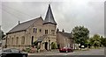
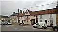
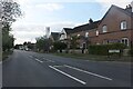
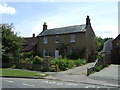
Great Staughton is a distinct built-up area in Cambridgeshire with a strong rural identity despite post-war growth. This small settlement covers an area of 28.6 hectares and sits approximately eight miles south-west of Huntingdon. The landscape features three defined sections, including the historic Town and the Highway along the B645 road. You will find yourself surrounded by significant history, from Neolithic settlement traces to a Roman villa dating between 130 and 370 AD. Scheduled monuments include the site of a Roman small town south of the village and Cretingsbury, the earthworks of a former motte and bailey castle. The parish retains a quiet character defined by a 13th-century Church of St. Andrew and the White Hart, a historic 17th-century coaching inn. Living in Great Staughton means enjoying a blend of modern residential development and ancient heritage without the density of a larger town. Your daily life is shaped by proximity to these local landmarks while remaining connected to the wider Huntingdonshire district. The area offers a grounded experience far removed from the starkness of urban environments, providing residents with a sense of place rooted in deep history and natural surroundings.
- Area Type
- Built Up Area 250
- Area Size
- 28.6 hectares
- Population
- Not available
- Population Density
- Not available
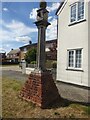
Your daily lifestyle in Great Staughton centres around five specific retail outlets within easy reach. The local high street offers a practical selection including Budgens Kimbolton, a Co-op in Little, and another Co-op in Eaton. These stores provide for everyday shopping needs for residents living in Great Staughton. Beyond retail, rail access connects the area to St Neots Railway Station, which sits just one stop or short drive away from the village. This transport link facilitates travel to Huntingdon and London King's Cross efficiently. The village itself is defined by historic charm, featuring the 1637 sundial by Edmund Ibbutt on the Highway. You can also explore the White Hart, a historic coaching inn from the 17th century, which adds character to any leisure outing. Parks and open spaces define the landscape, offering quiet routes for walking away from the main thoroughfares. The architecture includes Place House, built in 1539, providing a glimpse into the Tudor past. Amenities are practical and locally focused, ensuring you do not need to travel far for standard goods or services. Living in Great Staughton offers a blend of rural solitude and accessible convenience.
Amenities
Schools
Families living in Great Staughton rely on two specific primary education providers located near the village. Great Staughton Primary School serves the immediate area alongside Great Staughton Primary Academy, which holds primary status. Both institutions fall under the primary education sector, catering to children up to the age of eleven. These schools represent the main educational hubs for residents within the parish boundaries. There are no secondary schools listed in the immediate vicinity for the data provided, meaning older children typically travel to larger towns for further education. The presence of these two primary options ensures that young children can begin their learning journey locally without long commutes. Parents will need to consider transport to secondary colleges once compulsory education moves beyond primary age. The concentration of primary facilities reflects the village's focus on settling young families early before they disperse for high school. Both schools are fixed points on the local map for parents looking at schools near Great Staughton. The mix indicates a dedicated local infrastructure for early childhood and primary education needs.
| Rank | School | Type | Entry gender | Ages |
|---|
Explore more schools in this area
Go to Schools tabDemographics
The community within Great Staughton is heavily weighted towards older residents. Demographic data confirms a median age of 70, indicating that most inhabitants are seniors seeking a settled lifestyle. Every element of the local social fabric reflects this shift in population age. You move through neighbourhoods populated by those with vast personal histories rather than young families or commuters. This demographic profile suggests a community where neighbours are likely familiar with one another across generations. The population structure points to a retirement-focused village where daily interactions centre around shared experiences of later life. With a median age this high, you should expect the local amenities and pace to cater to an older demographic. The lack of younger age brackets means the village does not feel transient. This social composition creates a predictable environment where long-term residency norms apply. Your experience of living in Great Staughton will be defined by this steady, mature population profile. The area has evolved into a destination for those seeking stability and a quiet retreat from younger, faster-paced boroughs.
Household Size
Accommodation Type
Tenure
Ethnic Group
Religion
Household Composition
Age
Household Deprivation
NS-SEC
Explore more demographic insights in this area
Go to Demographics tabPlanning
Planning Constraints
- Crime RiskPremium